MyTopo
Culbertson Montana US Topo Map
Couldn't load pickup availability
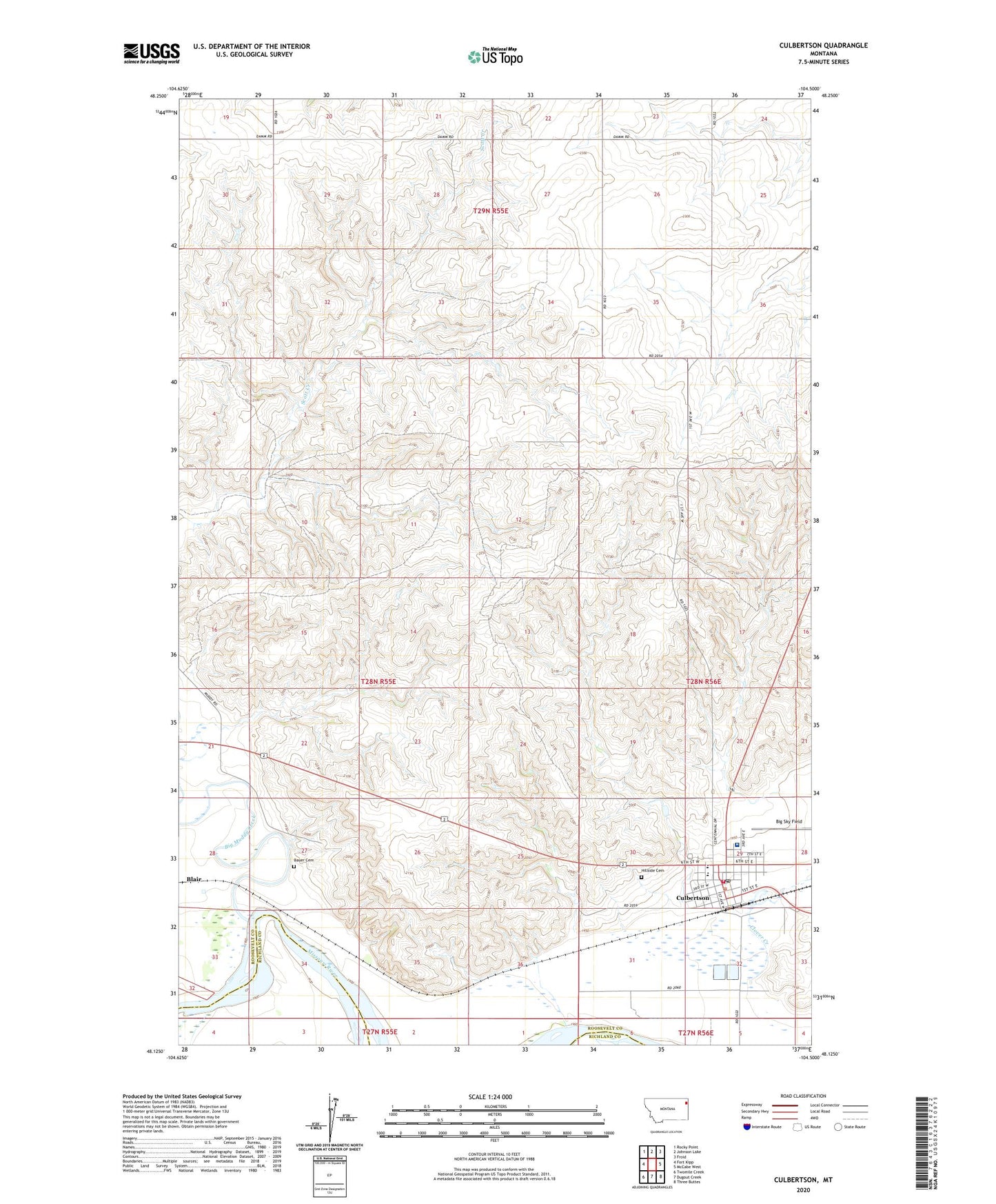
2024 topographic map quadrangle Culbertson in the state of Montana. Scale: 1:24000. Based on the newly updated USGS 7.5' US Topo map series, this map is in the following counties: Roosevelt, Richland. The map contains contour data, water features, and other items you are used to seeing on USGS maps, but also has updated roads and other features. This is the next generation of topographic maps. Printed on high-quality waterproof paper with UV fade-resistant inks.
Quads adjacent to this one:
West: Fort Kipp
Northwest: Rocky Point
North: Johnson Lake
Northeast: Froid
East: McCabe West
Southeast: Three Buttes
South: Dugout Creek
Southwest: Twomile Creek
This map covers the same area as the classic USGS quad with code o48104b5.
Contains the following named places: 28N55E01CB__01 Well, 28N55E22BB__01 Well, 28N55E23ABDB01 Well, 28N55E23AD__01 Well, 28N55E24BA__01 Well, 28N55E24DD__01 Well, 28N55E27AC__01 Well, 28N55E27BA__01 Well, 28N55E28CD__01 Well, 28N55E33DA__01 Well, 28N55E34AA__01 Well, 28N55E34AA__02 Well, 28N55E35AD__01 Well, 28N55E36AA__01 Well, 28N55E36AA__02 Well, 28N55E36AA__03 Well, 28N55E36BD__01 Well, 28N55E36CD__01 Well, 28N56E06AD__01 Well, 28N56E07AA__01 Well, 28N56E07ADCA01 Well, 28N56E20CA__01 Well, 28N56E20CB__01 Well, 28N56E29AC__01 Well, 28N56E29BC__01 Well, 28N56E29BC__02 Well, 28N56E29BC__03 Well, 28N56E29CB__01 Well, 28N56E29CD__01 Well, 28N56E29DB__01 Well, 28N56E29DC__01 Well, 28N56E29DD__01 Well, 28N56E30CC__01 Well, 28N56E30DD__01 Well, 28N56E32AA__01 Well, 28N56E32DB__01 Well, 28N56E32DD__02 Well, Bauer Cemetery, Bethel Free Lutheran Church, Big Muddy Creek, Big Sky Field, Bruegger Centennial Park, C C Recreation Complex, Clover Creek, Culbertson, Culbertson Police Department, Culbertson Post Office, Culbertson Public Library, Culbertson School, Culbertson Sewage Disposal Ponds Dam, Culbertson Volunteer Fire Department, Damm School Number Two, Everson-Clayton Mortuary Chapel, Farmers Elevator Company Elevator, Finnicum Mobile Home Park, First Baptist Church, Fish Camp, Helton Nursing Home, Hillside Cemetery, LeClair School, Liberty School, Mrs Spiegelbergs Hospital, Newtons Maternity Hospital, Pleasant View School, Presbyterian Church, Reorganized Church of Jesus Christ of Latter Day Saints, Roosevelt County Sheriff's Office Substation, Roosevelt Medical Center, Roosevelt Memorial Clinic, Roosevelt Memorial Nursing Home, Saint Anthonys Catholic Church, Saint Pauls Lutheran Church, Saxton Independent Elevator, Swimming Pool Park, Town of Culbertson, Trinity Lutheran Church, United Methodist Church, Walker Mobile Home Park