MyTopo
Cut Bank Montana US Topo Map
Couldn't load pickup availability
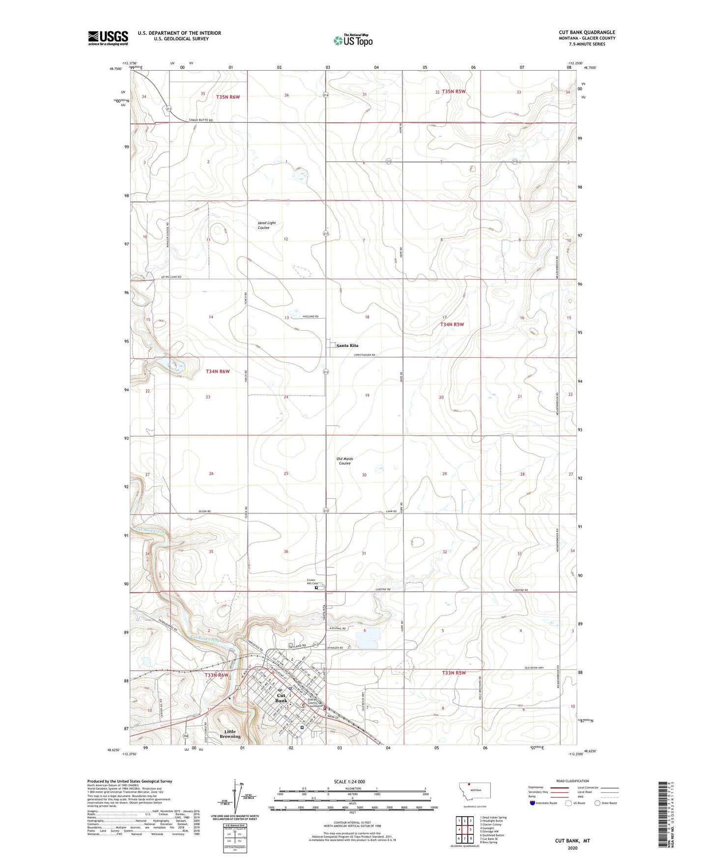
2024 topographic map quadrangle Cut Bank in the state of Montana. Scale: 1:24000. Based on the newly updated USGS 7.5' US Topo map series, this map is in the following counties: Glacier. The map contains contour data, water features, and other items you are used to seeing on USGS maps, but also has updated roads and other features. This is the next generation of topographic maps. Printed on high-quality waterproof paper with UV fade-resistant inks.
Quads adjacent to this one:
West: Gunsight
Northwest: Dead Indian Spring
North: Headlight Butte
Northeast: Glacier Colony
East: Ethridge NW
Southeast: Boru Spring
South: Cut Bank SE
Southwest: Duckhead Buttes
This map covers the same area as the classic USGS quad with code o48112f3.
Contains the following named places: 33N05W05BA__01 Well, 33N05W06BB__01 Well, 33N05W06BC__01 Well, 33N05W06CB__01 Well, 33N05W07DB__01 Well, 33N05W08CC__01 Well, 33N05W08CD__01 Well, 33N06W11BD__01 Well, 33N06W12AA__01 Well, 33N06W12AAA_02 Well, 33N06W12AAA_03 Well, 34N05W03BB__01 Well, 34N05W03CC__01 Well, 34N05W05BC__01 Well, 34N05W09AA__01 Well, 34N05W09BD__01 Well, 34N05W18CC__01 Well, 34N05W20BB__01 Well, 34N05W20DD__01 Well, 34N05W29DA__01 Well, 34N05W29DA__02 Well, 34N05W30BB__01 Well, 34N05W31BC__01 Well, 34N05W31CD__01 Well, 34N05W32CC__01 Well, 34N05W34BB__01 Well, 34N06W02CB__01 Well, 34N06W11BA__01 Well, 34N06W11CC__01 Well, 34N06W12CC__01 Well, 34N06W13AC__01 Well, 34N06W13BC__01 Well, 34N06W14BA__01 Well, 34N06W14BC__01 Well, 34N06W14DD__01 Well, 34N06W14DD__02 Well, 34N06W24DA__01 Well, 34N06W36AD__01 Well, 35N06W34AD__01 Well, 35N06W34DD__01 Well, 35N06W35CCBD01 Well, Anna Jeffries Elementary School, City of Cut Bank, Crown Hill Cemetery, Cut Bank, Cut Bank Ambulance Services, Cut Bank Assembly of God Church, Cut Bank Church of Christ, Cut Bank Community Bible Church, Cut Bank High School, Cut Bank Middle School, Cut Bank Police Department, Cut Bank Post Office, Cut Bank Sewage Disposal Pond Dam, Cut Bank Sewage Lagoon Dam, Cut Bank Volunteer Fire Department, Evangelical Free Church, First Presbyterian Church, Gary Smith Memorial, General Mills Incorporated Elevator, Glacier County Courthouse, Glacier County Emergency Medical Services Headquarters, Glacier County Emergency Medical Services Station 1, Glacier County Historical Society Museum, Glacier County Library, Glacier County Medical Center Nursing Home, Glacier County Medical Clinic, Glacier County Rural Fire Department, Glacier County Sheriff's Office, H C Davis Elementary, Hagerty Dam, Harvest States Cooperatives Elevator, Jehovah's Witnesses, Little Browning Census Designated Place, Meadowbrook School, Montana Wheat Growers Incorporated Elevator, Northern Rockies Medical Center - Hospital, Northern Village Shopping Center, Old Maids Coulee, Physical Therapy Clinic, Riverview Campground, Saint Margarets Catholic Church, Saint Paul Lutheran Church, Santa Rita, Santa Rita Census Designated Place, Santa Rita Post Office, Skyland Trailer Park, The Church of Jesus Christ of Latter Day Saints, Tri-County Chiropractic Clinic, Winkler School, Yunck Dam