MyTopo
Hays Montana US Topo Map
Couldn't load pickup availability
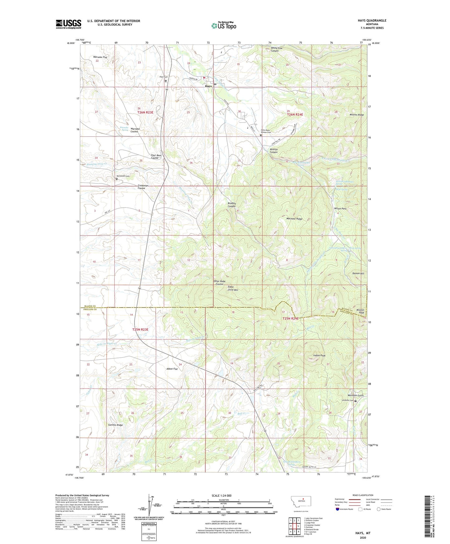
2024 topographic map quadrangle Hays in the state of Montana. Scale: 1:24000. Based on the newly updated USGS 7.5' US Topo map series, this map is in the following counties: Blaine, Phillips. The map contains contour data, water features, and other items you are used to seeing on USGS maps, but also has updated roads and other features. This is the next generation of topographic maps. Printed on high-quality waterproof paper with UV fade-resistant inks.
Quads adjacent to this one:
West: Crazyman Coulee
Northwest: Lake Seventeen East
North: Stiffarm Coulee
Northeast: Lodge Pole
East: Zortman
Southeast: Hays SE
South: D Y Junction
Southwest: Shetland Divide
This map covers the same area as the classic USGS quad with code o47108h6.
Contains the following named places: 25N23E10CDDB01 Well, 25N24E04CDDD01 Well, 25N24E04CDDD02 Well, 25N24E09ADBC01 Spring, 25N24E32DABC01 Spring, 26N23E23AAD_01 Well, 26N23E23AAD_02 Well, 26N23E23ACAB01 Well, 26N23E23ACAD01 Well, 26N23E23ACAD02 Well, 26N23E23DCAD01 Well, 26N23E23DCAD02 Well, 26N23E23DCBA01 Well, 26N23E23DCBA02 Well, 26N23E24ACC_01 Well, 26N23E24BBC_01 Well, 26N23E24BBDD01 Well, 26N23E24BDB_01 Well, 26N23E24BDBB01 Well, 26N23E24BDC_01 Well, 26N23E24CADD01 Well, 26N23E24DAB_01 Well, 26N23E24DBA_01 Well, 26N23E24DBBC01 Well, 26N23E24DBD_01 Well, 26N23E24DBD_02 Well, 26N23E24DDA_01 Well, 26N23E24DDB_01 Well, 26N23E24DDDB01 Well, 26N23E24DDDB02 Well, 26N23E25AAA_01 Well, 26N23E25AAA_02 Well, 26N23E25AADA01 Well, 26N23E26ACDC01 Well, 26N23E34DABD01 Well, 26N23E35CBDA01 Well, 26N24E04BAAA01 Spring, 26N24E19AACA01 Well, 26N24E19AACA02 Well, 26N24E19BDCC01 Well, 26N24E19CCB_01 Well, 26N24E19CCB_02 Well, 26N24E19CCB_03 Well, 26N24E19CCD_01 Well, 26N24E19CDC_01 Well, 26N24E19CDC_02 Well, 26N24E19CDC_03 Well, 26N24E19CDC_04 Well, 26N24E20BBBC01 Well, 26N24E30ACB_01 Well, 26N24E30ADC_01 Well, 26N24E30BAC_01 Well, 26N24E30BADB01 Well, 26N24E30BBD_01 Well, 26N24E30BCD_01 Well, 26N24E30BDAC01 Well, 26N24E30BDAC02 Well, 26N24E30BDB_01 Well, 26N24E30BDB_02 Well, 26N24E30BDBA01 Well, 26N24E30BDCB01 Well, 26N24E30CBAA01 Well, 26N24E30CBAA02 Well, 26N24E30CBAC01 Well, 26N24E30CBAD01 Well, 26N24E30CBC_01 Well, 26N24E30CDA_01 Well, 26N24E30DAB_01 Well, 26N24E30DADC01 Well, 26N24E30DADC02 Well, 26N24E30DBB_01 Well, 26N24E30DBC_01 Well, 26N24E30DBD_02 Well, 26N24E30DDAB01 Well, 26N24E31AAAA01 Well, 26N24E31AAD_01 Well, 26N24E31AAD_02 Well, 26N24E31BADC01 Well, 26N24E31BDDC01 Well, 26N24E32BCBA01 Well, 26N24E32DACB01 Spring, Abbot Flat, Alliance Bible Church, Bone Spring, Bradley Canyon, Eagle Child Mountain, Fort Belknap Volunteer Fire Department Hays, Fort Belknap Youth Camp, Gannon Ridge, Hays, Hays Cemetery, Hays Post Office, Hays-Lodge Pole School, Indian Peak, King Creek, King Spring, Landusky Cemetery, Macmeal Ridge, McConnell Cemetery, Mission Canyon, Mission Ridge, Montana Gulch, Montana Gulch Campground, North Fork Little Peoples Creek, Pine Grove, Saint Pauls Mission, Saint Pauls Mission Cemetery, Saint Pauls Post Office, South Big Horn Creek, South Fork Little Peoples Creek, Warneke Spring, White Cow Canyon, Wilson Park