MyTopo
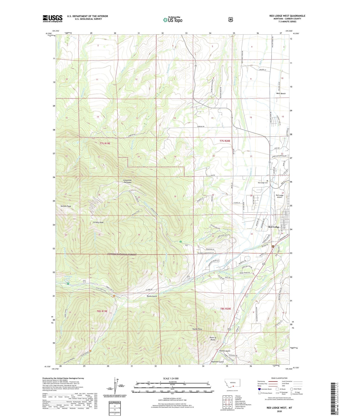
Red Lodge West Montana US Topo Map
Couldn't load pickup availability
Also explore the Red Lodge West Forest Service Topo of this same quad for updated USFS data
2024 topographic map quadrangle Red Lodge West in the state of Montana. Scale: 1:24000. Based on the newly updated USGS 7.5' US Topo map series, this map is in the following counties: Carbon. The map contains contour data, water features, and other items you are used to seeing on USGS maps, but also has updated roads and other features. This is the next generation of topographic maps. Printed on high-quality waterproof paper with UV fade-resistant inks.
Quads adjacent to this one:
West: Bare Mountain
Northwest: Roscoe
North: Castagne
Northeast: Roberts
East: Red Lodge East
Southeast: Tolman Flat
South: Mount Maurice
Southwest: Black Pyramid Mountain
This map covers the same area as the classic USGS quad with code o45109b3.
Contains the following named places: Auto Bahn Ski Trail, Barriers Ski Trail, Basin Creek, Bear Paw Ski Trail, Beartooth Elks Golf and Country Club, Beartooth Hospital and Health Center, Berrys Ski Trail, Big Bear Gulch Ski Trail, Big Silver Ski Trail, Bigfoot Ski Trail, Black Powder Ski Trail, Bobcat Ski Trail, Boomerang Ski Trail, Buckin Chute Ski Trail, Camp Rotary, Carbon County Memorial Nursing Home, Carbon County Museum, Cariboo Ski Trail, Chicken Ski Trail, Church of Christ, City of Red Lodge, Coal Chute Ski Trail, Columbine Ski Trail, Drainage Ski Trail, Draper School, Drifter Ski Trail, Dutch Creek, East Parks Ski Trail, East Side Mine Ski Trail, Easy Street Ski Trail, Face of M Ski Trail, First Street Ski Trail, Flintlock Ski Trail, Grizzly Peak, Haara Ditch, Hancock Ski Trail, Haywood Gulch, Headwaters Ski Trail, Hellroaring Ski Trail, Howell Gulch, Ingles Creek, Intimidation Ski Trail, Jones Park Ski Trail, KAFM-FM (Red Lodge), KRBN-AM (Red Lodge), Latigo Ski Trail, Lazy M Ski Trail, Limestone Palisades, Little Forest Ski Trail, Little Silver Ski Trail, Little Tree Ski Trail, Lobo Ski Trail, Lodge Pole Ski Trail, Lodge Ski Trail, Lower Barriers Ski Trail, Lower Continental Ski Trail, Lower Limited Ski Trail, Lower Miami Beach Ski Trail, Lower Royals Ski Trail, Lynns Run Ski Trail, McDonald Ditch, Meeteetse Ski Trail, Messiah Lutheran Church, Miami Beach Ski Trail, Midway Express Access Ski Trail, Mountain View Medical Center, Nichols Creek, Nichols Peak, North Forty Ski Trail, Palisades Campground, Paradise Ski Trail, Penwells Ski Trail, Perrys RV Park and Campground, Pine Ridge Ski Trail, Point of Rocks, Pryde Ditch, Red Lodge Airport, Red Lodge Cemetery, Red Lodge Mountain Golf Course, Red Lodge Mountain Ski Area, Red Lodge Ranger Station, Rock Creek Ranger Station, Saint Agnes School, Second Street Ski Trail, Show Off Alley Ski Trail, Sidesaddle Ski Trail, Silver Run Creek, Silver Ski Trail, Sluice Box Ski Trail, The Church of Jesus Christ of Latter Day Saints, The Kitchen Ski Trail, The Ridge Ski Trail, Third Street Ski Trail, Thompsons Ski Trail, Timbercrest, Tipi Ski Trail, Towne Gulch, Towne Point, True Grit Ski Trail, Turnpike Ski Trail, Upper Continental Ski Trail, Upper Limited Ski Trail, Washoe Creek, West Fork Rock Creek, West Parks Ski Trail, West Side Mine Ski Trail, Widow Maker Ski Trail, Wild Bill Lake, Wild Bill Lake Campground, Willow Creek Number 1 Mine, Winchester Ski Trail