MyTopo
Toston Montana US Topo Map
Couldn't load pickup availability
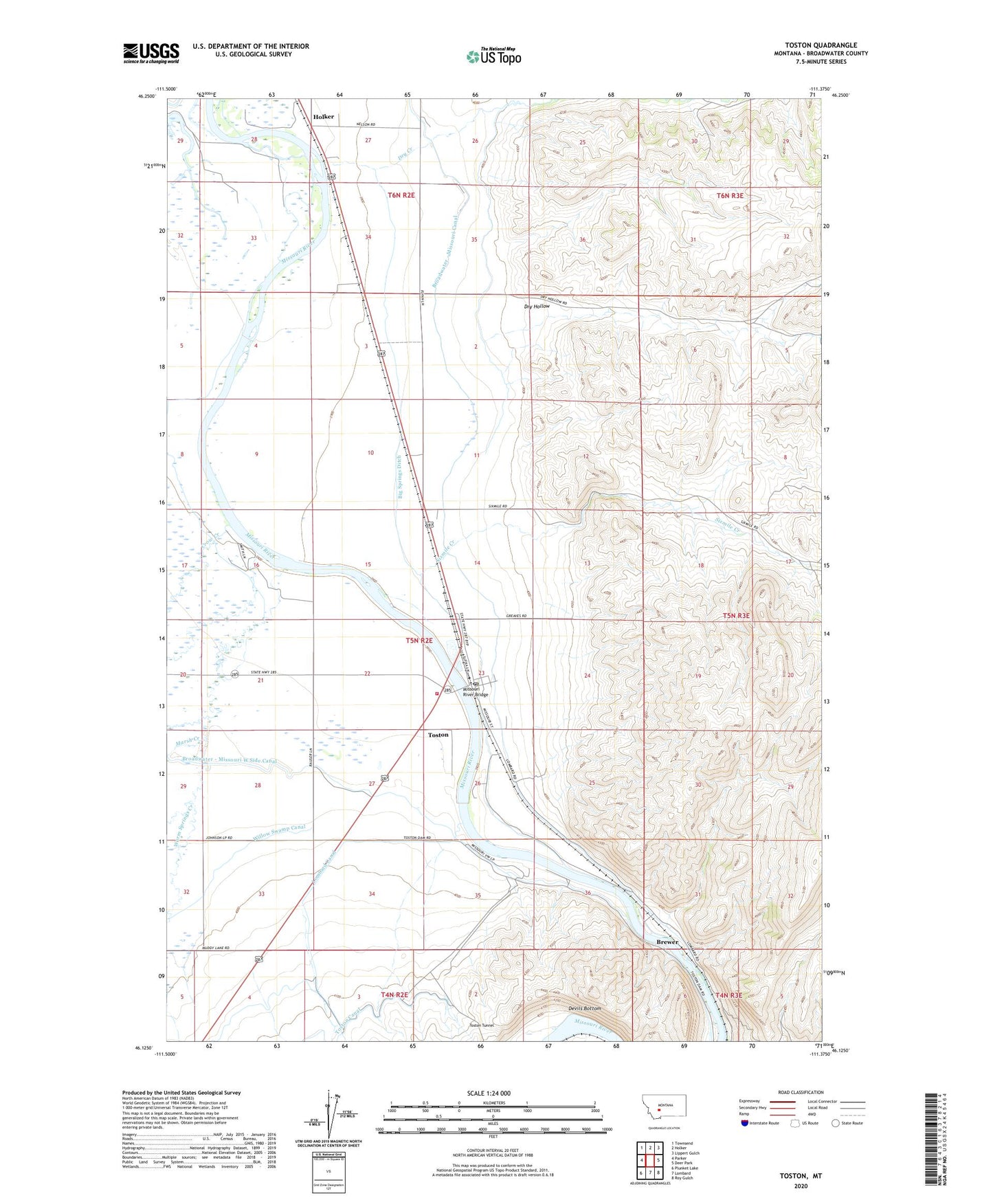
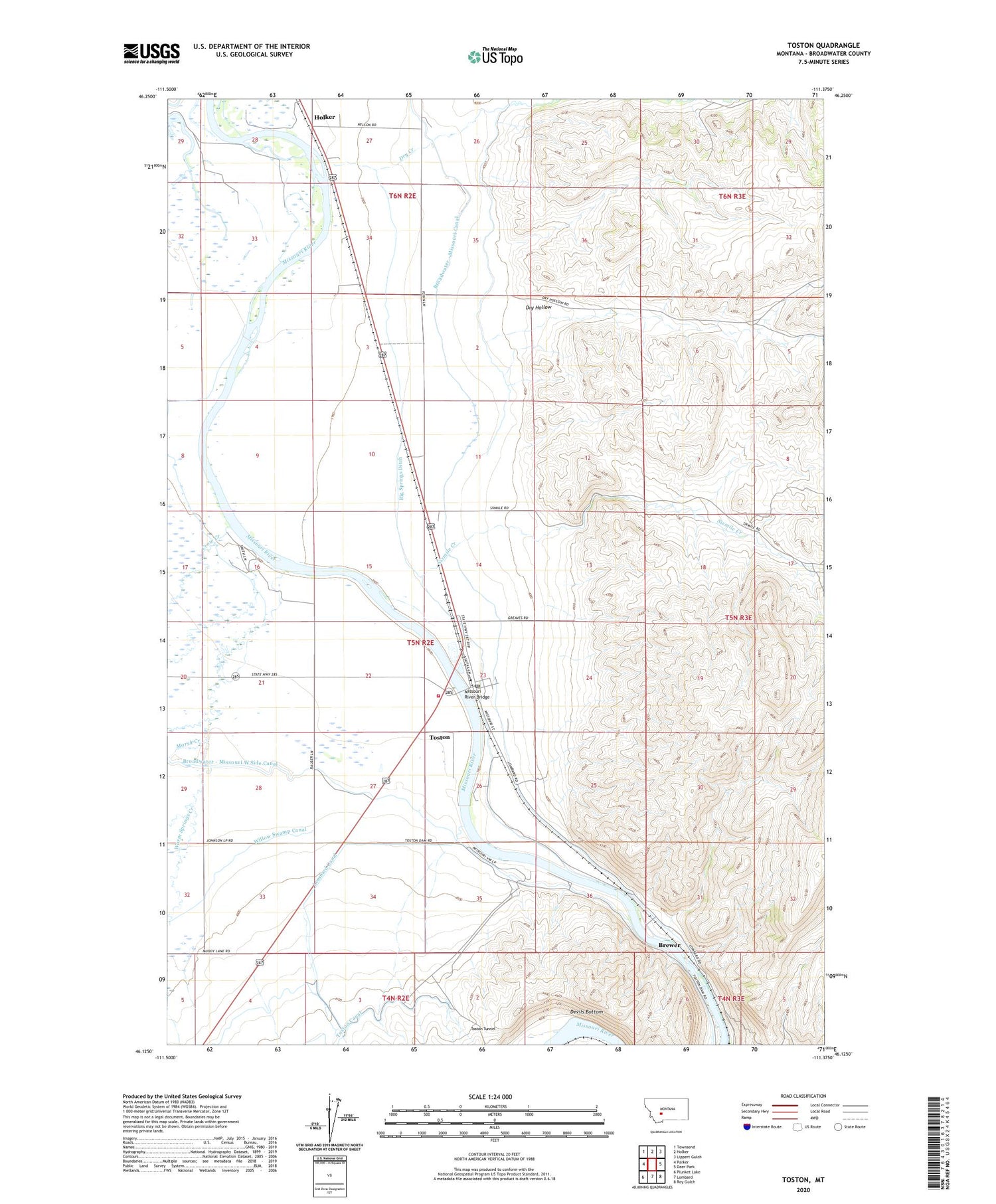
2020 topographic map quadrangle Toston in the state of Montana. Scale: 1:24000. Based on the newly updated USGS 7.5' US Topo map series, this map is in the following counties: Broadwater. The map contains contour data, water features, and other items you are used to seeing on USGS maps, but also has updated roads and other features. This is the next generation of topographic maps. Printed on high-quality waterproof paper with UV fade-resistant inks.
Quads adjacent to this one:
West: Parker
Northwest: Townsend
North: Holker
Northeast: Lippert Gulch
East: Deer Park
Southeast: Roy Gulch
South: Lombard
Southwest: Plunket Lake
Contains the following named places: 04N02E04AB__01 Well, 04N02E04BC__01 Well, 05N02E02BB__01 Well, 05N02E02CB__01 Well, 05N02E03AC__01 Well, 05N02E03ACDC01 Well, 05N02E03DA__01 Well, 05N02E03DA__02 Well, 05N02E04DB__01 Well, 05N02E04DBDA01 Well, 05N02E09CA__01 Well, 05N02E10AD__01 Well, 05N02E10ADDD01 Well, 05N02E10CBCC01 Well, 05N02E10DA__01 Well, 05N02E11BC__01 Well, 05N02E14DD__01 Well, 05N02E15AC__01 Well, 05N02E15DA__01 Well, 05N02E15DA__02 Well, 05N02E15DA__03 Well, 05N02E15DACB01 Well, 05N02E16DB__01 Well, 05N02E21AD__01 Well, 05N02E21BC__01 Well, 05N02E21BD__01 Well, 05N02E21DA__01 Well, 05N02E22AD__01 Well, 05N02E22BB__01 Well, 05N02E22BD__01 Well, 05N02E22CBBA01 Well, 05N02E22DB__01 Well, 05N02E23BBDA01 Well, 05N02E23BD__01 Well, 05N02E23CA__01 Well, 05N02E23CA__02 Well, 05N02E23CA__03 Well, 05N02E23CA__04 Well, 05N02E23CA__05 Well, 05N02E23CA__06 Well, 05N02E23CB__01 Well, 05N02E23DB__01 Well, 05N02E23DBBB01 Well, 05N02E23DBCA01 Well, 05N02E23DC__01 Well, 05N02E23DC__02 Well, 05N02E23DC__03 Well, 05N02E26AC__01 Well, 05N02E26BD__01 Well, 05N02E26CA__01 Well, 05N02E26CA__02 Well, 05N02E26CA__03 Well, 05N02E27AD__01 Well, 05N02E27ADDA01 Well, 05N02E27BB__01 Well, 05N02E27BB__02 Well, 05N02E27BB__03 Well, 05N02E27BB__04 Well, 05N02E27BC__01 Well, 05N02E27CC__01 Well, 05N02E27DD__01 Well, 05N02E28ACDA01 Well, 05N02E28AD__01 Well, 05N02E28BBCC01 Well, 05N02E28CD__01 Well, 05N02E28CDDD01 Well, 05N02E29DD__01 Well, 05N02E32AA__01 Well, 05N02E32DAAD01 Well, 05N02E32DD__01 Well, 05N02E32DD__02 Well, 05N02E33AA__01 Well, 05N02E33AB__01 Well, 05N02E33AC__01 Well, 05N02E33BB__01 Well, 05N02E33BB__02 Well, 05N02E33CB__01 Well, 05N02E33DACA01 Well, 05N02E34AADD01 Well, 05N02E34BA__01 Well, 05N02E35BA__01 Well, 05N02E35DAB_01 Well, 05N03E06AA__01 Well, 06N02E26CB__01 Well, 06N02E26CBBB01 Well, 06N02E27BDCB01 Well, 06N02E27CC__01 Well, 06N02E34AD__01 Well, 06N02E34AD__02 Well, 06N02E34BDBB01 Well, 06N02E34CA__01 Well, 06N02E34CA__02 Well, 06N02E34CD__01 Well, 06N02E34DC__01 Well, 06N02E34DD__01 Well, Big Springs Ditch, Brewer, Broadwater - Missouri Canal, Crow Creek, Devils Bottom, Devils Bottom Mine, Dry Creek, Dry Hollow, Lombard Canal, Marsh Creek, Methodist-Episcopal Church, Missouri River Bridge, Missouri River Grain Company Elevator, Sixmile Creek, The Church of Jesus Christ of Latter Day Saints, Toston, Toston Catholic Church, Toston Census Designated Place, Toston Fishing Access Site, Toston Methodist Church, Toston Mine, Toston Post Office, Toston School, Toston Tunnel, Toston Volunteer Fire Department, Warm Springs Creek