MyTopo
Elkhorn Nebraska US Topo Map
Couldn't load pickup availability
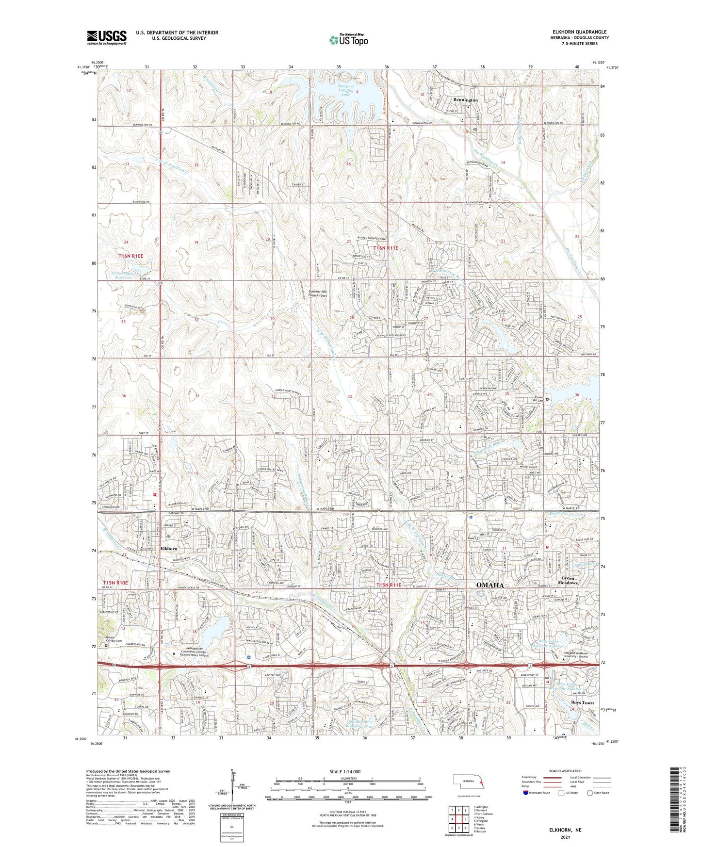
2021 topographic map quadrangle Elkhorn in the state of Nebraska. Scale: 1:24000. Based on the newly updated USGS 7.5' US Topo map series, this map is in the following counties: Douglas. The map contains contour data, water features, and other items you are used to seeing on USGS maps, but also has updated roads and other features. This is the next generation of topographic maps. Printed on high-quality waterproof paper with UV fade-resistant inks.
Quads adjacent to this one:
West: Valley
Northwest: Arlington
North: Kennard
Northeast: Fort Calhoun
East: Irvington
Southeast: Ralston
South: Gretna
Southwest: Wann
This map covers the same area as the classic USGS quad with code o41096c2.
Contains the following named places: Aldrich Elementary School, Alice Buffet Magnet Middle School, Bennington, Bennington Creek, Bennington Elementary School, Bennington Police Department, Bennington Post Office, Bennington Public Library, Bennington Volunteer Fire and Rescue, Beth El Synagogue, Bethany Lutheran Church, Boys Town, Boys Town Center Clinic, Boys Town Dam Number 1, Boys Town Dam Number 3, Boys Town Department of Fire and Rescue, Boys Town High School, Boys Town Library Services, Boys Town Post Office, Boys Town Reservoir Number 1, Boys Town Reservoir Number 3, Candlewood Community Church, Childrens Urgent Care Center, City of Bennington, Cottonwood Elementary School, Covenant Presbyterian Church, Douglas County, Douglas County Sheriff's Office, Eagle Run Golf Course, Elkhorn, Elkhorn City Police Department, Elkhorn Community Church, Elkhorn Election Precinct, Elkhorn Eye Clinic, Elkhorn Family Care Center, Elkhorn Fire Department, Elkhorn High School, Elkhorn Hills Methodist Church, Elkhorn Manor Nursing Center, Elkhorn Middle School, Elkhorn Post Office, Elkhorn Public Library, Elkhorn Ridge Golf Course, Evergreen Dental Group PC Building, Ezra Millard Elementary School, Family Medical Center, Father Flanagans Boys Home Historical Marker, Father Flanagans Boys Home Library, Fitzgerald Veterans Home, Flower Hill Cemetery, Fullerton Magnet Center, Grace Abbott Elementary School, Green Meadows, Hanover Creek, Hi Land Mobile Home Park, Hillrise Elementary School, Hillsborough Family Dentistry Center, Hillsborough Plaza, Huntington Creek, Huntington Park, Immaculate Conception Catholic Church, Indian Creek, Indian Creek Golf Course, Jefferson Election Precinct, Lifegate Christian School, Lockwood Creek, Lord of Life Lutheran Church, Marcuzzo Chiropractic Clinic, McArdle Election Precinct, Methodist Women's Hospital, Metropolitan Community College - Elkhorn Valley Campus, Millard North High School, Mount Calvary Cemetery, Newport Landing Lake, North Branch West Papillion Creek, North Standing Bear Creek, Old Lincoln Highway Creek, Omaha Fire Department Station 78, Omaha Regency, One Hundred Forty-Fourth Street Parkway Trail, Our Saviours Baptist Church, Pacific Springs Golf Course, Papillion Creek Dam D-45, Papillion Creek Reservoir D-45, Papio Dam Site Sixteen Park, Peace Presbyterian Church, Peter Kiewit Middle School, Physicians Clinic, Picotte Elementary School, Ridgewood Creek, Sachs-Palmer Dam, Sachs-Palmer Reservoir, Saint Augustines Episcopal Church, Saint Johns Lutheran Church, Saint Patricks Catholic School, Saint Patricks Church of Elkhorn, Saint Vincent Catholic Church, Saint Vincent De Paul School, School Number 67, Skyline Dental Center, Skyline Elementary School, Skyline Medical Center, South Standing Bear Creek, Standing Bear Lake Park, Standing Bear Reservoir, Summer Hill Farm Airport, Sunny Side School, The Champions Club, The Church of Jesus Christ of Latter Day Saints, Thompson Creek, Trinity Church Interdenominational, University Medical Associates Building - Eagle Run, Village of Boys Town, Wegner Middle School, West Maple Pediatric Clinic, Westridge Elementary School, Westside Baptist Church, Whispering Ridge Creek, Zion Church, ZIP Codes: 68007, 68010, 68116, 68118