MyTopo
Pinto Summit Nevada US Topo Map
Couldn't load pickup availability
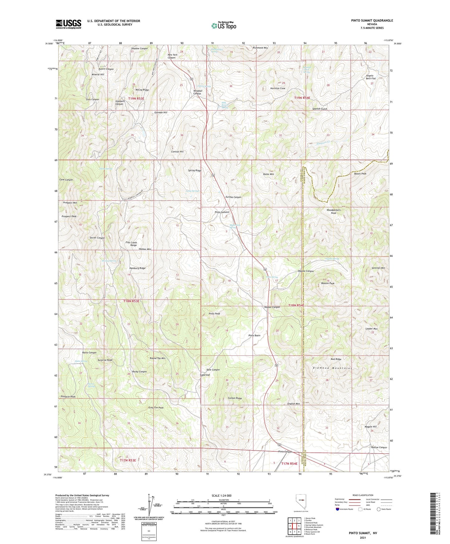
2021 topographic map quadrangle Pinto Summit in the state of Nevada. Scale: 1:24000. Based on the newly updated USGS 7.5' US Topo map series, this map is in the following counties: Eureka, White Pine. The map contains contour data, water features, and other items you are used to seeing on USGS maps, but also has updated roads and other features. This is the next generation of topographic maps. Printed on high-quality waterproof paper with UV fade-resistant inks.
Quads adjacent to this one:
West: Spring Valley Summit
Northwest: Devon Peak
North: Eureka
Northeast: Diamond Peak
East: Silverado Mountain
Southeast: Black Point
South: Pinto Summit SW
Southwest: Bellevue Peak
This map covers the same area as the classic USGS quad with code o39115d8.
Contains the following named places: American Shaft, Angelo Belli Flat, Atlas Shaft, Atlas Tunnel, Basalt Peak, Beacon Peak, Berryman Tunnel, Black Pitch Spring, Bullwhacker Spring, Burning Moscow Mine, California Tunnel, Carbon Ridge, Charter Tunnel, Cherry Spring, Chicago Tunnel, Clarks Spring, Colorado Tunnel, Conelly Mine, Conical Hill, Croesus Mine, Dale Canyon, Dead Broke Tunnel, Diamond Mine, Diamond Tunnel, Distinction Tunnel, Dome Mountain, Dominic Tunnel, Dunderberg Mine, Eldorado Mine, Eldorado Tunnel, Empire Mine, English Mountain, Eureka County Hospital, Eureka Mining District, Eureka Nevada Tunnel, Eureka Secret Canyon Mines, Eureka Tunnel, Excelsior Tunnel, Fourth of July Tunnel, Fraser Tunnel, Frenchmans Tunnel, Geddes Post Office, Geddes-Bertrand Mine, Gordon Tunnel, Gorman Hill, Grant Mine, Grey Fox Peak, Hamburg Mine, Hamburg Ridge, Hoosac Canyon, Hoosac Mine, Hoosac Mountain, Hornitos Cone, Industry Mine, Industry Tunnel, Jackson Shaft, Lawton Shaft, Leader Mountain, Lexington Mine, Long Lost Jewel Tunnels, Lord Byron Tunnel, Lucky Springs, Macintosh Tunnel, Magnet Shaft, Magpie Hill, Maryland Wells, Mayberry Tunnel, McCoy Ridge, Merritt Tunnel, Metamoras Shaft, Milk Ranch Spring, Mineral Hill, Murray Spring, New Windfall Shaft, New York Canyon, Old Jackson Shaft, Orange Mine, Oswego Mine, Otto Mine, Oxyoke Canyon, Oxyoke Spring, Page and Corwin Mine, Phoenix Shaft, Pinnacle Peak, Pinto, Pinto Basin, Pinto Canyon, Pinto Peak, Pinto Post Office, Pinto Spring, Pinto Summit, Prospect Mountain, Prospect Peak, Ratto Spring, Red Ridge, Rescue Canyon, Roberts Tunnel, Rocky Canyon, Rogers Tunnel, Round Top Mountain, Ruby Hill Mine, Schaefer Ranch, Secret Valley Mine, Sentinel Mountain, Seventysix Shaft, Shadow Canyon, Sierra Springs, South Gate, Spanish Gulch Spring, Spring Ridge, Star of the West Mine, Sterling Mine, Sterling Tunnel, Stockton Mine, Sugarloaf, Surprise Peak, Twin Hoosac Tunnel, Uncle Sam Tunnel, Vanderbilt, Wabash Tunnel, Williams Mine, Windfall Canyon, Windfall Mine, Woodpeckers Peak