MyTopo
Center Sandwich New Hampshire US Topo Map
Couldn't load pickup availability
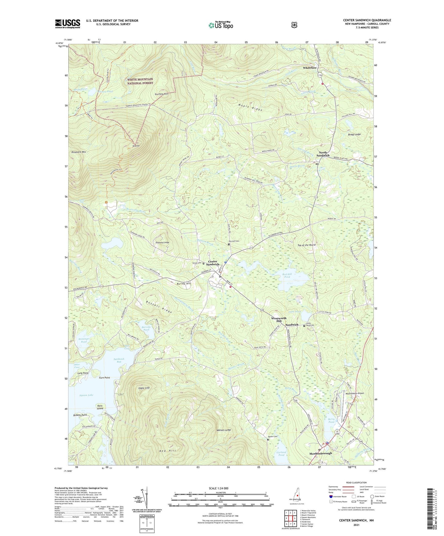
2021 topographic map quadrangle Center Sandwich in the state of New Hampshire. Scale: 1:24000. Based on the newly updated USGS 7.5' US Topo map series, this map is in the following counties: Carroll. The map contains contour data, water features, and other items you are used to seeing on USGS maps, but also has updated roads and other features. This is the next generation of topographic maps. Printed on high-quality waterproof paper with UV fade-resistant inks.
Quads adjacent to this one:
West: Squam Mountains
Northwest: Waterville Valley
North: Mount Tripyramid
Northeast: Mount Chocorua
East: Tamworth
Southeast: Melvin Village
South: Center Harbor
Southwest: Holderness
Contains the following named places: Barville Pond, Beede Falls, Berry Pond, Big Rock Corner, Black Mountain Pond Trail, Bragg Ledge, Browns Point, Burley Hill, Burrows Brook, Buzzell Ridge, Camp Hale, Center Sandwich, Center Sandwich Census Designated Place, Center Sandwich Historic District, Center Sandwich Post Office, Chicks Corner, Cook Brook, Diamond Ledge, Dinsmore Mountain, Dinsmore Pond, Eagle Cliff, Elm Hill Cemetery, Federated Church, Fore Point, Free Will Baptist Church, Garland Pond, Grove Cemetery, Guinea Hill, Guinea Pond, Guinea Pond Trail, Hale Cove, Heath Brook, Kent Island, Kusumpe Pond, Little Pond, Little Pond Cemetery, Lower Corner Historic District, Maple Ridge, Mason Cemetery, Mead Trail, Mead Wilderness Base Organization Camp, Montgomery Brook, Moultonboro Airport, Moultonboro United Methodist Church, Moultonborough, Moultonborough Academy High School, Moultonborough Academy Middle School, Moultonborough Fire and Rescue, Moultonborough Police Department, Moultonborough Post Office, Mount Israel, North Sandwich, North Sandwich Post Office, Otter Cove, Pond Brook, Red Hill, Red Hill Pond, Red Hill State Lookout Tower, Sandwich, Sandwich Bay, Sandwich Central School, Sandwich Fairgrounds, Sandwich Fire Rescue Department Central Station, Sandwich Fire Rescue Department White Face Station, Sandwich Landing, Sandwich Police Department, Sandwich Post Office, Skinner Brook, Stanton Brook, Teacup Lake, Thompson Sanctuary, Tilton Brook, Top of the World, Town of Sandwich, Watson Ledge, Weed Brook, Wentworth Hill, Wentworth Trail, White Church, Whiteface, Whiteface River, ZIP Code: 03227