MyTopo
Milford New Hampshire US Topo Map
Couldn't load pickup availability
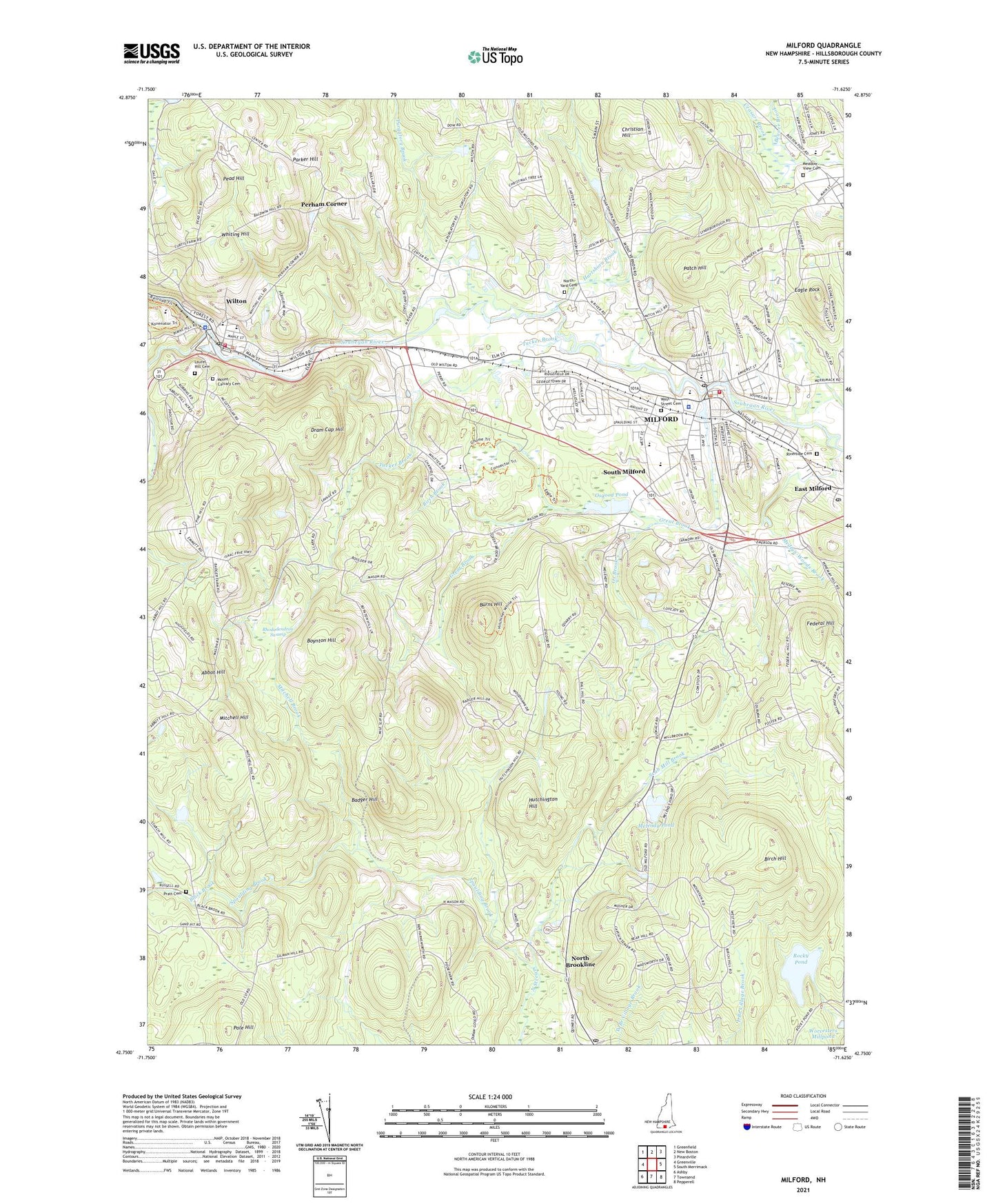
2021 topographic map quadrangle Milford in the state of New Hampshire. Scale: 1:24000. Based on the newly updated USGS 7.5' US Topo map series, this map is in the following counties: Hillsborough. The map contains contour data, water features, and other items you are used to seeing on USGS maps, but also has updated roads and other features. This is the next generation of topographic maps. Printed on high-quality waterproof paper with UV fade-resistant inks.
Quads adjacent to this one:
West: Greenville
Northwest: Greenfield
North: New Boston
Northeast: Pinardville
East: South Merrimack
Southeast: Pepperell
South: Townsend
Southwest: Ashby
Contains the following named places: Abbot Hill, Abbott Memorial Trust Dam, Amherst, Amherst Middle School, Amherst Town Hall, Amherst Town Library, Amherst Village Historic District, Badger Hill, Bates School, Birch Brook, Birch Hill, Black Brook, Boynton Hill, Brookline Post Office, Burns Hill, Ceasars Brook, Christian Hill, Christian Life Assembly of God Church, Church of Our Saviour Episcopal Church, Clark Elementary School, Curtis Corner, Curtiss Dogwood State Park, Dram Cup Hill, Eagle Rock, East Milford, Endicott Park, Federal Hill, Field and Stream Travel Trailer Park, First Congregational Church, Florence Rideout Elementary School, Gardner Street School, Great Brook, Hartshorn Brook, Hartshorn Pond, Heron Pond Elementary School, High Mowing School, Hillsborough Mills Dam, Household of Faith Church, Hutchington Hill, Jacques Memorial Elementary School, Laurel Hill Cemetery, Meadow View Cemetery, Medlyn-Woods Brook, Melendy Pond, Messiah Lutheran Church, Milford, Milford Ambulance Service, Milford Census Designated Place, Milford Christian Academy, Milford City Hall, Milford Elementary School, Milford Fire Department, Milford First Baptist Church, Milford Fish Hatchery, Milford High School and Applied Technology Center, Milford Middle School, Milford Police Department, Milford Post Office, Milford Town Dam, Milford Town Hall, Milford Twin Drive-In, Milford United Methodist Church, Milford-Amherst Area Chamber of Commerce, Mitchell Brook, Mitchell Hill, Mitchell Hill Road, Mount Calvary Cemetery, North Brookline, North Yard Cemetery, Osgood Pond, Osgood Pond Dam, Ox Brook, Parker Hill, Patch Hill, Pead Hill, Perham Corner, Pine Hill Waldorf School, Pole Hill, Pratt Cemetery, Purgatory Brook, Rhododendron Swamp, Richardson, Riverside Cemetery, Rocky Pond, Sacred Heart Church, Sage School, Saint Patricks Roman Catholic Church, Scab Mill Brook, Second Congregational Church, Shanklin Heliport, Souhegan River Reservoir, Souhegan River Watershed Dam Number 33, South Milford, Spaulding Brook, Stony Brook, The Congregational Church of Amherst, Town of Milford, Tucker Brook, Union Square, Unitarian Universalist Church, Wadleigh Memorial Library, Whiting Hill, Wilkins Elementary School, Wilton, Wilton - Lyndeborough Cooperative Middle and High School, Wilton Census Designated Place, Wilton Fire Department, Wilton Police Department, Wilton Post Office, Wilton Town Hall, Wilton-Lyndeboro Middle School, Worcesters Millpond, ZIP Code: 03055