MyTopo
Penacook New Hampshire US Topo Map
Couldn't load pickup availability
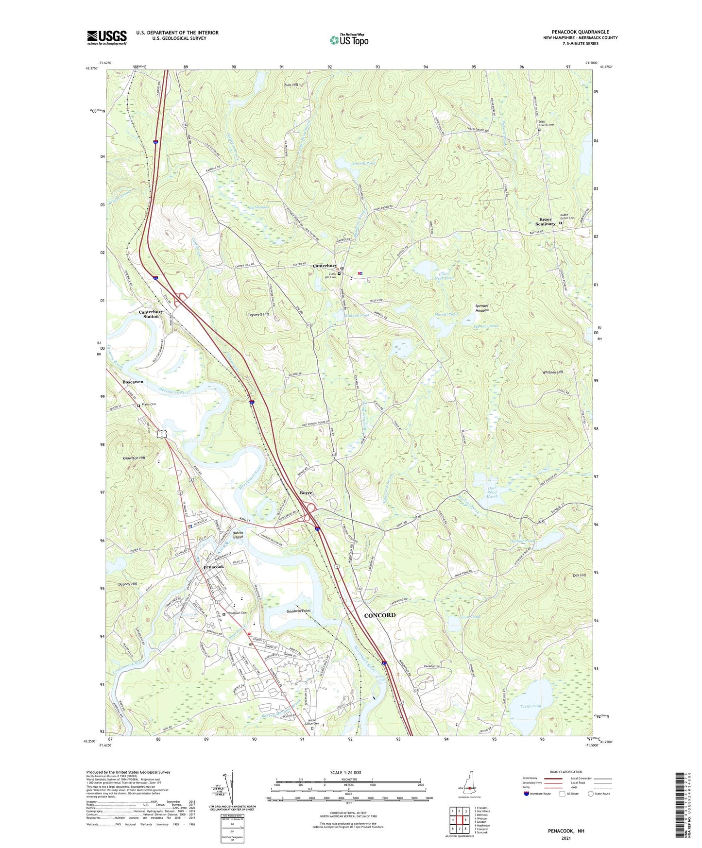
2024 topographic map quadrangle Penacook in the state of New Hampshire. Scale: 1:24000. Based on the newly updated USGS 7.5' US Topo map series, this map is in the following counties: Merrimack. The map contains contour data, water features, and other items you are used to seeing on USGS maps, but also has updated roads and other features. This is the next generation of topographic maps. Printed on high-quality waterproof paper with UV fade-resistant inks.
Quads adjacent to this one:
West: Webster
Northwest: Franklin
North: Northfield
Northeast: Belmont
East: Loudon
Southeast: Suncook
South: Concord
Southwest: Hopkinton
This map covers the same area as the classic USGS quad with code o43071c5.
Contains the following named places: Access Emergency Medical Services, Apple Hill Farm, Beaver Meadow Brook, Beaver Meadow Golf Course, Beaver Meadow School, Big Meadows, Blanchard School, Boscawen, Boscawen Congregational Church, Boscawen Elementary Preschool, Boscawen Elementary School, Boscawen Police Department, Boscowen Main Library, Boyce, Briar Hydro Penstock Intake Dam, Briar Pipe Dam, Burnham Brook, Burnham Brook Middle School, Canterbury, Canterbury Childrens Center, Canterbury Elementary School, Canterbury Police Department, Canterbury Post Office, Canterbury Station, Canterbury Volunteer Fire Department, Carter School, Cogswell Hill, Cold Brook, Competencies Skills Interests Charter School, Concord Fire Department Station, Concord Manor, Contoocook Park, Contoocook River, Contoocook River Reservoir, Crane Neck Pond, Dagody Hill, Davis Brook, Dustin Island, Edward H York Dam, Elgin Kirby Ski Area, Elkins Public Library, Fifield Farm Pond, Fifield Farm Pond Dam, First Baptist Church, Forest Pond Brook, Goodwin Point, Great Brook Farm, Hackett Brook, Hackleboro Orchards, Hannah Duston Memorial State Historic Site, Hayward Brook, Hazleton Brook, Hoit Road Marsh, Hoit Road Marsh Dam, Holt Road Marsh, Holt Road Marsh State Wildlife Manangement Area, Horseshoe Pond, Hothole Pond, Hoyl Brook, Kezer Seminary, Kimball Pond, Main Street School, Maple Grove Cemetery, Merrimack River Reservoir, Merrimack Valley High School, Merrimack Valley Learning Center, Merrimack Valley Middle School, Montessori Children's Center, Morrill Pond, New Hampshire Art Association, Oak Hill, Penacook, Penacook Elementary School, Penacook Post Office, Penacook Rescue Squad, Plains Cemetery, Plains School, Rolfe Park, Saint Marys Episcopal Church, Sewalls Falls, Sewalls Falls Dam, Shaker Road School, Shell Church Cemetery, Snow Pond, Spender Meadow, Spender Pond, Tannery Brook, Town of Canterbury, Turtle Pond, Turtle Pond Dam, United Church of Penacook, Whitney Hill, WJYY-FM (Concord), Woodlawn Cemetery, YMCA Camp, Zion Hill, Zions Hill Cemetery, ZIP Code: 03224