MyTopo
Bridgeton New Jersey US Topo Map
Couldn't load pickup availability
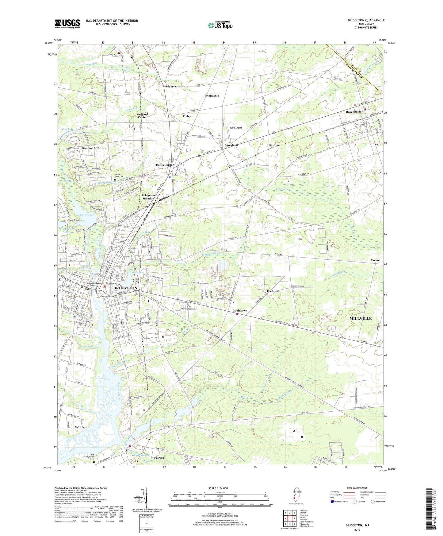
2023 topographic map quadrangle Bridgeton in the state of New Jersey. Scale: 1:24000. Based on the newly updated USGS 7.5' US Topo map series, this map is in the following counties: Cumberland, Salem. The map contains contour data, water features, and other items you are used to seeing on USGS maps, but also has updated roads and other features. This is the next generation of topographic maps. Printed on high-quality waterproof paper with UV fade-resistant inks.
Quads adjacent to this one:
West: Shiloh
Northwest: Alloway
North: Elmer
Northeast: Newfield
East: Millville
Southeast: Dividing Creek
South: Cedarville
Southwest: Ben Davis Point
This map covers the same area as the classic USGS quad with code o39075d2.
Contains the following named places: Adult Learning Center School, Big Oak, Bluebird Branch, Bridgeton, Bridgeton Christian School, Bridgeton City Fire Department, Bridgeton City Park, Bridgeton Inspira Health Center, Bridgeton Junction, Bridgeton Police Department, Bridgeton Post Office, Bridgeton Senior High School, Broad Street Elementary School, Bucks Airport, Buckshutem Road Elementary School, Carlls Corner, Carlls Corner Census Designated Place, Carmel Volunteer Fire Company, Cherry Street Elementary School, City of Bridgeton, City of Bridgeton Heliport, City Park, Clarks Pond, Clarks Pond Dam, Clarks Pond Fish and Wildlife Management Area, Cohansey Country Club, Cornwell Run, Cumberland County Department of Corrections, Cumberland County Sheriff, Cumberland County Technical Education Center School, Cumberland Regional High School, Deerfield Township School, Dutch Neck, East Lake, East Lake Dam, Eddy Pond, Fairfield Township Elementary School, Fairfield Township Volunteer Fire Company 1, Fairton, Fairton Census Designated Place, Fairton Christian Center, Fairton Post Office, Federal Correctional Institution - Fairton, Federal Correctional Institution - Fairton Satellite Camp, Finley, Fordville, Foster Run, Friendship, Friendship Church, Garton, Geraldyn O Foster Early Childhood Center Preschool, Gouldtown, Gouldtown Census Designated Place, Gouldtown Fire Department Fairfield Township Fire Company 2, Immaculate Conception School, Indian Avenue Elementary School, Indian Fields Branch, Island Branch, Jackson Run, Lakeside-Beebe Run Census Designated Place, Laurel Heights, Laurel Heights Census Designated Place, Laurel Lawn Cemetery, Li Calzi Airport, Loper Run, Maple Hollow Branch, Maranatha Baptist School, Mary Elmer Lake Dam, Mill Creek, Muddy Run, Nanticoke Lenni Lenape State Designated Tribal Statistical Area, New Jersey State Police Troop A Bridgeton Road Station, North Cape May Branch, Old Presbyterian Cemetery, Orchard Center, Pineland Learning Center Elementary School, Piney Point, Quarter Mile Lane Elementary School, Rammel Mill, Rocaps Run, Rosenhayn, Rosenhayn Census Designated Place, Rosenhayn Fire and Rescue, Rosenhayn Post Office, Saint Marys Church, Seeley Census Designated Place, Shaw Branch, Silver Lake, Silver Lake Census Designated Place, Silver Lake Dam, South Jersey Hospital System Heliport, South Woods State Prison, Sunset Lake, Sunset Lake Census Designated Place, Sunset Lake Dam, Tindells Landing, Township of Deerfield, Township of Upper Deerfield, Upper Deerfield Emergency Medical Services, Upper Deerfield Preschool, Upper Deerfield Township Fire Company Station 2 Seabrook Fire and Rescue, Upper Deerfield Township Fire Company Station 3 Carlls Corner, West Avenue Elementary School, Woodruff, WSNJ-AM (Bridgeton), WSNJ-FM (Bridgeton), ZIP Codes: 08320, 08352