MyTopo
Cedarville New Jersey US Topo Map
Couldn't load pickup availability
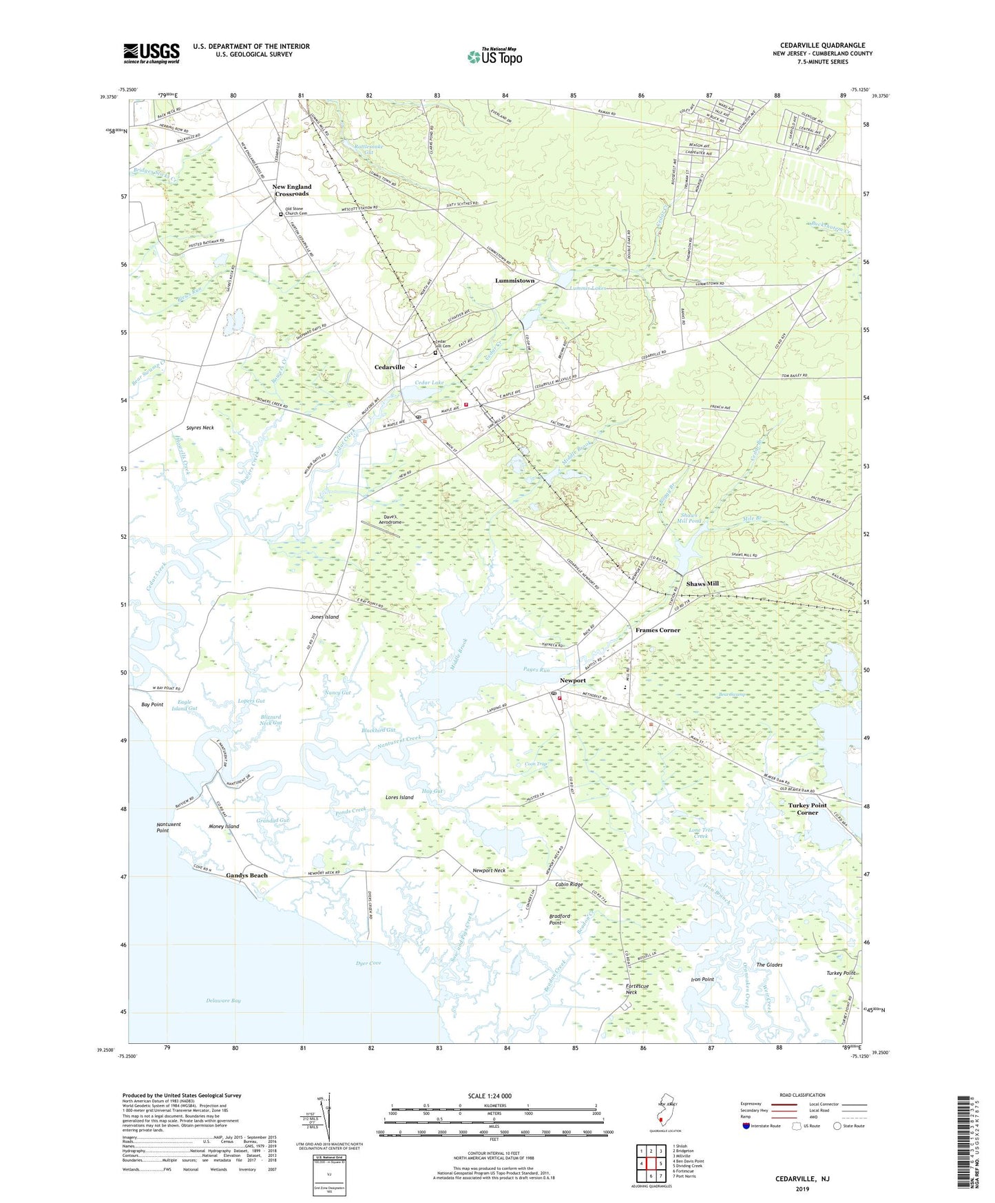
2023 topographic map quadrangle Cedarville in the state of New Jersey. Scale: 1:24000. Based on the newly updated USGS 7.5' US Topo map series, this map is in the following counties: Cumberland. The map contains contour data, water features, and other items you are used to seeing on USGS maps, but also has updated roads and other features. This is the next generation of topographic maps. Printed on high-quality waterproof paper with UV fade-resistant inks.
Quads adjacent to this one:
West: Ben Davis Point
Northwest: Shiloh
North: Bridgeton
Northeast: Millville
East: Dividing Creek
Southeast: Port Norris
South: Fortescue
This map covers the same area as the classic USGS quad with code o39075c2.
Contains the following named places: Beach Creek, Bear Swamp, Beaver Dam, Blackbird Gut, Blizzard Neck Gut, Boggy Branch, Bowers Creek, Bradford Point, Cabin Ridge, Cedar Branch, Cedar Hill Cemetery, Cedar Lake, Cedar Lake Dam, Cedarville, Cedarville Census Designated Place, Cedarville Fire Department Station 17, Cedarville Post Office, Centre Grove Census Designated Place, Coon Trap, Cumberland County, Dave's Aerodrome, Downe Township Ambulance, Downe Township Elementary School, Downe Township Fire and Rescue Newport Volunteer Fire Department, Dyer Cove, Dyer Creek, Eagle Island Gut, Fortescue Fish and Wildlife Management Area, Fortescue Island, Fortescue Neck, Frames Corner, Gandys Beach, Gandys Beach Census Designated Place, Grandad Gut, Hay Gut, Hollywood Beach, Howells Creek, Iron Branch, Iron Point, Jones Island, Lawrence Township Emergency Medical Services, Little Pond Creek, Lone Tree Creek, Lopers Gut, Lores Island, Lummis Lake Lower Dam, Lummis Lakes, Lummistown, Middle Brook, Mile Branch, Money Island, Money Island Census Designated Place, Myron L Powell Elementary School, Nancy Gut, Nantuxent Creek, Nantuxent Fish and Wildlife Management Area, Nantuxent Point, New England Crossroads, Newport, Newport Census Designated Place, Newport Landing, Newport Neck, Newport Post Office, Old Stone Church Cemetery, Padgetts Creek, Pages Run, Ponds Creek, Rattlesnake Gut, Shaws Mill, Shaws Mill Pond, Shaws Mill Pond Dam, Sheepkill Pond, Sow and Pigs Creek, The Glades, Township of Downe, Township of Fairfield, Township of Lawrence, Turkey Point, Turkey Point Corner, Wallens Pond, Watsons Corner, Weir Creek, ZIP Codes: 08311, 08345