MyTopo
Tuckerton New Jersey US Topo Map
Couldn't load pickup availability
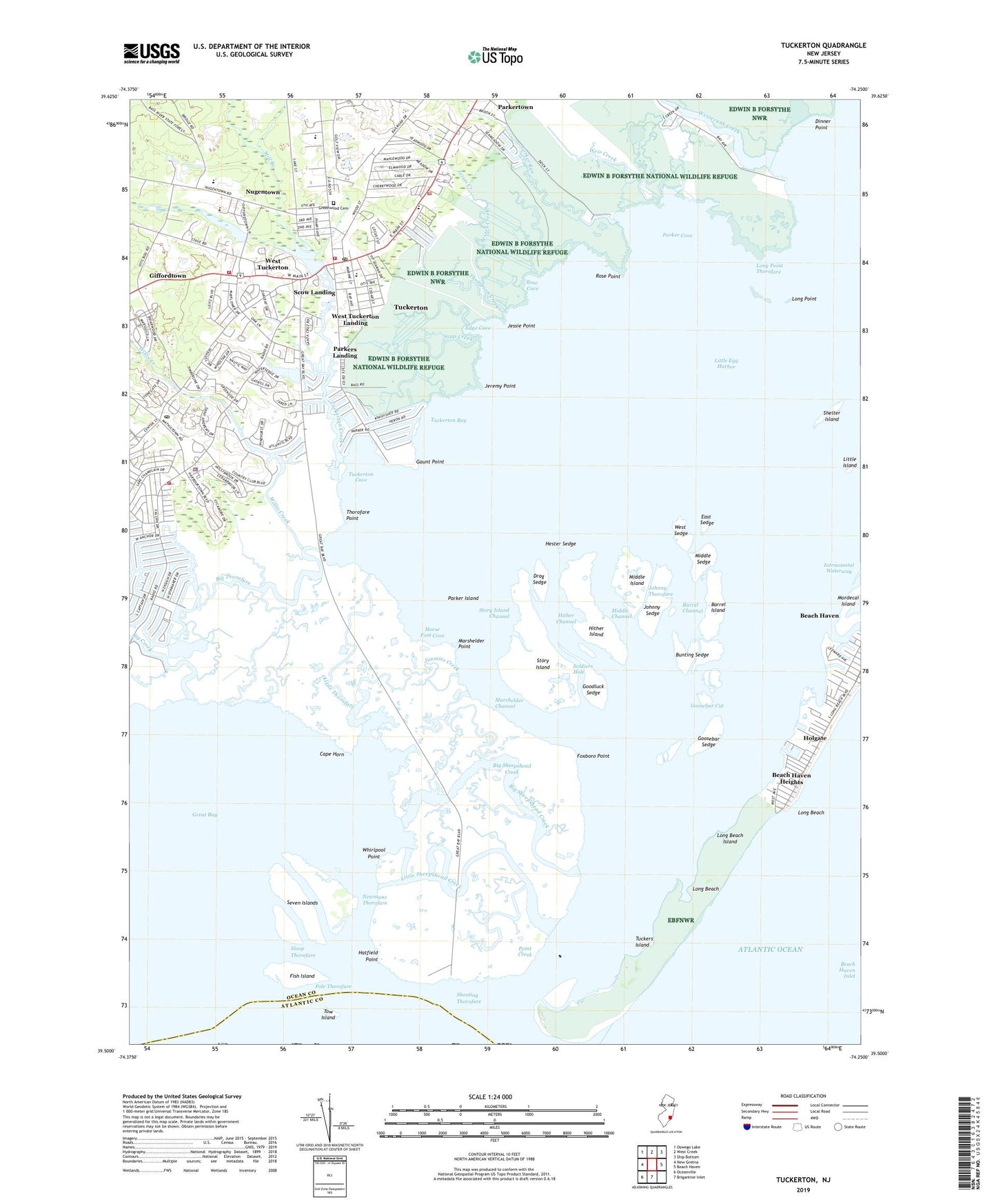
2023 topographic map quadrangle Tuckerton in the state of New Jersey. Scale: 1:24000. Based on the newly updated USGS 7.5' US Topo map series, this map is in the following counties: Ocean, Atlantic. The map contains contour data, water features, and other items you are used to seeing on USGS maps, but also has updated roads and other features. This is the next generation of topographic maps. Printed on high-quality waterproof paper with UV fade-resistant inks.
Quads adjacent to this one:
West: New Gretna
Northwest: Oswego Lake
North: West Creek
Northeast: Ship Bottom
East: Beach Haven
South: Brigantine Inlet
Southwest: Oceanville
This map covers the same area as the classic USGS quad with code o39074e3.
Contains the following named places: Barrel Channel, Barrel Island, Beach Haven Heights, Big Creek, Big Sheepshead Creek, Big Thorofare, Borough of Tuckerton, Bunting Sedge, Bureau of Fire Safety, Cape Horn, Coastal Learning Center Day School, Dinner Point, Dinner Point Creek, Drag Sedge, East Sedge, Edge Cove, Edwin B Forsythe National Wildlife Refuge, Fish Island, Flatteras Creek, Foxboro Point, Gaunt Point, George J Mitchell Elementary School, Giffords Mill Branch, Giffordtown, Goodluck Sedge, Goosebar Cut, Goosebar Sedge, Great Bay Boulevard State Wildlife Management Area, Great Bay Regional Volunteer Emergency Medical Services, Greenwood Cemetery, Hatfield Creek, Hatfield Point, Hester Sedge, Hither Channel, Hither Island, Holgate, Horse Foot Cove, Jeremy Point, Jesses Creek, Jessie Point, Jimmies Creek, Johnny Sedge, Johnny Thorofare, Little Egg Harbor, Little Egg Harbor Post Office, Little Egg Harbor Township Police Department, Little Island, Little Sheepshead Creek, Little Thorofare, Long Point, Long Point Thorofare, Marshelder Channel, Marshelder Point, Middle Channel, Middle Island, Middle Sedge, Mill Branch, Mordecai Island, Mystic Island Volunteer Fire Department Station 72, Newmans Thorofare, Nugentown, Ocean County Golf Course at Atlantis, Parker Cove, Parker Island, Parker Run, Parkers Landing, Parkertown County Park, Pinelands Regional High School, Pinelands Regional Junior High School, Pohatcong Lake, Point Creek, Pole Thorofare, Pulaski Monument, Rose Cove, Rose Point, Sapp Creek, Scow Landing, Seven Islands, Shelter Island, Shooting Thorofare, Sloop Thorofare, Soldiers Hole, Story Island, Story Island Channel, Thompson Creek, Thorofare Point, Tow Island, Township of Little Egg Harbor, Tuckers Island, Tuckerton, Tuckerton Bay, Tuckerton Borough Police Department, Tuckerton Cove, Tuckerton Creek, Tuckerton Elementary School, Tuckerton Fire Department, Tuckerton Post Office, Tuckerton Shores, WACI-TV (Atlantic City), Weir Creek, West Sedge, West Tuckerton, West Tuckerton Landing, West Tuckerton Volunteer Fire Company Station 71, Westecunk Creek, Whirlpool Point, Willis Creek, ZIP Code: 08008