MyTopo
Lordsburg New Mexico US Topo Map
Couldn't load pickup availability
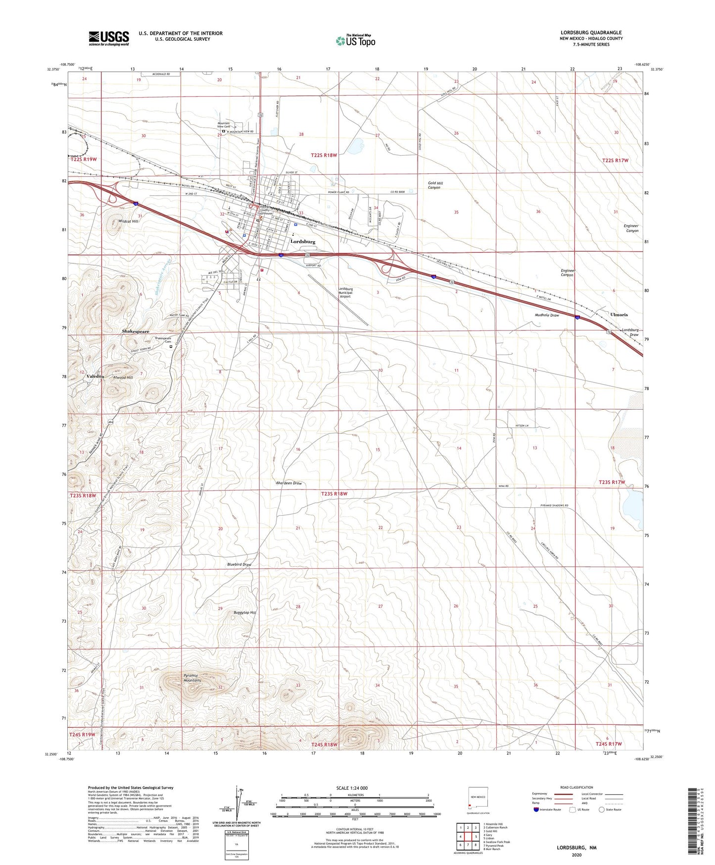
2023 topographic map quadrangle Lordsburg in the state of New Mexico. Scale: 1:24000. Based on the newly updated USGS 7.5' US Topo map series, this map is in the following counties: Hidalgo. The map contains contour data, water features, and other items you are used to seeing on USGS maps, but also has updated roads and other features. This is the next generation of topographic maps. Printed on high-quality waterproof paper with UV fade-resistant inks.
Quads adjacent to this one:
West: Gary
Northwest: Ninemile Hill
North: Culberson Ranch
Northeast: Gold Hill
East: Lisbon
Southeast: Muir Ranch
South: Pyramid Peak
Southwest: Swallow Fork Peak
This map covers the same area as the classic USGS quad with code o32108c6.
Contains the following named places: 10006 Water Well, 10007 Water Well, Aberdeen Draw, Abundant Life Fellowship Inc, Apostolic Church, Assembly of God Church, Atwood Hill, Atwood Mine, Barney Stage Station, Bessie, Bluebird Draw, Bluebird Mine, Brown Windmill, Buena Vista Pentecostal Church, Buggytop Hill, Central Elementary School, Church of Christ, City of Lordsburg, Copper Reef Group Mine, Cornelia I and Emma I Mine, Dewey Lode, Dry Town Lode, Durran-Tarango Middle School, Family Life Church, First Assembly of God Church, First Baptist Church, First United Methodist Church, Florence Lode, General Jerry Boyle, Gold Hill Canyon, Green Copper, Green King Windmill, Henry Clay Mine, Hidalgo County Ambulance and Emergency Medical Services, Hidalgo County Courthouse Historic Site, Hidalgo County Fire Department District 1, Hidalgo County Sheriff's Office, Hidalgo Hotel, Hughes Windmill, Iglesia Apostolica de la Fe, Judita Group, Kennedy Windmill, Kingfisher, KXKK-FM (Lordsburg), Lady Mary, Lady Mary Mine, Lone Star Prospect, Lordsburg, Lordsburg Army Air Field, Lordsburg Church of Christ, Lordsburg Coaling Tower Historic Site, Lordsburg High School, Lordsburg Historical Marker, Lordsburg Municipal Airport, Lordsburg Police Department, Lordsburg Post Office, Lordsburg Volunteer Fire Department, Lordsburg Weather Station, Metropolis Group, Monrovia Lode, Mountain View Cemetery, Mudhole Draw, Napoleon and Belle Tower Lode, Nevada Lode, New Mexico State Police District 12 Lordsburg, Oakland Lode, Oil Siding, Pyramid Tabernacle, R V Elementary School, Robson Windmill, Rosemary Lode, Ruth, Ruth Mine, Scripture Baptist Church, Shakespeare, Shakespeare Arroyo, Shakespeare Cemetery, Shakespeare Historical Marker, Short Park, South Side Elementary School, Southern Lode, The Church of Jesus Christ of Latter Day Saints, Triangle Lode, Ulmoris, Valedon, Valedon Mine, Valedon Post Office, Waldo Mine, Wildcat Hill, Woods Ranch, Yellow Jacket