MyTopo
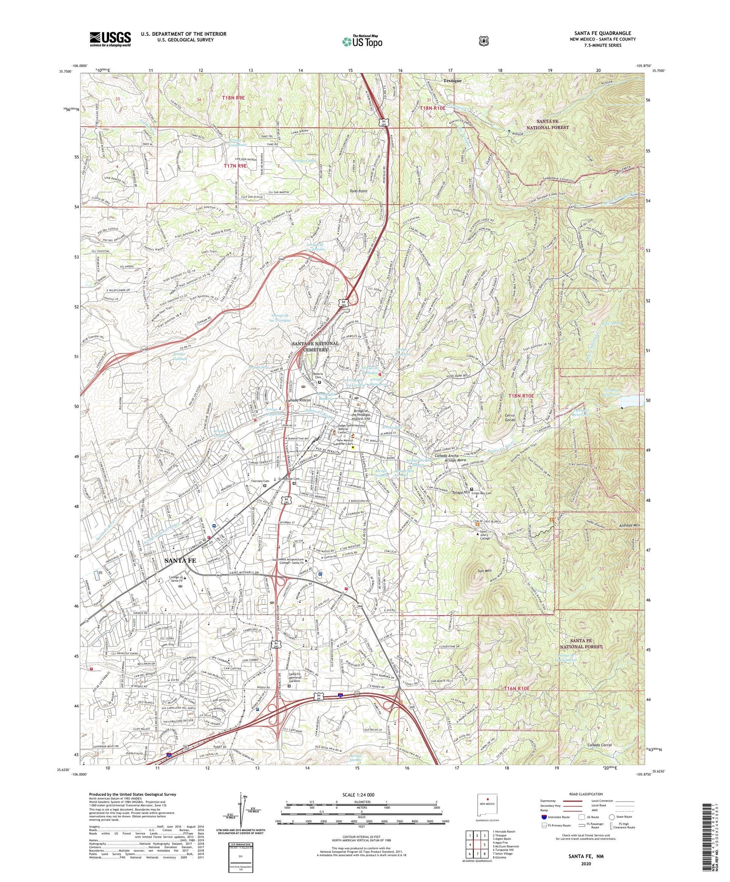
Santa Fe New Mexico US Topo Map
Couldn't load pickup availability
Also explore the Santa Fe Forest Service Topo of this same quad for updated USFS data
2023 topographic map quadrangle Santa Fe in the state of New Mexico. Scale: 1:24000. Based on the newly updated USGS 7.5' US Topo map series, this map is in the following counties: Santa Fe. The map contains contour data, water features, and other items you are used to seeing on USGS maps, but also has updated roads and other features. This is the next generation of topographic maps. Printed on high-quality waterproof paper with UV fade-resistant inks.
Quads adjacent to this one:
West: Agua Fria
Northwest: Horcado Ranch
North: Tesuque
Northeast: Aspen Basin
East: McClure Reservoir
Southeast: Glorieta
South: Seton Village
Southwest: Turquoise Hill
This map covers the same area as the classic USGS quad with code o35105f8.
Contains the following named places: 10032 Water Well, 10042 Water Well, 10044 Water Well, 10048 Water Well, 10049 Water Well, 10059 Water Well, 10101 Water Well, 10102 Water Well, 10105 Water Well, 10226 Water Well, 10241 Water Well, Acequia de los Pinos, Acequia Madre Elementary School, Acequie Madre, Agua Fria Elementary School, Amelia White Park, Analco, Andreas Kopp House, Arroyo Barranca, Arroyo de la Piedra, Arroyo de los Lovatos, Arroyo del Rosario, Arroyo Mascaras, Arroyo Mora, Arroyo Ranchito, Arroyo Saiz, Arroyo San Antonio, Arroyo Seco, Arroyo Tenorio, Arroyo Tierra Blanca, Arroyo Torreon, Ashbaugh Park, Atalaya Mountain, Atalaya Park, Atalaya Trail, Atchison Topeka and Santa Fe Railway Depot Locomotive 5030 Historic Site, Aztec Spring, Aztec Springs Creek, Barrio de Analco Historic District, Bishops Lodge, Bridge of the Hidalgos Historic Site, Camino del Monte Sol Historic District, Canada Ancha, Canada Corral, Canada Rincon, Candelero Park, Cerro Gordo, Cerro Gordo Park, CHRISTUS Saint Vincent Orthopedics and Sports Institute, Christus Saint Vincent Regional Medical Center, City of Santa Fe, Conejo Census Designated Place, Conklin Estate, Cornell Park, Cristo Rey Cemetery, Cristo Rey School, De Vargas Park, Don Gaspar Historic District, E J Martinez Elementary, Fairview Cemetery, Footbridges Park, Fort Marcy, Fort Marcy Park, Four Mile Reservoir, Francis X Nava Elementary School, Frank S Ortiz Park, General Franklin E Miles Park, Governors Residence Heliport, Gregory Lopez Park, Guadalupe Cemetery, Herb Martinez Park, Hillside Park, HLCX STRT Water Well, Hyde Park Census Designated Place, Hyde Park Estates, Ind School Water Well, John F Ray Griego Park, Jose Antonio House, KKOB-AM (Santa Fe), KSFR-FM (Santa Fe), KSWV-AM (Santa Fe), KTRC-AM (Santa Fe), KVSF-AM (Santa Fe), La Casita Pre School, Laboratory of Anthropology, Larragoite Park, Larrangoite Residence, Little Tesuque Creek, Magers Field, Martyrs Cross, Monica Lucero Park, Mountain View School, Nichols Dam, Nichols Reservoir, Nizhoni School, O'Bannon Field, Orlando Fernandez Park, Pinon Elementary School, Pinon Hills Hospital, Pinon Hills Hospital and Training Center, Prince Plaza, R M Sweeny Elementary School, Ragle Park, Rancho la Barbarria, Remuda Christian School, RG-1033 Water Well, RG-11473 Water Well, RG-11611 Water Well, RG-12331 Water Well, RG-14119 Water Well, RG-14162 Water Well, RG-1424 Water Well, RG-14253 Water Well, RG-14379 Water Well, RG-14650 Water Well, RG-14848 Water Well, RG-15189 Water Well, RG-15363 Water Well, RG-15887 Water Wells, RG-15901 Water Well, RG-16043 Water Well, RG-16304 Water Well, RG-16411 Water Well, RG-16627 Water Well, RG-1664 Water Well, RG-17187 Water Well, RG-17218 Water Well, RG-17744 Water Well, RG-17813 Water Well, RG-18385 Water Well, RG-18831 Water Well, RG-20388 Water Well, RG-21017 Water Well, RG-2279 Water Well, RG-22842 Water Well, RG-2307-10 Water Well, RG-23130 Water Well, RG-25115 Water Well, RG-25406 Water Well, RG-27066 Water Well, RG-2745 Water Well, RG-27732 Water Well, RG-27862 Water Well, RG-28453 Water Well, RG-28465 Water Well, RG-28492 Water Well, RG-28712 Water Well, RG-288 Water Well, RG-29042 Water Well, RG-29142 Water Well, RG-304 Water Well, RG-3051 Water Well, RG-30564 Water Well, RG-3624 Water Well, RG-4082 Water Well, RG-4250 Water Well, RG-559 Water Well, RG-625 Water Well, RG-626 Water Well, RG-647 Water Well, RG-651 Water Well, RG-654 Water Well, RG-656 Water Well, RG-658 Water Well, RG-661 Water Well, RG-7904 Water Well, RG-804 Water Well, RG-8710 Water Well, Rio Grande School, Rio Valle Recover center, Rosario Cemetery, Saint Anne Elementary School, Saint Johns College Helispot, Saint Johns Trail, Saint Michaels High School, Saint Vincent Hospital Heliport, Salvador Gonzales, Salvador Perez Park, Santa Fe, Santa Fe Archery Club, Santa Fe Division, Santa Fe Fast Base, Santa Fe Foothills Census Designated Place, Santa Fe Grant, Santa Fe Historic District, Santa Fe Manganese District, Santa Fe Memorial Gardens, Santa Fe National Cemetery, Santa Fe Pre School, Santa Fe Preparatory School, Santa Fe River Park, Santa Fe River Park East, Santa Fe River Park West, Santa Fe River State Park, Santa Fe Service Unit Indian Health Service Hospital, Santa Fe Weather Station, Santa Rosa High School, Santa Waldorf School, Sena Plaza, Sequoia Preparatory School, SF-1A Water Well, SF-1B Water Well, SF-1C Water Well, Small World Learning Center, Sol y Sombra, Southridge Calle Lorca Park, Sun Mountain, Talaya Hill, Talaya Hill Grant, Talaya Hill Reservoir, Tano Point, Tano Road, Tano Road Census Designated Place, Temple Baptist School, Temple Beth Shalom School, Tesuque Census Designated Place, Tesuque Creek, The Brunn School, The Gentle Nudge School, The Montressori Childrens House Odyssey Montressori Elementary, The Santa Fe Plaza National Historic Landmark, The Tutorial School, Torreon Park, Torreon Water Well, Turquoise Trail Elementary School, Twin Spirit Rivers School, Two Mile Reservoir Dam, Twomile Reservoir, Water Well 1, Water Well 1A, Water Well 2, Water Well 44, Willow Valley School, Wood-Gormley Elementary School, Young Park