MyTopo
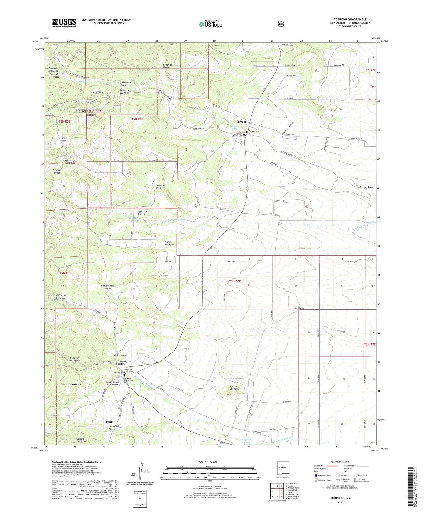
Torreon New Mexico US Topo Map
Couldn't load pickup availability
Also explore the Torreon Forest Service Topo of this same quad for updated USFS data
2023 topographic map quadrangle Torreon in the state of New Mexico. Scale: 1:24000. Based on the newly updated USGS 7.5' US Topo map series, this map is in the following counties: Torrance. The map contains contour data, water features, and other items you are used to seeing on USGS maps, but also has updated roads and other features. This is the next generation of topographic maps. Printed on high-quality waterproof paper with UV fade-resistant inks.
Quads adjacent to this one:
West: Capilla Peak
Northwest: Bosque Peak
North: Tajique
Northeast: Milbourn Ranch
East: Ewing
Southeast: Mountainair
South: Punta de Agua
Southwest: Manzano Peak
This map covers the same area as the classic USGS quad with code o34106f3.
Contains the following named places: Alexander Place, Anderson Place, Benson Place, Bermadez Place, Brizendine Place, Brown Place, Campo Santo Cemetery, Candelaria Place, Canon de Bartolo, Canon de Cuervo, Canon de la Capilla, Canon de la Vereda, Canon de las Palas, Canon de los Pino Reales, Canon de Novillo, Canon de Torreon, Canon del Agua, Canon del Chato, Canon del Encierro, Canon del Jaral, Canon del Venado, Canon Nuevo, Cerrito del Espia, Cerrito del Llano, Chato, Chaves Place, Comanche Ridge, Hyde Place, Maez Place, Manzano, Manzano Cemetery, Manzano Census Designated Place, Manzano Churchyard Cemetery, Manzano Hills Cemetery, Manzano Post Office, Moorehead Place, Ojo Medio, Pino de la Virgen, Romero Place, Saiz Place, Sanchez Place, Torreon, Torreon Catholic Cemetery, Torreon Cemetery, Torreon Census Designated Place, Torreon Post Office, Torreon Spring, Torreon Volunteer Fire Department, Town of Torreon Grant