MyTopo
Burnt Hills New York US Topo Map
Couldn't load pickup availability
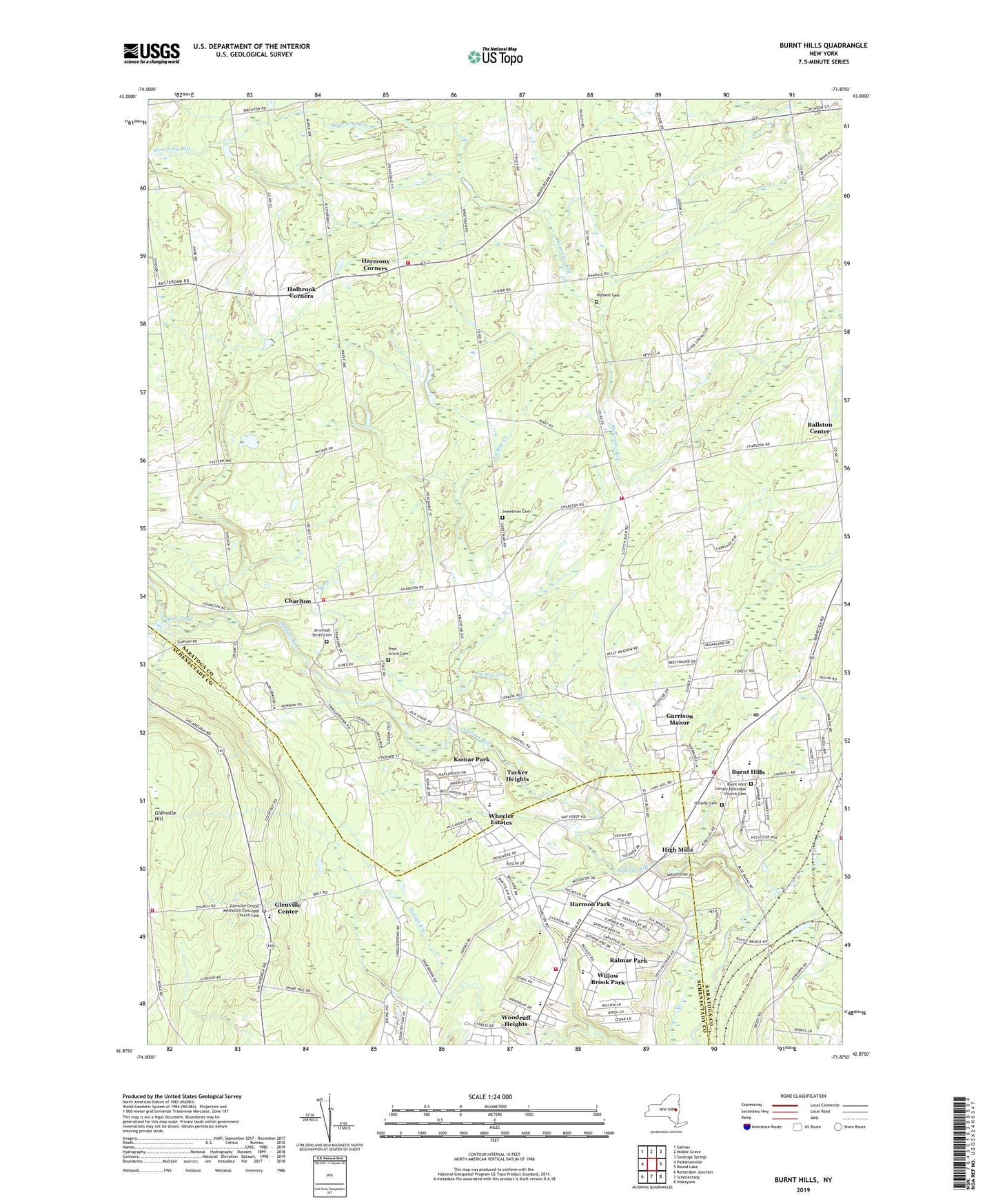
2019 topographic map quadrangle Burnt Hills in the state of New York. Scale: 1:24000. Based on the newly updated USGS 7.5' US Topo map series, this map is in the following counties: Saratoga, Schenectady. The map contains contour data, water features, and other items you are used to seeing on USGS maps, but also has updated roads and other features. This is the next generation of topographic maps. Printed on high-quality waterproof paper with UV fade-resistant inks.
Quads adjacent to this one:
West: Pattersonville
Northwest: Galway
North: Middle Grove
Northeast: Saratoga Springs
East: Round Lake
Southeast: Niskayuna
South: Schenectady
Southwest: Rotterdam Junction
Contains the following named places: Ballston Center Presbyterian Church, Ballston Lake Baptist Church, Ballston Lake Fire Department, Bethany Baptist Church, Burnt Hills, Burnt Hills - Town of Ballston Community Library, Burnt Hills Baptist Church, Burnt Hills Calvary Episcopal Church Cemetery, Burnt Hills Post Office, Burnt Hills United Methodist Church, Burnt Hills Volunteer Fire Department Station 1, Burnt Hills Volunteer Fire Department Station 2, Burnt Hills-Ballston Lake High School, Calvary Episcopal Church, Charlton, Charlton Freehold Presbyterian Church, Charlton Heights Elementary School, Charlton Historical Society Museum, Charlton Road Orchard, Charlton Town Hall, Charlton Volunteer Fire Department, Church of the Immaculate Conception, Clark Dahlia Gardens And Greenhouse, Dungiven Farm, East Glenville, East Glenville Church, East Glenville Fire Department, Francis L Stevens Elementary School, Freedom Farms, Fruitwood Acres, Garrison Manor, Glendaal School, Glendale Nursing Home, Glenville Berry Farm, Glenville Center, Glenville Center Methodist Episcopal Church Cemetery, Glenville Hill, Glenville Hill Volunteer Fire Department, Glindmyer Evergreen Nurseries, Good Shepherd Lutheran Church, Harmon Park, Harmony Corners, Harmony Corners Fire District Station, High Mills, Hillside Cemetery, Hillside Gardens, Holbrook Corners, Hubbell Cemetery, Industrial Farm School, Jeremiah Smith Cemetery, Justamere Farm, Kays Trailer Court, Kingdom Hall of Jehovah's Witnesses, Knight Orchard of Saratoga County, Komar Park, La Rue Creek, Lake Ridge Farms, Mandak Stables, Mourningkill Estates, Mourningkill Farm, Oak Hill School, Orchard Park, Pashley Elementary School, Pine Grove Cemetery, Ralmar Park, Richard H O'Rourke Middle School, Saint Paul's Church, School Number 4, School Number 7, School Number 8, Seeping Springs Farm, Seter Heights Farm, Silver Springs, Smiths Dairy Farm, Sweetman Cemetery, Taylor Pond, Town of Ballston, Town of Charlton, Town of Glenville, Tucker Heights, Vienna Heights, Wheeler Estates, Willow Brook Park, Willow Marsh Farm, Windridge Farm, Woodruff Heights, ZIP Codes: 12019, 12027, 12302