MyTopo
Dover Plains New York US Topo Map
Couldn't load pickup availability
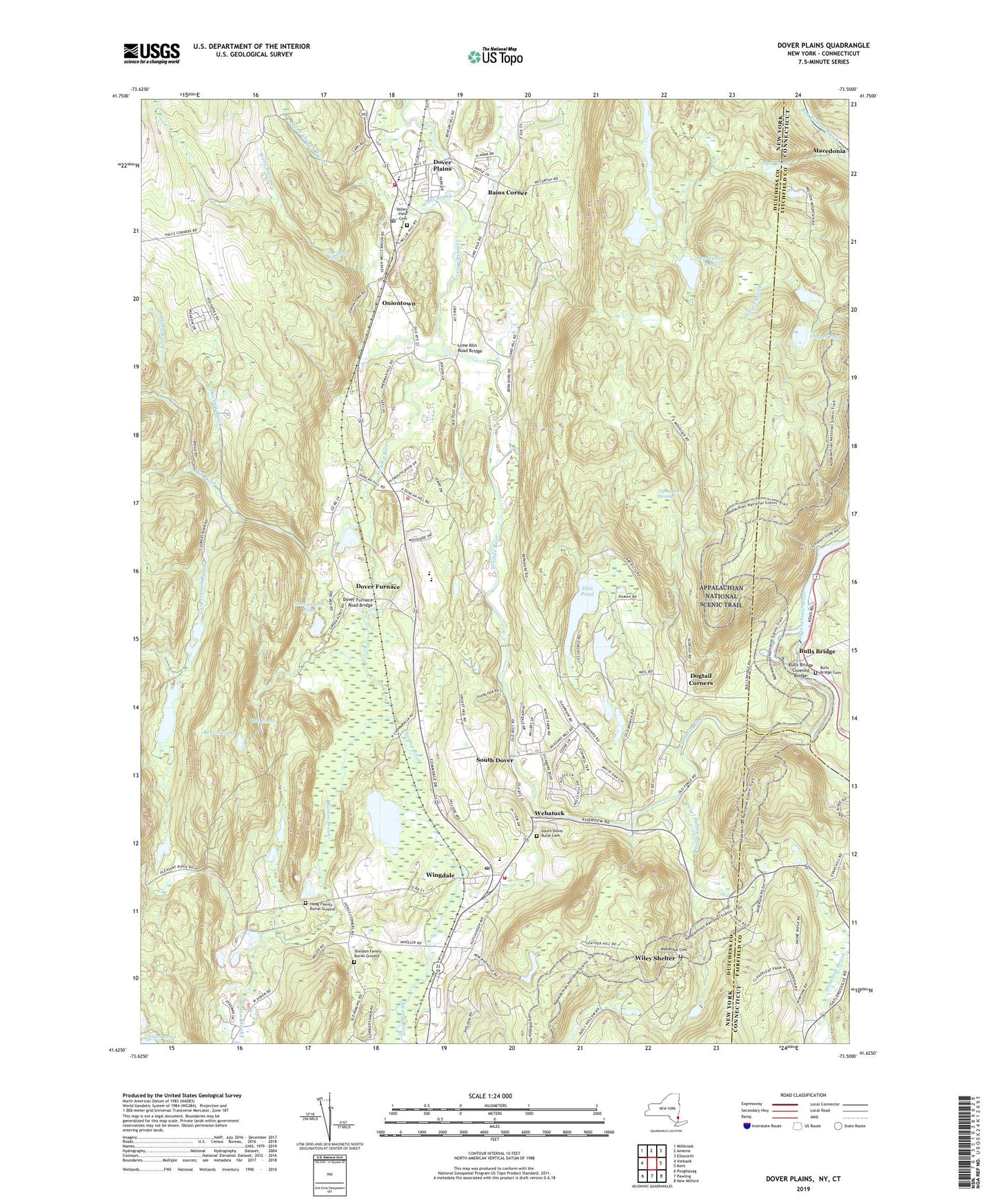
2019 topographic map quadrangle Dover Plains in the states of New York, Connecticut. Scale: 1:24000. Based on the newly updated USGS 7.5' US Topo map series, this map is in the following counties: Dutchess, Litchfield, Fairfield. The map contains contour data, water features, and other items you are used to seeing on USGS maps, but also has updated roads and other features. This is the next generation of topographic maps. Printed on high-quality waterproof paper with UV fade-resistant inks.
Quads adjacent to this one:
West: Verbank
Northwest: Millbrook
North: Amenia
Northeast: Ellsworth
East: Kent
Southeast: New Milford
South: Pawling
Southwest: Poughquag
Contains the following named places: Bains Corner, Bald Mountain, Bear Swamp, Beaver Brook, Bulls Bridge, Bulls Bridge Cemetery, Bulls Bridge Covered Bridge, Bulls Bridge Dam, Bulls Bridge Pond, Burton Brook, Camp Siwanoy, Chapel Pond, Church Hill, Coopertown Brook, Crane Pond, Crystal House Manor Assisted Living Facility, Daver Furnance School, Depression Pond, Deuel Hollow Brook, Dobar Mountain, Doctors Brook, Dogtail Corners, Dover Elementary School, Dover Fire Department J H Ketcham Hose Company Station 2, Dover Fire Department J H Ketchum Hose Company, Dover Fire Department Ketcham Hose Company Station 1, Dover Furnace, Dover Furnace Road Bridge, Dover High School, Dover Middle School, Dover Plains, Dover Plains Census Designated Place, Dover Plains Library, Dover Plains Post Office, Dover Plains Second Baptist Church, Dover Plains Station, Dover Plains United Methodist Church, Dover Town Hall, Duck Pond, East Mountain, East Mountain Farm And Stables, Ellis Pond, Fox Hill, Gardner Hill, Great Thicket National Wildlife Refuge, Harlem Valley Psychiatric Center, Harlem Valley-Wingdale Station, High Plains, Hoag Family Burial Ground, Jewett School, Ketcham Park, Leather Hill, Lime Kiln Road Bridge, Lossing Hill, Lossing School, Mill River, Mullin Hill, Nellie Hill, Oniontown, Ore Pond, Powell Mobile Home Park, Powell Park, Preston Hill, Saint Charles Church, Saint James Episcopal Church, Sawmill Hill, Schaghticoke Mountain, Schaghticoke Reservation, Sharp Hills, Sharparoon Pond, Sheldon Family Burial Ground, South Dover, South Dover Rural Cemetery, Spooner Dam, Spooner Pond, Stone Church Brook, Stony Brook, Swamp River, Tallyho Mobile Home Estates, Tamarack Swamp, Tenmile Hill, Tenmile River, The Seven Wells, The Stone Church, Town of Dover, Valley View Cemetery, Waldo Hill, Webatuck, Webatuck School, Webetuck Cemetery, Wells Brook, West Mountain, White School, Wiley Shelter, Wingdale, Wingdale Census Designated Place, Wingdale Elementary School, Wingdale Post Office, Wingdale Quarry, Wingdale Village Mobile Home Park, ZIP Codes: 12522, 12594