MyTopo
Hudson Falls New York US Topo Map
Couldn't load pickup availability
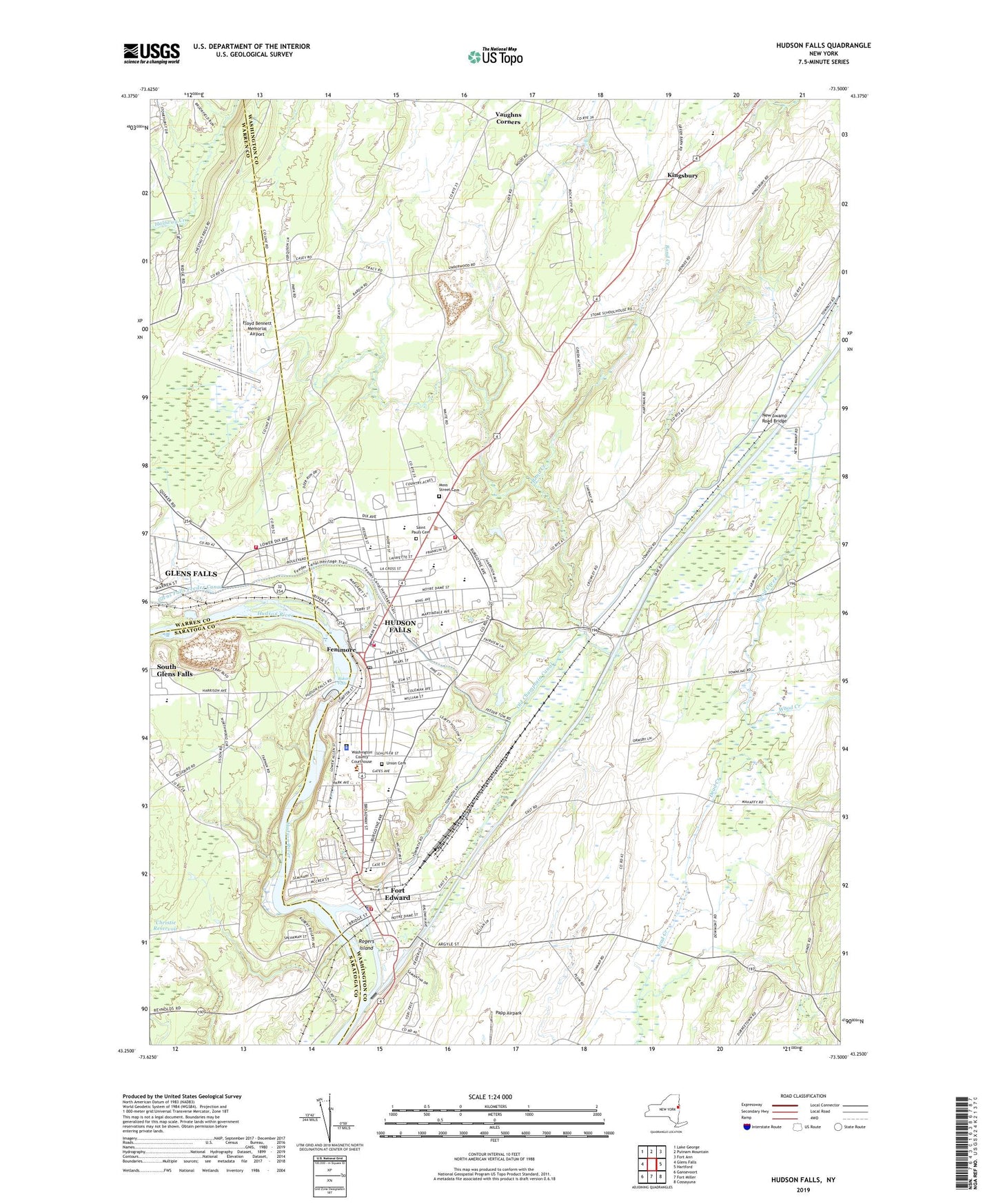
2023 topographic map quadrangle Hudson Falls in the state of New York. Scale: 1:24000. Based on the newly updated USGS 7.5' US Topo map series, this map is in the following counties: Washington, Saratoga, Warren. The map contains contour data, water features, and other items you are used to seeing on USGS maps, but also has updated roads and other features. This is the next generation of topographic maps. Printed on high-quality waterproof paper with UV fade-resistant inks.
Quads adjacent to this one:
West: Glens Falls
Northwest: Lake George
North: Putnam Mountain
Northeast: Fort Ann
East: Hartford
Southeast: Cossayuna
South: Fort Miller
Southwest: Gansevoort
This map covers the same area as the classic USGS quad with code o43073c5.
Contains the following named places: Adirondack Community College, Advent Christian Church, Bakers Falls, Bluebird Knolls Trailer Park, Bond Creek, Burgoyne Avenue Elementary School, Cornerstone Full Gospel Church, Country Acres, Derby Park, Dix Drive-In, Dix Mobile Home Park, Dunham Basin, F E Powers Public School, Fannicap Gardens, Fenimore, First Baptist Church, First Presbyterian Church, Floyd Bennett Memorial Airport, Fort Edward, Fort Edward Elementary School, Fort Edward Fire Department Station 1, Fort Edward Free Library, Fort Edward High School, Fort Edward Landfill, Fort Edward Post Office, Fort Edward Rescue Squad, Fort Edward Yacht Basin, Fort Hudson Nursing Home, Fruitful Vine Christian Church, Glens Falls City Wastewater Treatment Plant, Glens Falls Feeder Canal, Gospel Lighthouse Church, Grand Union Plaza Shopping Center, Greater Glens Falls Bible Baptist Church, Harrison Avenue Elementary School, Hudson Falls, Hudson Falls Free Library, Hudson Falls Historic District, Hudson Falls Hose Company Number 2, Hudson Falls Intermediate School, Hudson Falls Middle School, Hudson Falls Post Office, Hudson Falls Primary School, Hudson Falls Senior High School, Hudson Falls Sewage Disposal Plant, Hudson Falls United Methodist Church, Hudson Falls Village Offices, Hudson Falls Volunteer Fire Department, John Street School, King Edward Knolls, Kingsbury, Kingsbury Landfill, Kingsbury Volunteer Hose Company, Kingswood Golf Club, Lock Number 7, Lock Number 8, Main Street School, Margaret J O'Donnell Public School, Margaret Murphy Kindergarten Center, Moreau Industrial Park, Moss Street Cemetery, New Life Baptist Church, New Reservoir, New Swamp Road Bridge, Niagara-Mohawk Power Corporation Hudson Falls Sub-Station, Old Champlain Canal, Old Fort Museum, Reardon Reservoir, Rogers Island, Saint James Episcopal Church, Saint Joseph's Roman Catholic Church, Saint Josephs School, Saint Mary's Parochial School, Saint Marys Roman Catholic Church, Saint Pauls Cemetery, Saint Paul's Parochial School, Saint Paul's Roman Catholic Church, Sanfords Ridge United Methodist Church, Sardersberg Reservoir, Seventh Day Adventist Church, South Queensbury Volunteer Fire Company, Sunny Crest Tree Farm, Sunset Hill Downs, Tee-Bird Golf Course, Town of Kingsbury, Underwood Park, Union Cemetery, Union School Number 2, Vaughns Corners, Village Baptist Church, Village of Fort Edward, Village of Hudson Falls, Walker Farms, Warren-Washington County Industrial Park, Washington County Court House, Wedgewood Golf Club, West River Road Marina, WWSC-AM (Glens Falls), Zion Episcopal Church, ZIP Codes: 12828, 12839