MyTopo
Ithaca West New York US Topo Map
Couldn't load pickup availability
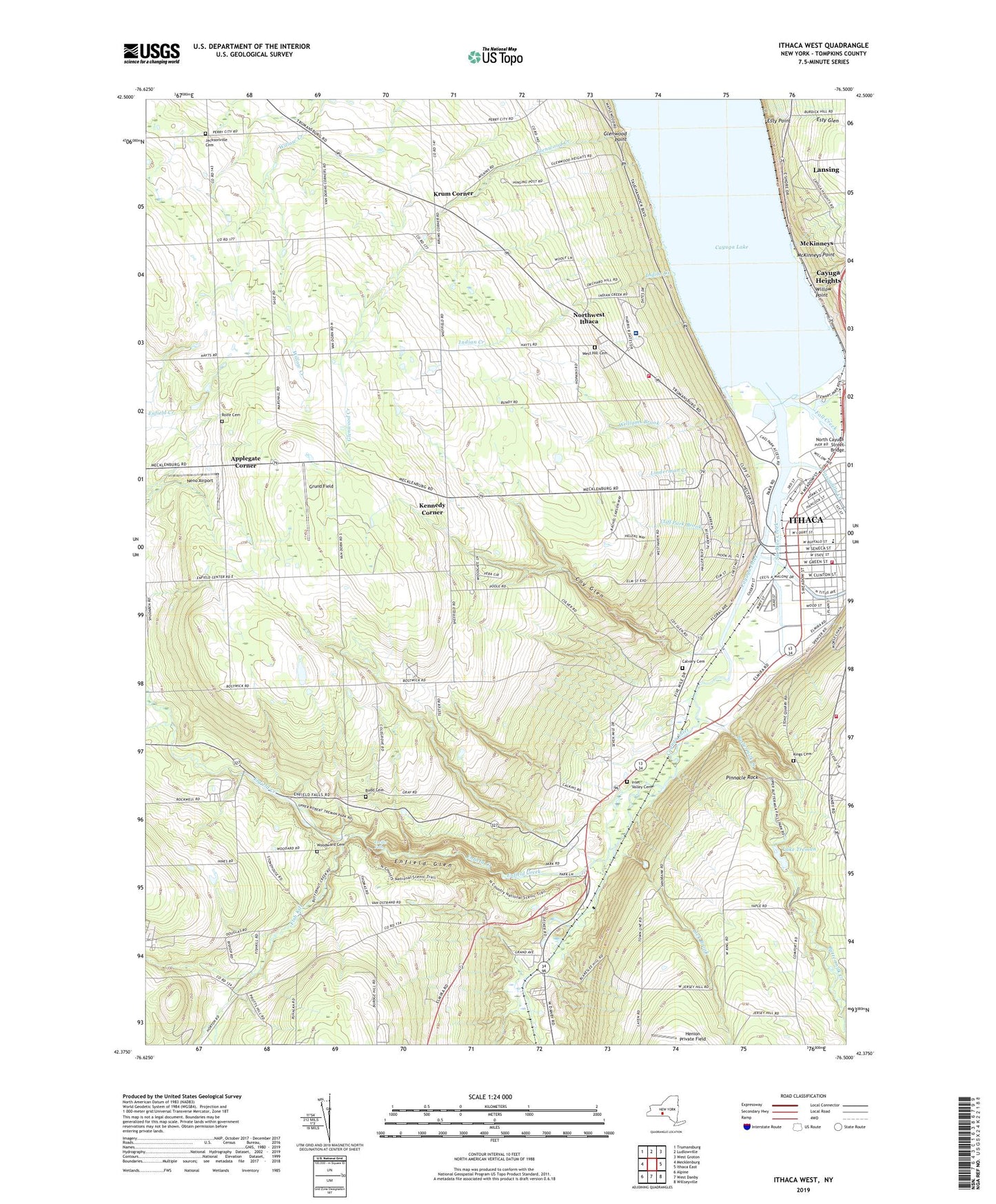
2023 topographic map quadrangle Ithaca West in the state of New York. Scale: 1:24000. Based on the newly updated USGS 7.5' US Topo map series, this map is in the following counties: Tompkins. The map contains contour data, water features, and other items you are used to seeing on USGS maps, but also has updated roads and other features. This is the next generation of topographic maps. Printed on high-quality waterproof paper with UV fade-resistant inks.
Quads adjacent to this one:
West: Mecklenburg
Northwest: Trumansburg
North: Ludlowville
Northeast: West Groton
East: Ithaca East
Southeast: Willseyville
South: West Danby
Southwest: Alpine
This map covers the same area as the classic USGS quad with code o42076d5.
Contains the following named places: Agape Bible Church, Alan Treman State Marine Park, Applegate Corner, Assembly of God Church, Baker Park, Bangs Ambulance, Baptized Church of Jesus, Bethlehem Church of Jesus Christ, Beverly J Martin Elementary School, Budd Cemetery, Buttermilk Creek, Buttermilk Falls State Park, Calvary Baptist Church, Calvary Cemetery, Calvary Full Gospel Church, Cascadilla Creek, Cayuga Heights Village WastewaterTreatment Plant, Cayuga Inlet, Cayuga Medical Center, Central School, Ceracche Center, Church of Christ, Church of the Immaculate Conception, City of Ithaca, Clare Bridge of Ithaca Assisted Living Center, Cliff Park Brook, College View Trailer Park, Conway Park, Coy Glen, Duboise Corner, Earlybird Farms, Enfield Creek, Enfield Glen, Esty Glen, Esty Point, Fall Creek, First Assembly of God Church, Fish Kill, Frank David Boynton Junior High School, Freeman Field, Front Light, Glenwood Creek, Glenwood Point, Glenwood School, Green Street House Assisted Living Center, Greentree Nursery, Grund Field, Hayt Corner, Henion Private Field, Henry Saint Johns School, Hillendale Golf Course, Houghton Poultry Farm, Immaculate Conception Parochial Roman Catholic School, Independent Order of Odd Fellows Home, Indian Creek, Inlet Valley Cemetery, Ithaca Area WastewaterTreatment Facility, Ithaca Boating Center, Ithaca Fire Department - Headquarters, Ithaca Fire Department South Hill Station 5, Ithaca Fire Department West Hill Station 6, Ithaca Plaza Shopping Center, Ithaca Yacht Club, Jacksonville Cemetery, Jim Butterfield Stadium, Kennedy Corner, Kings Cemetery, Krum Corner, Lake Treman, Lakes Car Drive-In, Lakeside Nursing Home, Lehman Alternative Community School, Lick Brook, Linderman Creek, Longview Assisted Living Center, Lucifer Falls, McKinneys, McKinneys Point, Meadowbrook Park, Neno Airport, Newman Municipal Golf Course, Noahs Boat Club, Northwest Ithaca Census Designated Place, Oldport Harbour, Pinecreek Campground, Pinnacle Rock, Quaker Settlement Church, Rear Light, Reformed Community Church, Renwick Brook, Robert H Treman State park, Rolfe Cemetery, Saint Catherine Greek Orthodox Church, Saint James African Methodist Episcopal Zion Church, Saint John Park, Sciencenter, Seventh Day Adventist Church, Six Mile Creek, Skyhook Lodge Airport, Southside Community Center, Sterling House of Ithaca Assisted Living Center, Stewart Park, The Reconstruction Home, Tompkins County Chapter American Red Cross, Tompkins County Home, Tompkins-Seneca County Vocational School, Town of Ithaca, Twin Glens, Van Dorn Corner, Washington Park, West Branch Cayuga Inlet, West Haven Farm, West Hill Cemetery, West Hill Community Church, Whipple Corner, Williams Brook, Willow Point, Woodward Cemetery