MyTopo
Medina New York US Topo Map
Couldn't load pickup availability
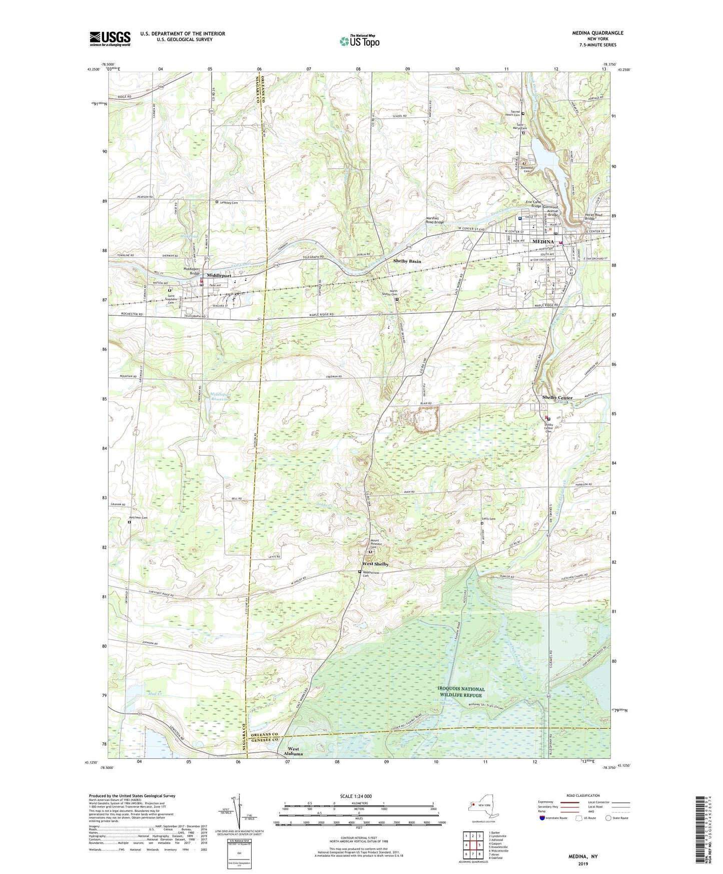
2023 topographic map quadrangle Medina in the state of New York. Scale: 1:24000. Based on the newly updated USGS 7.5' US Topo map series, this map is in the following counties: Orleans, Niagara, Genesee. The map contains contour data, water features, and other items you are used to seeing on USGS maps, but also has updated roads and other features. This is the next generation of topographic maps. Printed on high-quality waterproof paper with UV fade-resistant inks.
Quads adjacent to this one:
West: Gasport
Northwest: Barker
North: Lyndonville
Northeast: Ashwood
East: Knowlesville
Southeast: Oakfield
South: Akron
Southwest: Wolcottsville
This map covers the same area as the classic USGS quad with code o43078b4.
Contains the following named places: Apple Gate Adult Home, Applewood Mobile Home Estates, Boxwood Cemetery, Clifford H Wise Middle School, Cobb Building, Diana Theatre, Elpay Farms, Ensign Avenue Grade School, Erie Canal Bridge, First Baptist Church, First Methodist Church, First Presbyterian Church, Flyway Farm, Full Gospel Fellowship, George Farms, Glad Tiding Baptist Church, Glenwood Avenue Bridge, Glenwood Lake, Grace Baptist Church of Medina, Grant Landing Strip, Hird Farm, Holy Cross Church, Horan Road Bridge, Iroquois National Wildlife Refuge, K C Farms, Ketchem Cemetery, Kingdom Hall of Jehovah's Witnesses, Lakewood Village, Ledge Rock Farms, Lee-Whedon Memorial Library, Letts Cemetery, LeValley Cemetery, Marshall Road Bridge, Medina, Medina Fire Department, Medina Grade School, Medina High School, Medina Memorial Hospital, Medina Memorial Hospital Heliport, Medina Memorial Hospital Skilled Nursing Facility, Medina Post Office, Medina Village Hall, Medina Waste Water Treatment Plant, Middleport, Middleport Bridge, Middleport Fire Company Station 1, Middleport Free Library, Middleport Fundamental Baptist Church, Middleport Post Office, Middleport Reservoir, Middleport Wastewater Treatment Plant, Mill Pond, Mount Pleasant Cemetery, Neuter Fort, New Life Alliance Church, North Shelby Cemetery, Oak Orchard Elementary School, Oak Orchard Park, Oak Orchard Street School, Old Mill Mobile Home Park, Orleans-Niagara Boces School, Park Avenue School, Roberts Farms, Royalton - Hartland Middle School, Royalton-Hartland Central School, S A Ross Building, Sacred Heart Cemetery, Sacred Heart Roman Catholic Church, Saint John's Episcopal Church, Saint Marys Cemetery, Saint Mary's Roman Catholic Church, Saint Mary's School, Saint Peter's Evangelical Lutheran Church, Saint Stephens Cemetery, Saint Stephens Roman Catholic Church, School Number 1, School Number 12, School Number 13, School Number 14, School Number 15, School Number 16, School Number 2, School Number 3, School Number 6, School Number 8, Shelby Basin, Shelby Center, Shelby Center Cemetery, Shelby Volunteer Fire Company, Shelridge Country Club, Smith's Medina View Farms, South Main Street Park, Sunset Drive-In, Town of Shelby, Trinity Evangelical Lutheran Church, Veterans Memorial Baseball Park, Village of Medina, Village of Middleport, Weatherwax Cemetery, West Alabama, West Shelby, ZIP Codes: 14103, 14105