MyTopo
Sag Harbor New York US Topo Map
Couldn't load pickup availability
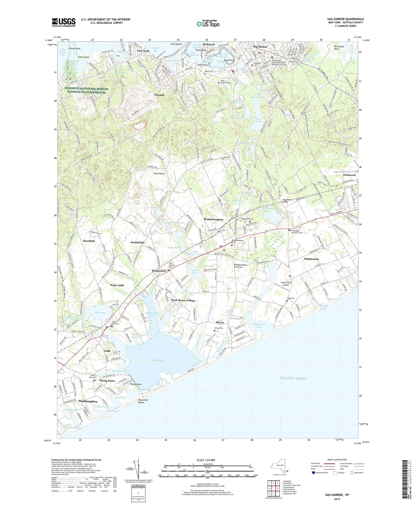
2019 topographic map quadrangle Sag Harbor in the state of New York. Scale: 1:24000. Based on the newly updated USGS 7.5' US Topo map series, this map is in the following counties: Suffolk. The map contains contour data, water features, and other items you are used to seeing on USGS maps, but also has updated roads and other features. This is the next generation of topographic maps. Printed on high-quality waterproof paper with UV fade-resistant inks.
Quads adjacent to this one:
West: Southampton
Northwest: Southold
North: Greenport
Northeast: Gardiners Island West
East: East Hampton
South: Sag Harbor OE S
Southwest: Shinnecock Inlet
Contains the following named places: Beebe Windmill, Black Pond, Bluff Point, Bridgehampton, Bridgehampton Cemetery, Bridgehampton Census Designated Place, Bridgehampton Golf Club, Bridgehampton Pit, Bridgehampton Post Office, Bridgehampton Race Circuit, Bridgehampton Station, Bridgehampton Volunteer Fire Department, Brush Neck, Burnett Creek, Calf Creek, Camps Pond, Channel Pond, Christ Episcopal Church, Clam Island, Cobb, Community Bible Church, Crooked Pond, Deerfield, Edgewood Cemetery, Elizabeth Alexandra Morton National Wildlife Refuge, Fairfield Pond, First Presbyterian Church, Flying Point, Flying Point Cemetery, Foster Farm Airport, Goldfish Pond, Haines Pond, Hampton Airport, Hamptons Drive-In, Hay Ground Cemetery, Hayground, Hayground Cove, John Jermain Memorial Library, Jule Pond, Kellis Pond, Ligonee Brook, Lily Pond, Little Long Pond, Little Poxabogue Pond, Little Round Pond, Long Beach, Long Point, Long Pond, Mashashimuet Park, Mecox, Mecox Bay, Mecox Cemetery, Mecox Life Saving Station, Mill Creek, Mill Pond, Morris Cove, Mud Creek, Noyac Cemetery, Noyac Golf And Country Club, Noyack, Noyack Census Designated Place, Noyack Creek, Noyack Radio Tower, Oakland Cemetery, Old Town Pond, Otter Pond, Paynes Creek, Peters Pond, Phillips Pond, Pierson High School, Pine Neck, Poxabogue County Park, Poxabogue Evergreen Cemetery, Poxabogue Golf Course, Poxabogue Pond, Rainbow Preschool, Rattlesnake Creek, Redwood, Rosemary Lodge, Round Pond, Sag Harbor, Sag Harbor Elementary School, Sag Harbor Fire Department Headquarters, Sag Harbor Fire Department Otter Hose Company 3, Sag Harbor Golf Course, Sag Harbor United Methodist Church, Sag Harbor Volunteer Ambulance, Sag Harbor Volunteer Ambulance Corps, Sag Harbor Volunteer Fire Department Murray Hill Hose Company 4, Sag Harbor Whaling Museum, Sagaponack, Sagaponack Historic District, Sagaponack Pond, Sagaponack Post Office, Sagg Cemetery, Sagg Road Bridge, Sagg Swamp Nature Preserve, Saint Andrews Cemetery, Saint Andrews Roman Catholic Church, Saint David African Methodist Episcopal Zion Cemetery, Saint David's African Methodist Episcopal Zion Church, Sams Creek, Sayre Pond, Scuttlehole, Seven Ponds, Shorts Pond, Slate Pond, Southampton Life Saving Station, Stella Maris Regional School, Swan Creek, Temple Adas Israel, The Big Narrows, The Little Narrows, Trout Pond, Union Chapel, Upper Sag Harbor Cove, Village of Sag Harbor, Village of Sagaponack, Wainscott Station, Water Mill, Water Mill Beach Club, Water Mill Cemetery, Water Mill Census Designated Place, Water Mill Post Office, Watermill Beach, WBAZ-FM (Southold), West Mecox Village, Wickapogue Pond, Wickapogue Road Historic District, WLNG-AM (Sag Harbor), WLNG-FM (Sag Harbor), ZIP Codes: 11932, 11962, 11963, 11976