MyTopo
Gardiners Island West New York US Topo Map
Couldn't load pickup availability
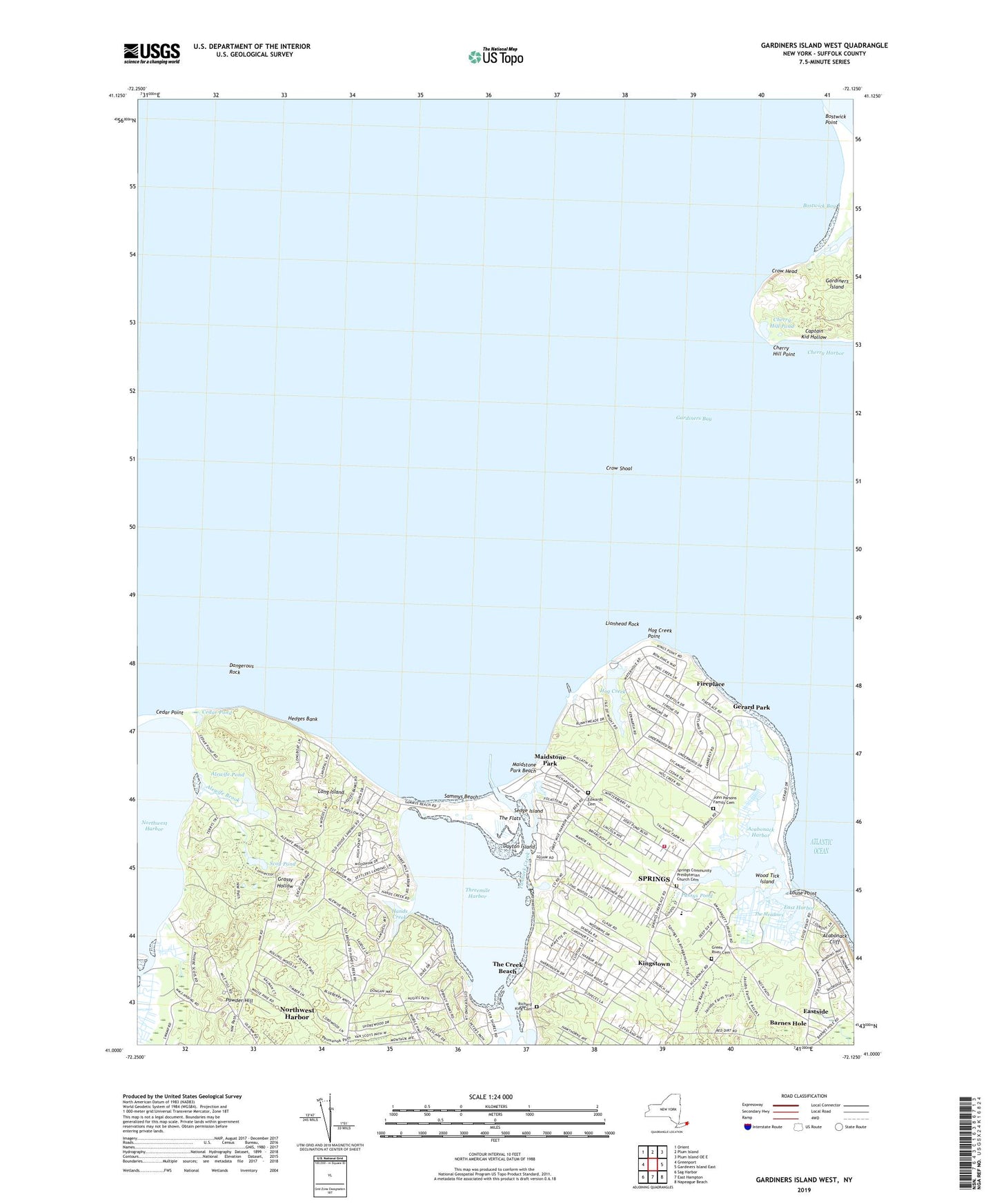
2023 topographic map quadrangle Gardiners Island West in the state of New York. Scale: 1:24000. Based on the newly updated USGS 7.5' US Topo map series, this map is in the following counties: Suffolk. The map contains contour data, water features, and other items you are used to seeing on USGS maps, but also has updated roads and other features. This is the next generation of topographic maps. Printed on high-quality waterproof paper with UV fade-resistant inks.
Quads adjacent to this one:
West: Greenport
Northwest: Orient
North: Plum Island
Northeast: Plum Island OE E
East: Gardiners Island East
Southeast: Napeague Beach
South: East Hampton
Southwest: Sag Harbor
This map covers the same area as the classic USGS quad with code o41072a2.
Contains the following named places: Acabonack Cliff, Acabonack Harbor, Alewife Brook, Alewife Brook Landing, Alewife Pond, Barcelona Bank, Barnes Landing, Blue Bay Girl Scout Camp, Bostwick Bay, Bostwick Point, Boys Harbor Summer Camp, C Gerard Park, Camp Saint Regis, Captain Kid Hollow, Captain Kid Monument, Cedar Point County Park, Cedar Pond, Cherry Hill Point, Cherry Hill Pond, Crow Head, Crow Shoal, Dangerous Rock, Dayton Island, East Hampton Commercial Dock, East Hampton Point Marina, East Harbor, Eastside, Edwards Cemetery, Edwards Island Sanctuary, Fireplace, Fireplace Lodge Girls Camp, Gardiners Bay, Gardiner's Marina, Gerard Park, Grace Estate, Grace Estate Preserve, Grassy Hollow, Green River Cemetery, Halsey's Marina, Hands Creek, Hands Creek Landing, Harbor Marina, Hedges Bank, Hog Creek, Hog Creek Point, John Parsons Family Cemetery, Kaplan Meadows Sanctuary, Kingstown, Lafarges Landing, Lionhead Rock, Louse Point, Maidstone Park, Maidstone Park Beach, Merrill Lake Sanctuary, Mill Hills Estates, Northwest Creek, Northwest Harbor, Northwest Harbor Census Designated Place, Northwest Landing, Northwest Woods, Our Lady of the Wayside Chapel, Powder Hill, Pussys Pond, Richard King Cemetery, Sammys Beach, Scoy Pond, Sedge Island, Shagwong Marina, Springs, Springs Census Designated Place, Springs Community Presbyterian Church, Springs Community Presbyterian Church Cemetery, Springs Fire Department, Sunset Cove Marina, The Creek Beach, The Flats, The Meadows, Three Mile Harbor Boat Yard, Threemile Harbor, Whispering Woods, Wood Tick Island, ZIP Code: 11937