MyTopo
Wake Forest North Carolina US Topo Map
Couldn't load pickup availability
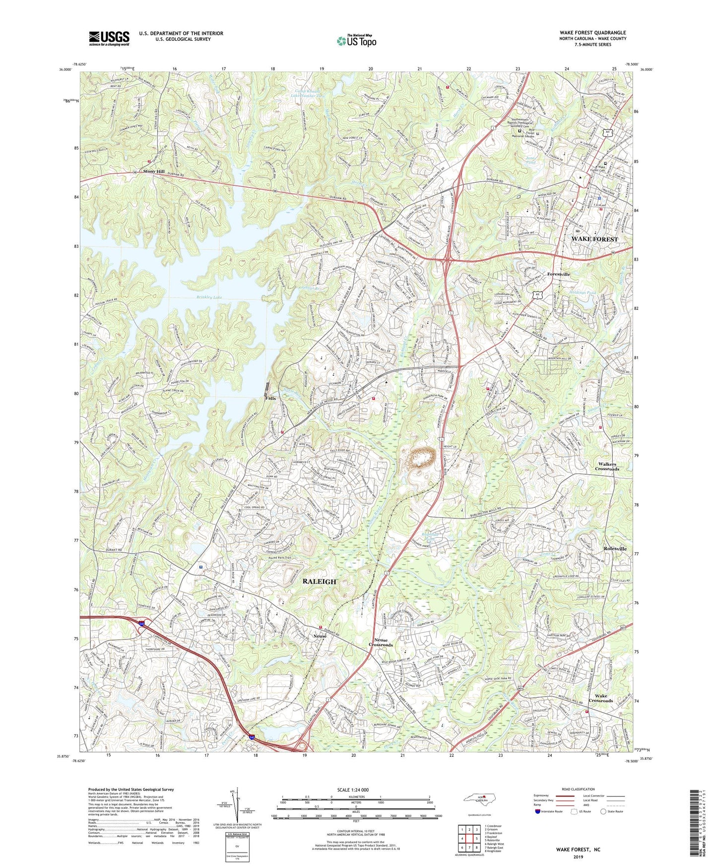
2022 topographic map quadrangle Wake Forest in the state of North Carolina. Scale: 1:24000. Based on the newly updated USGS 7.5' US Topo map series, this map is in the following counties: Wake. The map contains contour data, water features, and other items you are used to seeing on USGS maps, but also has updated roads and other features. This is the next generation of topographic maps. Printed on high-quality waterproof paper with UV fade-resistant inks.
Quads adjacent to this one:
West: Bayleaf
Northwest: Creedmoor
North: Grissom
Northeast: Franklinton
East: Rolesville
Southeast: Knightdale
South: Raleigh East
Southwest: Raleigh West
This map covers the same area as the classic USGS quad with code o35078h5.
Contains the following named places: Agape Word Fellowship Church, Brown Lake Dam, Camp Durant, Camp Durant Lake Number One Dam, Camp Durant Lake Number Two Dam, Camp Kanata Lake Number One Dam, Camp Kanata Lake Number Two, Camp Kanata Lake Number Two Dam, Cedar Creek, Durant Road Elementary School, Durant Road Middle School, Falls, Falls of the Neuse Dam, Forestville, Fuller Pond, Fuller Pond Dam, Greshams Lake Dam, Hatters Branch, Higher Ground Church, Holdings Pond, Holdings Pond Dam, Honeycutt Creek, Horse Creek, Jennys Branch, Jones Pond, Jones Pond Dam, Kingdom Hall of Jehovah's Witnesses, Lifepointe Christian Church, Lowery Creek, Marshalls Pond Dam Number One, Marshalls Pond Number One, Mount Pleasant Church, Mount Vernon Church, Mud Branch, Neuse, Neuse Baptist Church, Neuse Crossroads, New Fire Worship Center, New Life Camp, North Raleigh Church of Christ, North Raleigh United Methodist Church, North Raleigh United Methodist Preschool, North Ridge Elementary School, North Ridge Lower Dam, North Ridge Upper Dam, Northview Community Church, Olde Mount Vernon Church, Open Door Baptist Church, Perry Creek, Pierce Creek, Pine Forest Memorial Garden, Ragsdale Pond, Ragsdale Pond Dam, Raleigh Fire Department Station 22, Raleigh Fire Department Station 25, Raleigh Fire Department Station 28, Raleigh North Christian Center, Raleigh Quarry, Redeemed Christian Church of God, Richland Creek, Ridge Crest Church, Sanford Creek, Smith Creek, Southeastern Baptist Theological Seminary Cemetery, Southeastern Theological Seminary, Stony Hill, Stony Hill Church, Stony Hill Rural Fire Department Station 1, Thompsons Mill, Toms Creek, Town of Wake Forest, Township of Neuse, Wake County Emergency Medical Services Station 10, Wake Cross Roads Baptist Church, Wake Crossroads, Wake Forest, Wake Forest Cemetery, Wake Forest Elementary School, Wake Forest Fire Department Station 1, Wake Forest Fire Department Station 2, Wake Forest Fire Department Station 5, Wake Forest Police Department, Wake Forest Post Office, Wake Forest-Rolesville Middle School, Wake Forest-Rolesville Senior High School, Wake Med North Family Health and Women's Hospital, Wakefield Elementary School, Wakefield High School, Wakefield Middle School, Wakefield Pond Number One, Wakefield Pond Number One Dam, Wakefield Pond Number Two Dam, Walkers Crossroads, Water Fork, Wyatt, ZIP Codes: 27587, 27614