MyTopo
Beaufort North Carolina US Topo Map
Couldn't load pickup availability
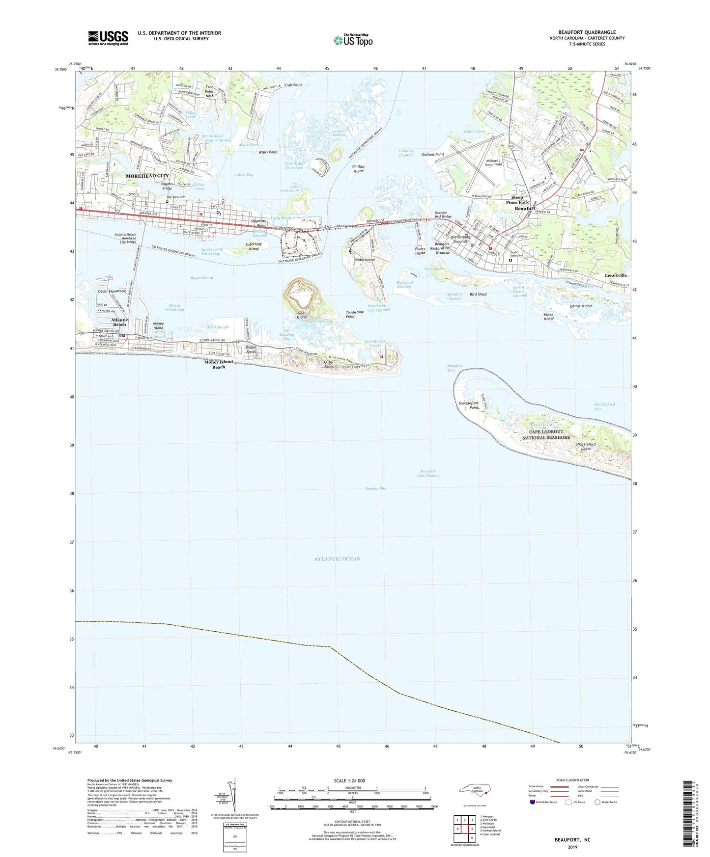
2022 topographic map quadrangle Beaufort in the state of North Carolina. Scale: 1:24000. Based on the newly updated USGS 7.5' US Topo map series, this map is in the following counties: Carteret. The map contains contour data, water features, and other items you are used to seeing on USGS maps, but also has updated roads and other features. This is the next generation of topographic maps. Printed on high-quality waterproof paper with UV fade-resistant inks.
Quads adjacent to this one:
West: Mansfield
Northwest: Newport
North: Core Creek
Northeast: Williston
East: Harkers Island
Southeast: Cape Lookout
This map covers the same area as the classic USGS quad with code o34076f6.
Contains the following named places: Allen Slough, Anchorage Marina, Apple Mobile Home Park, Atlantic Beach, Atlantic Beach - Morehead City Bridge, Atlantic Beach Fire Department Station 34, Atlantic Beach Police Department, Atlantic Beach Post Office, Atlantic Beach Town Hall, Ballow Mobile Home Park, Bay View Cemetery, Beaufort, Beaufort Biological Laboratory, Beaufort Channel, Beaufort Docks, Beaufort Elementary School, Beaufort Emergency Medical Services, Beaufort Fire Department, Beaufort High School, Beaufort Inlet, Beaufort Inlet Channel, Beaufort Meadows, Beaufort Middle School, Beaufort Police Department, Beaufort Post Office, Beaufort Restoration Grounds, Beaufort Town Hall, Bertram Mobile Home Park, Bird Shoal, Bridgeway Church, Bulkhead Channel, Calico Bay, Calico Creek, Calico Creek Marsh, Calvary Baptist Church, Carolina City, Carrot Island, Carrot Island Channel, Carteret County Criminal Court, Carteret County Detention Center, Carteret County Public Library, Carteret County Sheriff's Office, Cedar Hammock, Charles S Wallace High School, Coast Guard Station Fort Macon, Country Club East, Crab Point, Crab Point Bay, Crab Point Neck, Crab Point Thorofare, Dennis Bay, Dockside Marina, Duke University Marine Laboratory, First Baptist Church of Beaufort, Fishing Creek, Ford Dobbs, Fort Hampton, Fort Macon, Fort Macon Creek, Fort Macon State Park, Gable Creek, Gallant Point, Gallants Channel, Gibbs Creek, Goat Island, Grace Presbyterian Church, Grayden Paul Bridge, Harbor Channel, Harborview Health Care Center, Highland Park, Horse Island, Keeter Park, Kingdom Hall of Jehovahs Witnesses, Lenoxville, Maranatha Pentecostal Holiness Church, Michael J Smith Field, Money Island, Money Island Bay, Money Island Beach, Money Slough, Morehead City, Morehead City Channel, Morehead City Fire / EMS Station 1, Morehead City Fire and Emergency Medical Services Department Station 2, Morehead City Hall, Morehead City Police Chief, Morehead City Police Department, Morehead City State Port Terminal Airport, Morehead Elementary School, Morehead Gulf Docks, Morehead Plaza Center, Morhead City Middle School, Mount Zion Baptist Church, Mullet Pond, N C State Port Authority, New Hope Baptist Church, Newport Marshes, Newport River, North Carolina Maritime Museum, Oakwood Acres, Ocean View Cemetery, Oceana Pier, Oilles Creek, Old Burying Grounds, Phillips Island, Piggotts Bridge, Pivers Island, Portside Marina, Purvis Chapel African Methodist Episcopal Zion Church, Queen Street Missionary Baptist Church, Rachael Carson National Estuarine Sanctuary, Radio Island, Saint Egbert School, Saint Pauls Episcopal Church, Schooner Shores Group Home, Shackleford Point, Shell Landing, Shepards Point, Sportsmans Pier, Steep Pines Fork, Sugarloaf Island, Sunrise Point, Tar Landing Bay, Taylor Creek, The Beaufort Original Freewill Baptist Church, The Causeway, The Haystacks, Tombstone Point, Town Marsh, Town of Atlantic Beach, Town of Beaufort, Town of Morehead City, Triple S Marina Village, Turner Creek, United States Coast Guard Fire Department Station 4 Fort Macon, Wading Creek, WBMA-AM (Beaufort), Willis Creek, Willis Point, Yacht Basin, ZIP Code: 28557