MyTopo
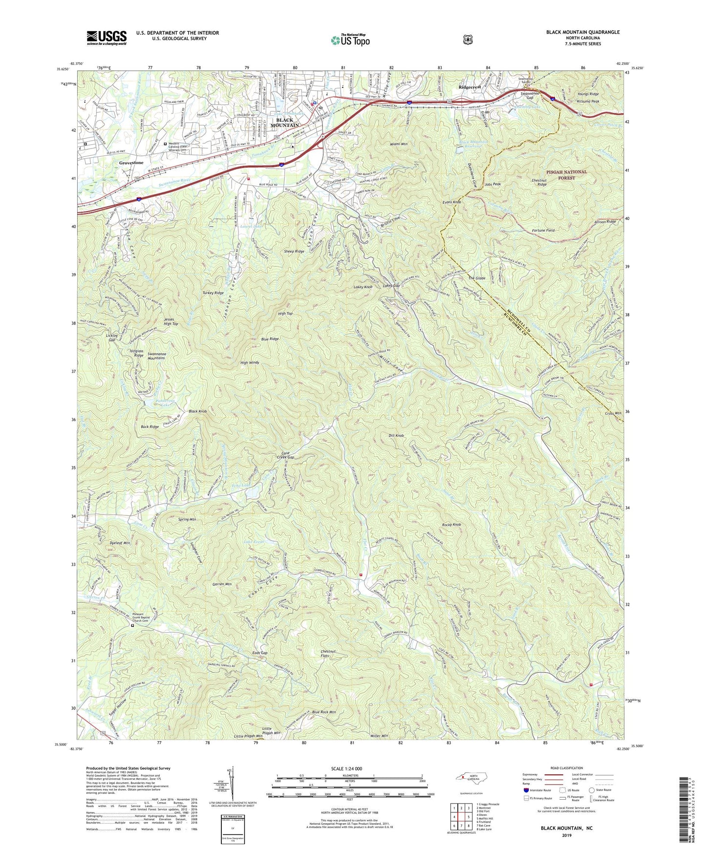
Black Mountain North Carolina US Topo Map
Couldn't load pickup availability
Also explore the Black Mountain Forest Service Topo of this same quad for updated USFS data
2022 topographic map quadrangle Black Mountain in the state of North Carolina. Scale: 1:24000. Based on the newly updated USGS 7.5' US Topo map series, this map is in the following counties: Buncombe, McDowell, Henderson. The map contains contour data, water features, and other items you are used to seeing on USGS maps, but also has updated roads and other features. This is the next generation of topographic maps. Printed on high-quality waterproof paper with UV fade-resistant inks.
Quads adjacent to this one:
West: Oteen
Northwest: Craggy Pinnacle
North: Montreat
Northeast: Old Fort
East: Moffitt Hill
Southeast: Lake Lure
South: Bat Cave
Southwest: Fruitland
This map covers the same area as the classic USGS quad with code o35082e3.
Contains the following named places: Allison Ridge, Assembly Lake, Black Knob, Black Mountain, Black Mountain Bi-Lo Plaza, Black Mountain Fire Department Station 4 - 2, Black Mountain Fire Department Station Four, Black Mountain Middle School, Black Mountain Police Department, Black Mountain Post Office, Black Mountain Primary School, Black Mountain Reservoir, Black Mountain Reservoir Dam, Black Mountain School, Blue Ridge Y M C A Camp, Blue Rock Mountain, Briar Branch, Brittin Cove, Broad River Church, Broad River Volunteer Fire and Rescue Department, Buck Ridge, Burgin Cove, Cabin Cove, Camp Branch, Camp Ridgecrest Dam, Cane Creek Gap, Carver Optional Elementary School, Chestnut Flats, Chestnut Ridge, Clear Branch, Clear Branch Church, Cross Mountain, Curteys Chapel, Dill Knob, Duck Branch, Dunsmore Cove, Dyeleaf Mountain, Eads Gap, Echo Lake, Echo Lake Dam, Elizabeth Chapel, Ellison Branch, Evans Knob, Fellowship Sanatorium, Flat Branch, Flat Creek, Fortune Field, Garren Creek Volunteer Fire Department, Garren Mountain, Glade Creek, Glen Cove, Grice Branch, Grovestone, High Top, High Windy, Isinglass Ridge, Jesses High Top, Jobs Peak, Johnson Cove, Julian F Keith Alcohol and Drug Abuse Treatment Center, Kitsuma Peak, Lake Evens, Lake Tomahawk, Lake Tomahawk Dam, Lakey Gap, Lakey Gap Chapel, Lakey Knob, Laughter Cove, Laurel Lake, Laurel Springs Church, Licklog Branch, Licklog Gap, Little Cove, Little Pisgah Camp Dam, Little Pisgah Mountain, Lynch Cove, McCoy Cove, Miami Mountain, Miller Cove, Mountain Orphanage, North Carolina State Test Farm, North Fork Swannanoa River, Pleasant Grove Baptist Church Cemetery, Pleasant Grove Church, Ponderosa Lake, Ponderosa Lake Dam, Reed Branch, Ridgecrest, Ridgecrest Post Office, Rock Creek, Rocky Knob, Rush Branch, Sand Branch, Sheep Ridge, Spring Mountain, Spring Mountain Branch, Spring Mountain Church, Stepp Branch, Sugar Hollow, Swannanoa Correctional Center for Women, Swannanoa Gap, Swannanoa Tunnel, Tabernacle Church, The Glade, Tom Creek, Tomahawk Branch, Town of Black Mountain, Township of Broad River, Turkey Ridge, Western Carolina State Veterans Cemetery, Western North Carolina Shopping Center, WFGW-AM (Black Mountain), Wilkey Church, Wolfpit Branch, WONO-AM (Black Mountain), Youngs Ridge, ZIP Code: 28711