MyTopo
Oteen North Carolina US Topo Map
Couldn't load pickup availability
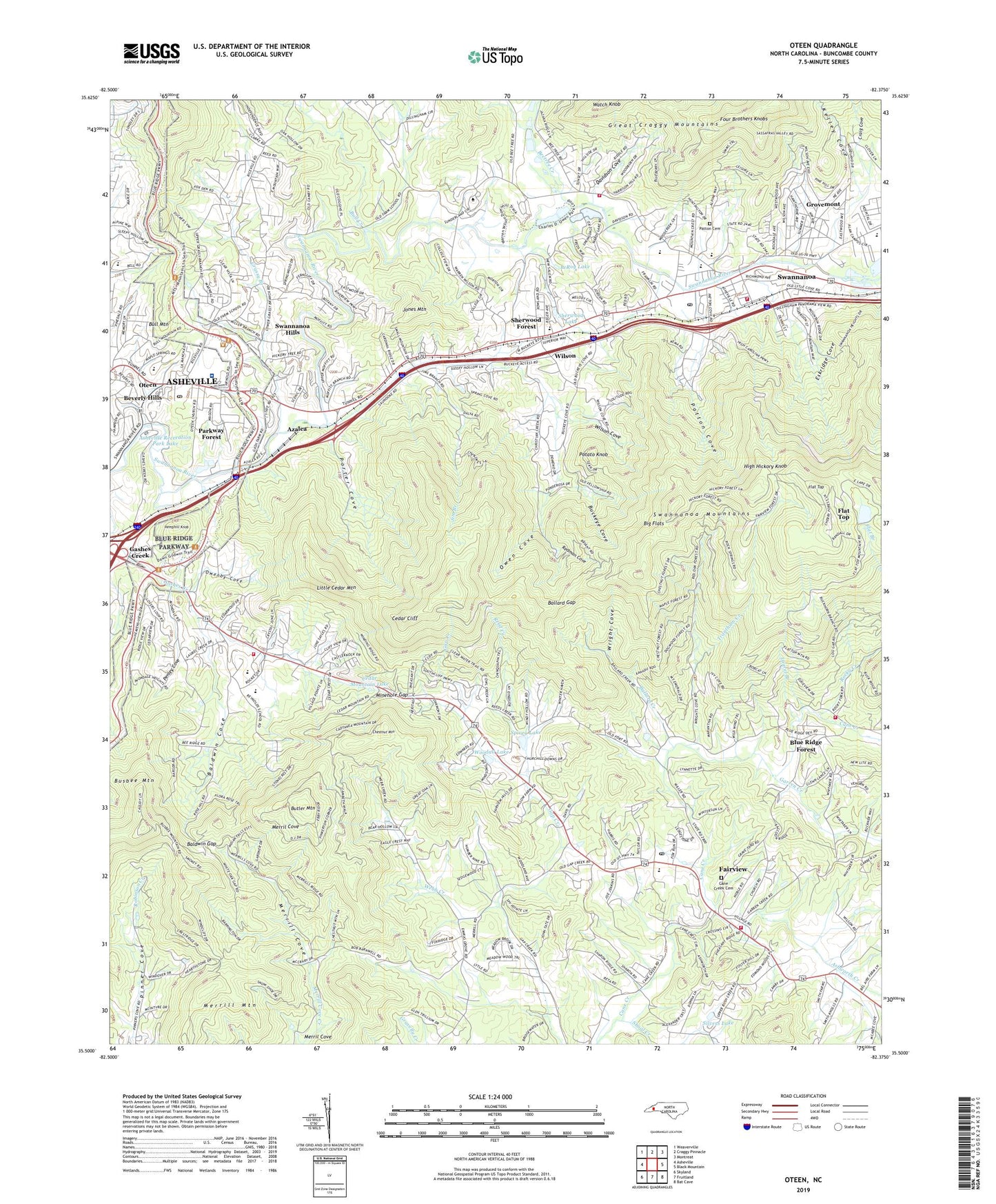
2022 topographic map quadrangle Oteen in the state of North Carolina. Scale: 1:24000. Based on the newly updated USGS 7.5' US Topo map series, this map is in the following counties: Buncombe. The map contains contour data, water features, and other items you are used to seeing on USGS maps, but also has updated roads and other features. This is the next generation of topographic maps. Printed on high-quality waterproof paper with UV fade-resistant inks.
Quads adjacent to this one:
West: Asheville
Northwest: Weaverville
North: Craggy Pinnacle
Northeast: Montreat
East: Black Mountain
Southeast: Bat Cave
South: Fruitland
Southwest: Skyland
This map covers the same area as the classic USGS quad with code o35082e4.
Contains the following named places: A C Reynolds High School, A C Reynolds Middle School, Asheville Recreation Park, Asheville Recreation Park Lake, Ashworth Creek, Azalea, Azalea Church, Baldwin Cove, Baldwin Gap, Ballard Creek, Ballard Gap, Beacon Reservoir, Beacon Reservoir Dam, Beetree Creek, Berea Church, Bethel Church, Big Flats, Blue Ridge Forest, Brush Creek Chapel, Buckeye Church, Buckeye Cove, Bull Creek, Bull Mountain, Busbee Mountain, Butler Mountain, Camp Blackfoot, Camp Swannanoa, Cane Creek Cemetery, Cane Creek Church, Cedar Cliff, Cedar Mountain Church, Cedar Mountain Lake, Charles C Bell School, Charles George Veterans Affairs Medical Center, Chestnut Mountain, Christian Creek Church, Craig Cove, Davidson Cove, Davis Lake, Emmas Grove Church, Eskridge Cove, Fairview, Fairview Census Designated Place, Fairview Post Office, Fairview School, Fairview Volunteer Fire Department Main Station, Fairview Volunteer Fire Department Substation, Fellowship of Southern Churchmen Camp, Flat Top, Flat Top Mountain Lake, Flattop Mountain Dam, Four Brothers Knobs, Garren Creek, Gashes Creek, Grassy Branch, Grovemont, Hemphill Knob, High Hickory Knob, Jim Branch, Jones Mountain, Kelley Cove, Lake Craig, Laurel Branch, Laurel Pines Church, LeRoy Lake, Little Cedar Mountain, Macedonia Church, Masters Branch, Merril Cove, Merrill Cove, Merrill Mountain, Minehole Gap, New Salem Church, Nolan Field, Oteen, Oteen Post Office, Owen Cove, Owen High School, Owenby Cove, Parkway Forest, Patton Cemetery, Patton Cove, Penley Cove, Pinner Cove, Porter Cove, Potato Knob, Redman Cove, Reed Creek, Reynolds Volunteer Fire Department / Buncombe County Emergency Medical Services Station 9, Rocky Creek, Rose Hill Church, Sharon Church, Sherwood Forest, Sherwood Lake, Shoal Creek, Silvers Lake, Spivey Lake, Swannann Middle School, Swannanoa, Swannanoa Census Designated Place, Swannanoa Church, Swannanoa Fire and Rescue Bee Tree Station, Swannanoa Fire and Rescue Department, Swannanoa Heights Church, Swannanoa Hills, Swannanoa Mountains, Swannanoa Post Office, Swannanoa School, Township of Fairview, Township of Swannanoa, Trantham Creek, Warren Wilson College, Webb Creek, Wilson, Wilson Cove, Woodall Lake, Wright Cove, ZIP Code: 28730