MyTopo
Clemmons North Carolina US Topo Map
Couldn't load pickup availability
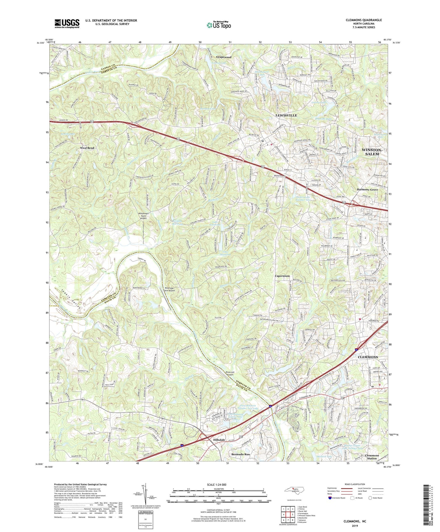
2022 topographic map quadrangle Clemmons in the state of North Carolina. Scale: 1:24000. Based on the newly updated USGS 7.5' US Topo map series, this map is in the following counties: Forsyth, Davie, Yadkin. The map contains contour data, water features, and other items you are used to seeing on USGS maps, but also has updated roads and other features. This is the next generation of topographic maps. Printed on high-quality waterproof paper with UV fade-resistant inks.
Quads adjacent to this one:
West: Farmington
Northwest: East Bend
North: Vienna
Northeast: Rural Hall
East: Winston-Salem West
Southeast: Welcome
South: Advance
Southwest: Mocksville
This map covers the same area as the classic USGS quad with code o36080a4.
Contains the following named places: All-American Rose Selections Garden, Arnold Lake, Arnold Lake Dam, Beauchamp Lake, Bermuda Run, Bermuda Run Golf Course, Blacks Creek, Blanket Creek, Boyers Church, Capernium, Capernium Church, Center Grove Church, Cinnamon Ridge, Clemmons, Clemmons Center, Clemmons Elementary School, Clemmons Fire Department Station 10, Clemmons Fire Department Station 14, Clemmons Post Office, Clemmons Village Shopping Center, Clemmons West, Concord Church, Conrad Lake, Conrad Lake Dam, Creekwood, Cutters Creek, Davie County Emergency Medical Services Station 2, Davie Gardens, Double Creek, Durham Lake, Durham Lake Dam, Eaglewood, Ellison Creek, Forbush School, Forest Hills Estates, Fred Bahnson Number One Dam, Fred Bahnson Number One Lake, Fred Bahnson Number Two Dam, Fred Bahnson Number Two Lake, Grapevine Church, Grapewood, Griffith Mill Pond, Halls Ferry site, Harmony Grove, Hauser Creek, Haynes Estate Dam Number One, Haynes Estate Dam Number Two, Haynes Estate Lake Number One, Hillsdale, Hillsdale Census Designated Place, Immanuel Church, Johnson Creek, Lake Desmond, Lake Desmond Dam, Lake Falmouth, Lake Falmouth Dam, Lasater Lake, Lasater Mill Pond, Lasater Mill Pond Dam, Lewisville, Lewisville Elementary School, Lewisville Post Office, Lewisville Shopping Center, Lewisville Trails, Lewisville Volunteer Fire Department, Loflin Lake, Loflin Lake Dam, Lowery Lake, Macedonia Moravian, Mallard Lake, Meadowbrook Estates, Middlebrook, Mission Church, New Hope Church, Oaks Ferry, Panther Creek, Parker Lake Dam Number Two, Parker Lake Number Two, Parkwood Lake, Professional Plaza, Reynolds Lake, Reynolds Lake Dam, Rivercliff Airport, Riverside Farm Airport, Robinhood Forest, Rollingreen, Shallowford Lakes, Shallowford Lakes Dam Number One, Shamrock Farm Dam, Sharon Church, Sheek Creek, Shiloh Church, Southwest Junior High School, Sunny Acres Shopping Center, Tanglewood Park, The Manor House, Town of Bermuda Run, Town of Lewisville, Township of Clemmonsville, Township of Farmington, Township of Lewisville, Union Church, Union Hill Church, Valley Oaks, Village of Clemmons, Warners Church, Waterford, West Bend, West Forsyth High School, Westerly Forest, Westwood Shopping Center, Whiteheart Farm Airport, Williams Chapel, Wood Lee, Yadkin Valley, Yadkin Valley Fundamental Baptist Church, ZIP Codes: 27012, 27023