MyTopo
Rural Hall North Carolina US Topo Map
Couldn't load pickup availability
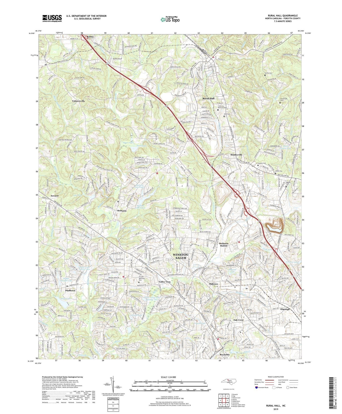
2022 topographic map quadrangle Rural Hall in the state of North Carolina. Scale: 1:24000. Based on the newly updated USGS 7.5' US Topo map series, this map is in the following counties: Forsyth. The map contains contour data, water features, and other items you are used to seeing on USGS maps, but also has updated roads and other features. This is the next generation of topographic maps. Printed on high-quality waterproof paper with UV fade-resistant inks.
Quads adjacent to this one:
West: Vienna
Northwest: Pinnacle
North: King
Northeast: Walnut Cove
East: Walkertown
Southeast: Winston-Salem East
South: Winston-Salem West
Southwest: Clemmons
This map covers the same area as the classic USGS quad with code o36080b3.
Contains the following named places: Alspaugh, Antioch Church, Babcock Lake, Babcock Lake Dam, Barkers Creek, BB&T Field, Beaver Dam Creek, Bethabara Church, Bethania, Bethania Golf Course, Bethania Post Office, Bethania Station, Bill Branch, Brookridge Stream, Carmichael Cemetery, Clayton Cemetery, Clinard Lake, Creek View, Creeson Lake, Creeson Lake Dam, Crestview Memorial Park, Crystal Lake, Dixie Classics Fairgrounds, Doug Young Dam Number Two, Doug Young Lake Number Two, Flint Cemetery, Forsyth County, Forsyth Memorial Park, Fowler Lake Number One, Fowler Lake Number One Dam, Fowler Lake Number Two, Fowler Lake Number Two Dam, Giant Shopping Center, Grandview Golf Lake, Grandview Golf Lake Dam, Grassy Creek, Griffin Cemetery, Hanes Lake, Hanes Lake Dam, Hickory Ridge Church, Hill Top Lake, Hill Top Lake Dam, Historic Bethabara Park, Hooks Baseball Stadium, Hunter Meadows, Jefferson Church, K and W Lake, K and W Lake Dam, Kentner Stadium, Lake Hills, Lake Hills Club Dam, Lawrence Joel Veterans Memorial Coliseum, Leak Fork, Linville Lake, Linville Lake Dam, Lower Temora Lake, Lower Temora Lake Dam, Lucy Branch, Macedonia Church, Mallard Lake Lower, Mallard Lake Lower Dam, Mallard Lake Upper, Mallard Lake Upper Dam, Mallard Lakes, Maple Springs Church, Marvin Church, Memorial Coliseum, Middle Gambill Dam, Middle Gambill Lake, Mill Creek Number 3, Minorcas Creek Par 3 Golf Course, Mizpah Church, Monarcas Creek, Mount Tabor High School, Nazareth Church, New Hope Church, North Point Mall, North Point Post Office, North Quarry, Northchase Shopping Center, Northwest Airstrip, Northwest Junior High School, Oak Crest, Oak Grove Church, Oak Grove School, Ogburn Branch, Ogburn Cemetery, Oil Mill Branch, Old Town, Old Town Elementary School, Old Town Shopping Center, Oldtown, Olivet Church, Paitts Lake, Parkers Creek, Petree Lake, Petree Lake Dam, Pfafftown, Pfafftown Post Office, Piatts Lake Dam, Pine Brook Golf and Country Club, Pine Brook Plaza, Pine Ridge Shopping Center, Piney Grove Church, Piney Grove School, Polo Park and Recreation Center, Reynolda, Reynolda Manor Shopping Center, Rural Hall, Rural Hall Elementary School, Rural Hall Fire and Rescue, Rural Hall Post Office, Saint James Church, Seward, Shattalon Lake, Shattalon Lake Dam, Speas Elementary School, Speas Lakes, Spry Soccer Stadium, Stanleyville, Stultz Cemetery, Summit School Airport, Temora Lake Estates, Tobaccoville, Tobaccoville Post Office, Tommys Fishing Lake Dam, Tower Gate, Town of Bethania, Town of Rural Hall, Township of Bethania, Township of Old Town, University Plaza Shopping Center, Valley View, Village of Tobaccoville, Village Shopping Center, WAAA-AM (Winston-Salem), Wake Forest Baseball Stadium, Wake Forest University, Wedgewood Airport, Whitaker Park, Winston - Salem Fire Department Old Town Fire Station 15, Winston - Salem Fire Department Station 14 Shattalon North, Winston - Salem Fire Department Station 20, Winston - Salem Fire Department Station 8 Wake Forest, ZIP Codes: 27045, 27106, 27109