MyTopo
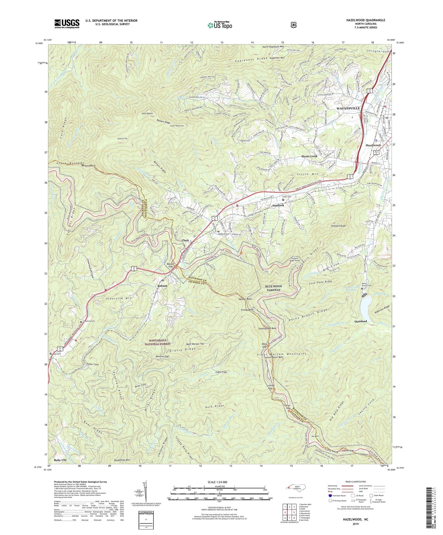
Hazelwood North Carolina US Topo Map
Couldn't load pickup availability
2019 topographic map quadrangle Hazelwood in the state of North Carolina. Scale: 1:24000. Based on the newly updated USGS 7.5' US Topo map series, this map is in the following counties: Haywood, Jackson. The map contains contour data, water features, and other items you are used to seeing on USGS maps, but also has updated roads and other features. This is the next generation of topographic maps. Printed on high-quality waterproof paper with UV fade-resistant inks.
Quads adjacent to this one:
West: Sylva North
Northwest: Bunches Bald
North: Dellwood
Northeast: Clyde
East: Waynesville
Southeast: Sam Knob
South: Tuckasegee
Southwest: Sylva South
Contains the following named places: Allen Creek, Allens Creek Elementary School, Balsam, Balsam - Willets - Ochre Hill Volunteer Fire Department Station 1, Balsam - Willets - Ochre Hill Volunteer Fire Department Station 2, Balsam Gap, Balsam Post Office, Balsam Ridge, Bearpen Branch, Beef Market Top, Beetree Gap, Big Cove, Boar Ridge, Brier Cove, Brier Ridge, Browning Branch, Cabin Creek, Cabin Flats, Camp Branch, Carson Branch, Cherry Cove, Chewing Gum Cove, Clark, Cove Field Branch, Cove Field Ridge, Crawford Cemetery, Cut-Off Ridge, Dark Ridge, Dark Ridge Creek, Deep Gap, Doubletop Creek, Doubletop Mountain, Drift Branch, Eaglenest, Eaglenest Creek, Eaglenest Mountain, Eaglenest Ridge, East Fork Campbell Creek, Fairview Church, Farmer Branch, Fisher Cove, Flat Gap, Flint Spring Creek, Fowler Balsam Mountain, Foxtown Ridge, Grassy Bald, Grassy Ridge, Grassy Ridge Mine, Haywood County Emergency Medical Services - Medic 1 and Medic 5, Haywood County Sheriff's Office, Hazelwood, Hazelwood Post Office, Hazelwood Shopping Center, Hyatt Creek, Hyatt Creek Freewill Baptist Church, Jones Creek, Judaculla Mountain, Laurel Patch Bald, Licklog Creek, Licklog Gap, Little Branch, Little Mountain, Locust Gap, Lone Bald, Long Branch, Long Swag, Love Cemetery, Micadale Church, Mingus Ridge, Morrison Fish Hatchery, Mount Lyn Lowry, Mount Pleasant Church, Nolen Creek, Old Bald, Old Bald Creek, Old Bald Ridge, Oldfield Top, Oxear Cove, Pinnacle Knob, Pinnacle Ridge, Pinnacle Ridge Tunnel, Pleasant Balsam Baptist Church, Plott Balsam, Plott Cemetery, Plott Creek, Queen Camp Creek, Quinland, Redbank Branch, Redbank Cemetery, Rocky Branch, Rocky Branch Baptist Church Cemetery, Rocky Branch Church, Rocky Branch Ridge, Ruby City, Saunook, Saunook Volunteer Fire Department, South Fork Sugarloaf Creek, Spruce Ridge, Steestachee Bald, Steestachee Branch, Township of Scott Creek, Township of Waynesville, Waynesville Fire Department Station 2, Waynesville Reservoir, Waynesville Water Supply Dam, Wesner Bald, West Fork Campbell Creek, Winchester Creek, Woodfin Creek, Woodfin Falls, ZIP Code: 28707