MyTopo
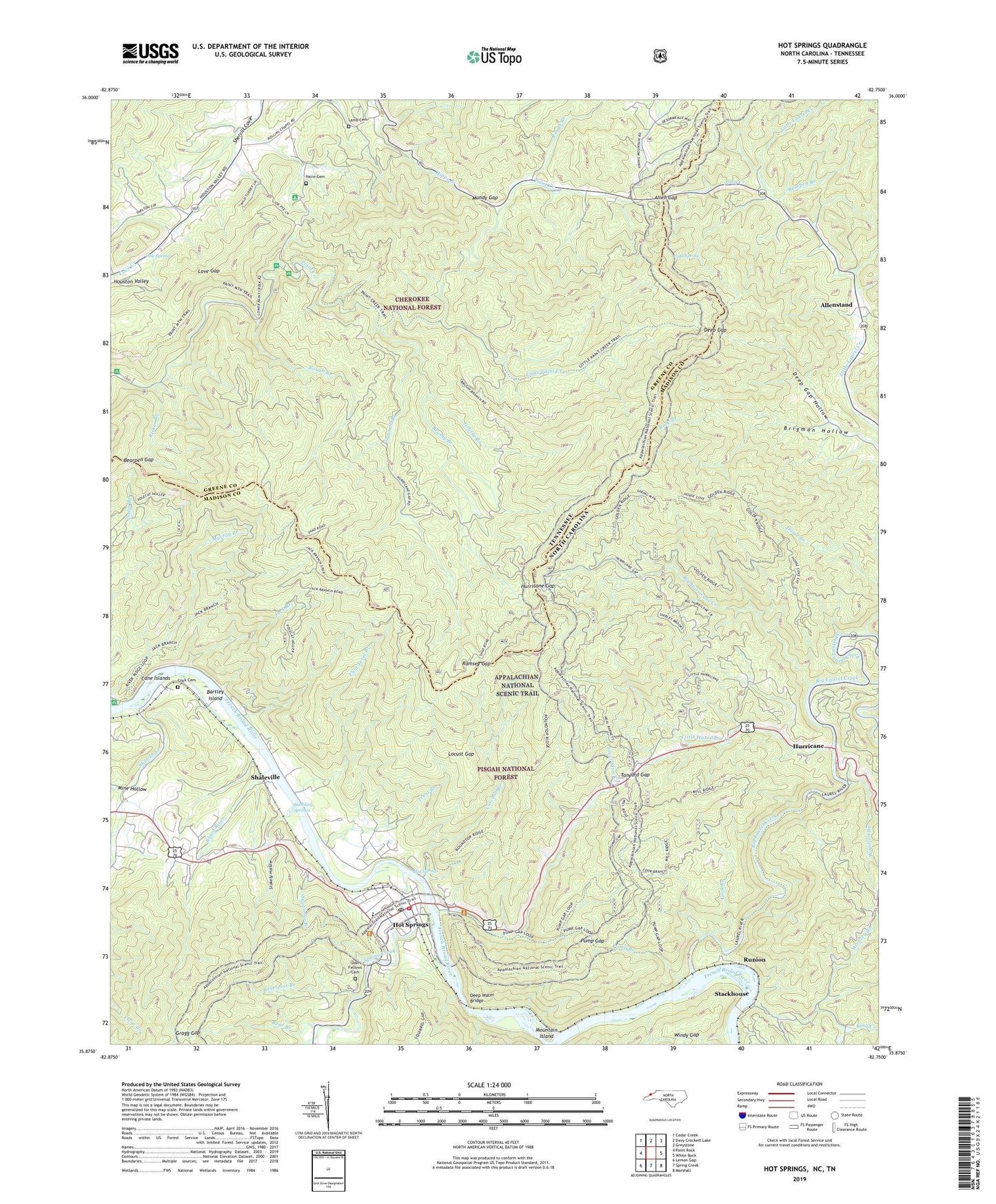
Hot Springs North Carolina US Topo Map
Couldn't load pickup availability
Also explore the Hot Springs Forest Service Topo of this same quad for updated USFS data
2022 topographic map quadrangle Hot Springs in the states of North Carolina, Tennessee. Scale: 1:24000. Based on the newly updated USGS 7.5' US Topo map series, this map is in the following counties: Madison, Greene. The map contains contour data, water features, and other items you are used to seeing on USGS maps, but also has updated roads and other features. This is the next generation of topographic maps. Printed on high-quality waterproof paper with UV fade-resistant inks.
Quads adjacent to this one:
West: Paint Rock
Northwest: Cedar Creek
North: Davy Crockett Lake
Northeast: Greystone
East: White Rock
Southeast: Marshall
South: Spring Creek
Southwest: Lemon Gap
Contains the following named places: Allen Creek, Allen Gap, Allenstand, Andrew Johnson Wildlife Management Area, Bald Mountains, Bartley Island, Bear Branch, Bearpen Branch, Bearpen Gap, Bellcow Mountain, Big Hurricane Creek, Big Laurel Creek, Blood River, Brushy Branch, Brushy Mountain, Bubbling Springs, Buzzard Roost Ridge, Cane Islands, Cascade Branch, CCC Camp Number F 7, Church of God, Click Cemetery, Cold Spring, Cold Spring Branch, Cook Branch, Courtland Place, Deep Gap, Deep Gap Hollow, Deep Water Bridge, Deer Park Mountain, Dudley Falls Picnic Area, Fairview Church, Flint Level Branch, French Broad Ranger Station, Golden Ridge, Gragg Gap, Grassy Branch, Grassy Ridge, Haire Cemetery, High Ridge, Highrock Camp, Horse Branch, Hot Springs, Hot Springs Elementary School, Hot Springs Fire Department, Hot Springs Post Office, Houston Valley, Hurricane, Hurricane Chapel, Hurricane Gap, Jack Branch, King Creek, Lamb Cemetery, Little Bottom Branch, Little Hurricane Creek, Little Knob, Little Paint Creek, Little Paint Creek Trail, Locust Gap, Love Gap, Love Road Picnic Area, Lovers Leap Ridge, Madison County Ambulance Service, Meadow Ridge, Mill Ridge, Mill Ridge Church, Mine Hollow, Moses Turn Picnic Area, Mountain Island, Mountain View School, Mundy Gap, Murray Branch, Murray Branch Picnic Area, Odd Fellows Cemetery, Overlook Picnic Area, Paint Creek Campground, Paint Creek Recreation Area, Paint Creek Trail, Pine Spring, Pine Spring Church, Piney Mountain, Pounding Mill Branch, Pump Branch, Pump Gap, Raccoon Branch, Ramsey Gap, Reservoir Branch, Rich Mountain, Rich Mountain Lookout, Rich-Laurel Wildlife Area, Ricker Branch, Ricker Mountain, Rock Branch, Rollins Chapel Church, Rollins Chapel School, Rough Branch, Roundtop Ridge, Runion, Sawmill Branch, Scraggy Ridge, Shaleville, Shelton Laurel Creek, Shut-In Creek, Silver Mine Creek, Spring Creek, Spring Mountain, Spring Mountain Trail Shelter, Stackhouse, Stokely Hollow, Sugartree Branch, Tanyard Gap, Town of Hot Springs, Township 6-Hot Springs, Trent Branch, Wadders Picnic Area, Walnut Gap, Walnut Knob, Windy Gap, Woodson Branch, Woolsey Branch