MyTopo
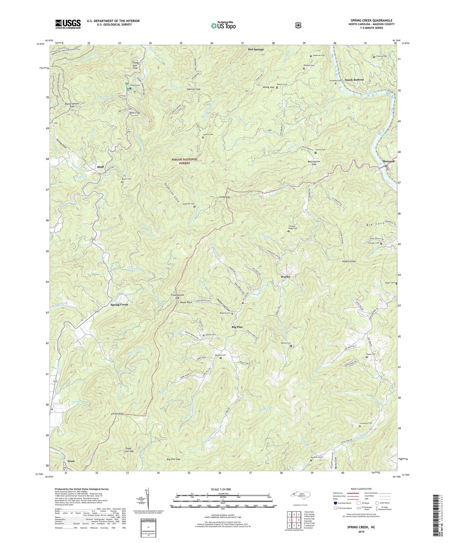
Spring Creek North Carolina US Topo Map
Couldn't load pickup availability
Also explore the Spring Creek Forest Service Topo of this same quad for updated USFS data
2022 topographic map quadrangle Spring Creek in the state of North Carolina. Scale: 1:24000. Based on the newly updated USGS 7.5' US Topo map series, this map is in the following counties: Madison. The map contains contour data, water features, and other items you are used to seeing on USGS maps, but also has updated roads and other features. This is the next generation of topographic maps. Printed on high-quality waterproof paper with UV fade-resistant inks.
Quads adjacent to this one:
West: Lemon Gap
Northwest: Paint Rock
North: Hot Springs
Northeast: White Rock
East: Marshall
Southeast: Leicester
South: Sandymush
Southwest: Fines Creek
This map covers the same area as the classic USGS quad with code o35082g7.
Contains the following named places: Anderson Cemetery, Anderson Cove, Back Branch, Baker Branch, Balm Grove Church, Baltimore Branch, Barnard, Barnard's Station Post Office, Barns Cove, Bearwallow Gap, Beck Branch, Bee Branch, Big Pine, Big Pine Cemetery, Big Pine Creek, Big Pine Gap, Big Pine Volunteer Fire Department, Bluff, Brooks Cemetery, Brown Cemetery, Brush Creek, Buckner Cemetery, Caldwell Branch, Canebrake Ridge, Cedar Knob, Charley Branch, Charlotte Branch, Coley Gap, Coonpatch Branch, Crooked Ridge Cemetery, Davis Branch, Divide Mountain, Dockery Cemetery, Doe Branch, Doe Branch School, Dry Pond Ridge, Duckett Lookout Tower, Edging Rock, Ellison Gap, Fall Branch, Farmer Mountain, Fork Mountain, Fortner Cemetery, Foxtown Mountain, Fradys Rough, Freeman Cemetery, Friezeland Creek, Gap-of-the-Mountain Church, Gentry Branch, Gentry Cemetery, Georgia Branch, Gladden Ridge, Goforth Cemetery, Granger Branch, Granger Mountain, Grassland Mountain, Grassland Ridge, Greasy Branch, Hagen Cemetery, Hap Mountain, Hickory Spur, High Poplar Ridge, High Shoal Branch, Highland Church, Hogskin Branch, Hollow Log Cove, Horse Knob, Hot Springs Mountain, House Rock, Indian Camp Branch, Lamb Knob, Leadmine Ridge, Levi Branch, Liberty Church, Little Mountain, Long Mountain, Long Mountain Branch, Lower Big Pine, Lower Big Pine School, Lunceford Cemetery, Massey Cemetery, Meadow Fork, Mountain Island Branch, North Fork Big Pine Creek, North Fork Church, Old Trail Ridge, Panther Branch, Payne Cemetery, Paynes Chapel, Peace Branch, Piney Mountain, Polecat Ridge, Primitive Church, Puncheon Camp Branch, Raccoon Branch, Rector Branch, Rector Butt, Rich Knob, Roberts Cemetery, Rocky Bluff Recreation Site, Rocky Branch, Rough Branch, Sandy Bottom, Sawmill Branch, Shoal Hill Church, Slaty Knob, Snakeden Ridge, South Fork Big Pine Creek, Spring Creek, Spring Creek Mountain, Spring Creek School, Spring Creek Volunteer Fire Department, Squirrel Branch, Squirrel Gap, Stafford Gap, Stafford Knob, Starret Knob, Steve Branch, Stony Spur, Stony Spur Cliff, Sugar Cove Gap, Sugarcamp Branch, Taylor Hollow Gap, Thomas Cemetery, Township 5-Walnut, Trail Ridge, Treadway Cemetery, Troublesome Gap, Trust, Turkey Cove, Turkey Mountain, Upper Big Pine School, Upper Little Pine School, Vann Cliff, Whiterock Branch, Wildcat Branch, Windy Gap, Wooleyshot Branch, Worley, Worley Mill Ridge, Zion Church