MyTopo
Mountain Island Lake North Carolina US Topo Map
Couldn't load pickup availability
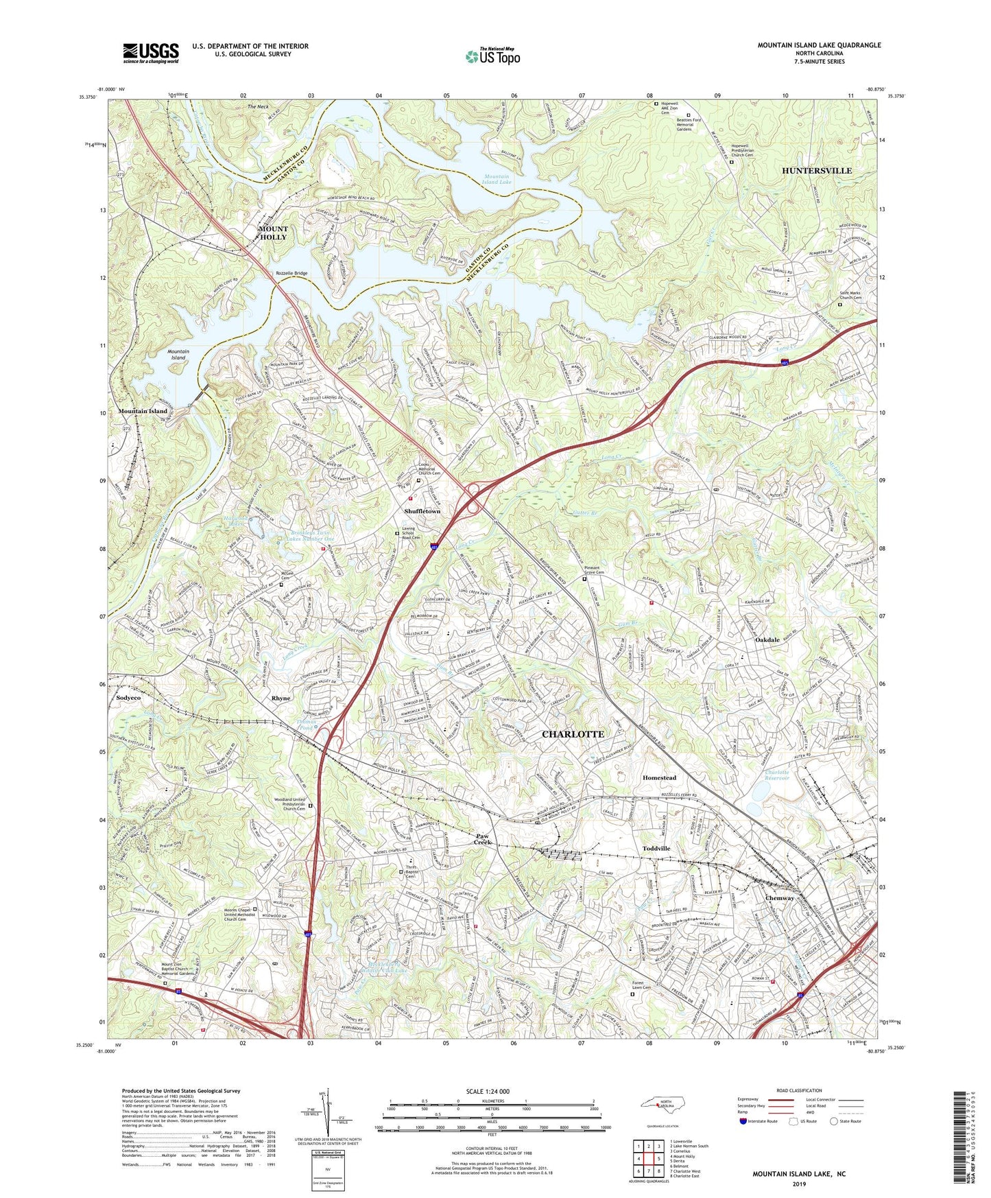
2023 topographic map quadrangle Mountain Island Lake in the state of North Carolina. Scale: 1:24000. Based on the newly updated USGS 7.5' US Topo map series, this map is in the following counties: Mecklenburg, Gaston. The map contains contour data, water features, and other items you are used to seeing on USGS maps, but also has updated roads and other features. This is the next generation of topographic maps. Printed on high-quality waterproof paper with UV fade-resistant inks.
Quads adjacent to this one:
West: Mount Holly
Northwest: Lowesville
North: Lake Norman South
Northeast: Cornelius
East: Derita
Southeast: Charlotte East
South: Charlotte West
Southwest: Belmont
This map covers the same area as the classic USGS quad with code o35080c8.
Contains the following named places: Allenbrook Elementary School, American Legion Golf Course, Arlington, Beatties Ford Memorial Gardens, Bethel Church, Brinkleys Twin Lakes, Brinkleys Twin Lakes Number One, Brinkleys Twin Lakes Number One Dam, Brookfield, Buzzard Rock Overlook, Charlotte Fire Department Station 13, Charlotte Fire Department Station 21, Charlotte Fire Department Station 25, Charlotte Fire Department Station 33, Charlotte Passport Office Post Office, Charlotte Reservoir, Charlotte Water Works, Chateau Woods, Chemway, Cooks Community Fire and Rescue, Cooks Memorial Church, Cooks Memorial Church Cemetery, Coulwood, Coulwood Hills, Coulwood Middle School, Crescent Pond, Deerwood, Duke Power Village, Dunham Memorial Baptist Church, Emmanuel Church, Fellowship Church, Forest Lawn Cemetery, Forest Pawtuckett, Forest Pawtuckett Shopping Center, Forest Rawtucket, Gar Creek, Gum Branch, Gutter Branch, Harwood Lake Dam, Harwood Lakes, Hillcrest Church, Homestead, Homestead United Methodist Church, Hope Farm, Hopewell AME Zion Cemetery, Hopewell AME Zion Church, Hopewell Church, Hopewell Presbyterian Church Cemetery, Horse Shoe, Hoskins, Hoskins School, Kellyville, Lake Kathleen, Lakeview School, Lawing School Road Cemetery, Lewis, Little Rock Road District Park, Long Creek Elementary School, Love Chapel, Martindale, McDowell Creek, McGee Cemetery, McIntyre Creek, Mecklenberg Wildlife Club Lake, Mecklenburg Wildlife Club Lake Dam, Memorial Church, Moores Chapel, Moores Chapel United Methodist Church Cemetery, Mount Zion Baptist Church Memorial Gardens, Mount Zion Church, Mountain Island, Mountain Island Elementary School, Mountain Island Lake, Mountain Island Reservoir Dam, Oakdale, Oakdale Elementary School, Oakdale Forest, Oakdale Post Office, Paw Creek, Paw Creek Christian Academy, Paw Creek Elementary School, Paw Creek Post Office, Pawtuckett Elementary School, Pawtuckett Golf Course, Pawtuckett Village Shopping Center, Pine Island, Pine Island Country Club, Pinewood School, Pinoca, Pleasant Grove Cemetery, Public Library of Charlotte and Mecklenburg County - Coulwood Branch, Rhyne, Ridgeview Church, Riverbend Church, Rozzelle Bridge, Saint Johns Chapel Primitive Baptist Church, Saint Josephs Church, Saint Marks Church, Saint Marks Church Cemetery, Shady Brook Church, Shuffletown, Sodyeco, Sunset Hills Golf Club, Sunset Road Church, Thomas Pond, Thomasboro, Thomasboro Academy, Thrift, Thrift Baptist Cemetery, Thrift Baptist Church, Thrift Road Church, Toddville, Town Park, Township 11-Long Creek, Township 12-Paw Creek, Tuskasaga, Twins Estates, WAME-AM (Charlotte), WAYS-AM (Charlotte), West Mecklenburg Volunteer Fire and Rescue Department, West Pointe Business Park, Westbourne, Westchester, Westside Baptist Church, Westwood Forest, White Oak Park, Wildwood, Woodford Green, Woodland Presbyterian Church, Woodland United Presbyterian Church Cemetery, Woodlea, WROQ-FM (Charlotte), WSOC-AM (Charlotte), ZIP Codes: 28214, 28216