MyTopo
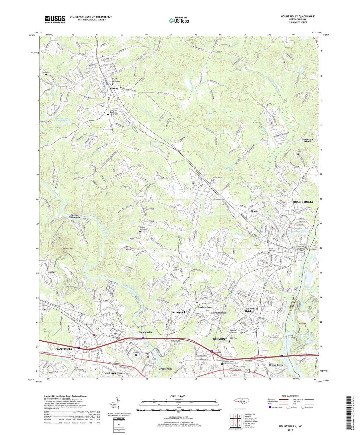
Mount Holly North Carolina US Topo Map
Couldn't load pickup availability
2022 topographic map quadrangle Mount Holly in the state of North Carolina. Scale: 1:24000. Based on the newly updated USGS 7.5' US Topo map series, this map is in the following counties: Gaston, Mecklenburg. The map contains contour data, water features, and other items you are used to seeing on USGS maps, but also has updated roads and other features. This is the next generation of topographic maps. Printed on high-quality waterproof paper with UV fade-resistant inks.
Quads adjacent to this one:
West: Gastonia North
Northwest: Lincolnton East
North: Lowesville
Northeast: Lake Norman South
East: Mountain Island Lake
Southeast: Charlotte West
South: Belmont
Southwest: Gastonia South
This map covers the same area as the classic USGS quad with code o35081c1.
Contains the following named places: Abbey Plaza, Aldersgate Church, Aviary Gardens, Beech Brook, Belmont Abbey Cemetery, Belmont Abbey College, Belmont Drive-In, Belmont Junction, Berea Church, Berea Church Cemetery, Bethel Church, Brown Town, Caldwell, Carolinas Rehabilitation Center - Mount Holly, Catawba Heights, Catawba Heights School, Cathey, Christs Lutheran Church Cemetery, City of Lowell, City of Mount Holly, Collegetown Shopping Center, Community Volunteer Fire Department, Craig Heights, Dutchmans Creek, East Gaston Senior High School, East Gaston Volunteer Fire Department Station 30, East Lincoln Fire Department, Eastwood Village, Ebenezer Church Cemetery, Edgewood Cemetery, Faith Church, Fites Creek, Goshen Grove, Green Meadows Country Club, Hickory Grove Cemetery, Hickory Grove Church, Hillcrest Cemetery, Holbrook High School, Humphrey School, Hutchinson, Kiser School, Little Long Creek, Long Creek, Lowell, Lowell Elementary School, Lowell Post Office, Lowell Volunteer Fire Department, Lucia - Riverbend Volunteer Fire Department, Martin Pond Number Two, Martin Pond Number Two Dam, Mauney Cemetery, McAdenville, McAdenville Elementary School, McAdenville Junction, McAdenville Lake, McAdenville Lake Dam, McAdenville Post Office, McAdenville Volunteer Fire Department, Morningside Cemetery, Mount Holly, Mount Holly Cemetery, Mount Holly Fire and Rescue Station 2, Mount Holly Fire and Rescue Station 34, Mount Holly Police Department, Mount Holly Post Office, Murphy Heights, New Providence Church, Nims, North Belmont, North Belmont Elementary School, Oakland Church, O'Conner Grove AME Zion Church Cemetery, O'Conners Grove Church, Pineview Cemetery, Queen of the Apostles Church, R E Rankin Lake, R E Rankin Lake Dam, Rankin Elementary School, Ridgeview Church, Rowland Lake Dam Number One, Rowland Lake Number One, Sharon Church, Sodyeco Lagoon, Sodyeco Lagoon Dam, South Stanley Creek, Spencer Mountain, Springfield Memorial Church, Springfield Memorial Church Cemetery, Springfield School, Springwood, Stanley, Stanley Civil Defense Rescue Squad, Stanley Creek, Stanley Junior High School, Stanley Park, Stanley Police Department, Stanley Post Office, Stanley Volunteer Fire Department, Stowe Memorial Chapel, Taylor Heights, Taylors Creek, Town of McAdenville, Town of Spencer Mountain, Town of Stanley, Township of Riverbend, True Light Church, WBCY-FM (Charlotte), WBTV-TV (Charlotte), WCGC-AM (Belmont), Wesleyan Church, West Cramerton, Woodland, Woodlawn Church, ZIP Codes: 28098, 28101, 28120