MyTopo
Belmont North Carolina US Topo Map
Couldn't load pickup availability
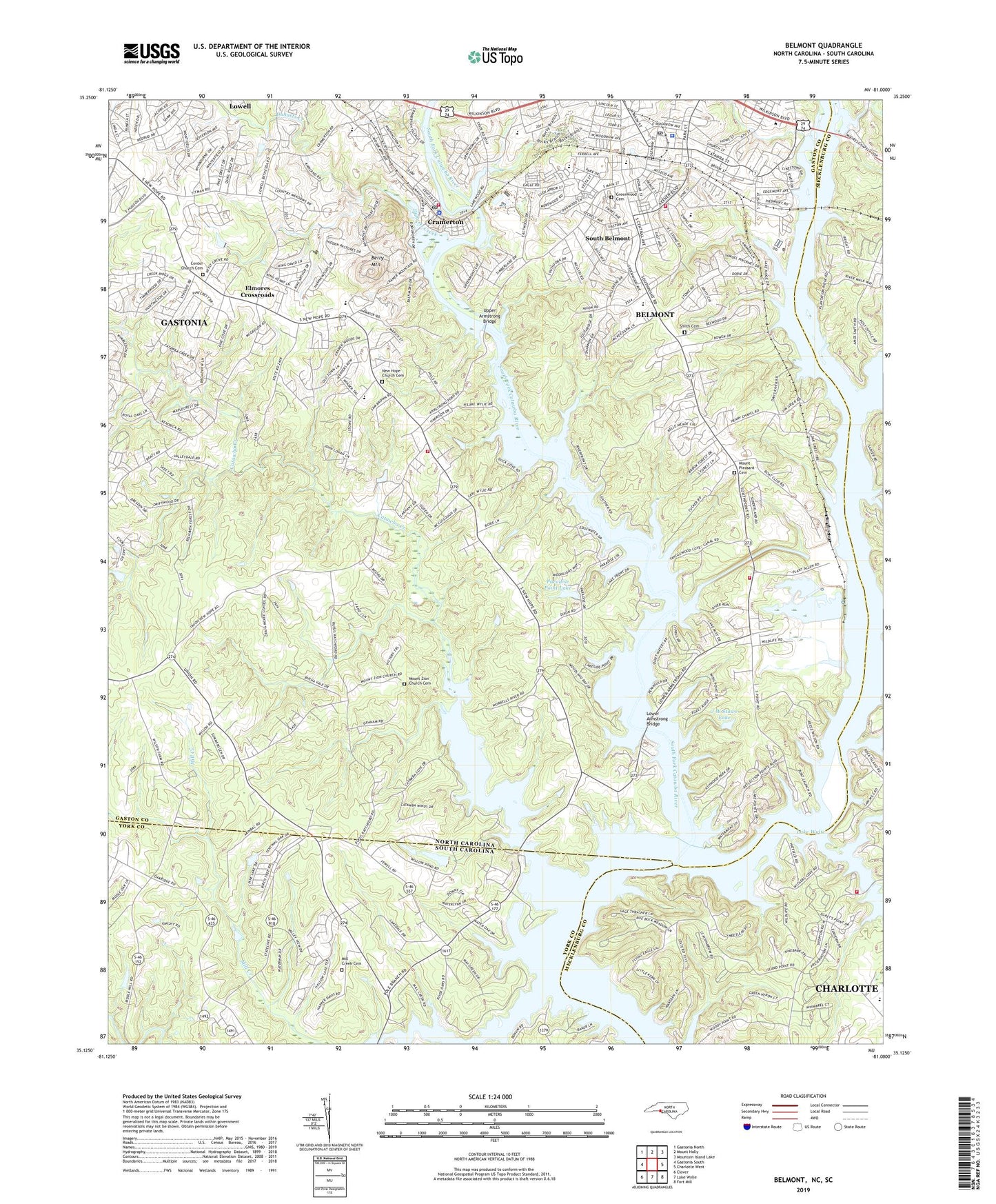
2022 topographic map quadrangle Belmont in the states of North Carolina, South Carolina. Scale: 1:24000. Based on the newly updated USGS 7.5' US Topo map series, this map is in the following counties: Gaston, York, Mecklenburg. The map contains contour data, water features, and other items you are used to seeing on USGS maps, but also has updated roads and other features. This is the next generation of topographic maps. Printed on high-quality waterproof paper with UV fade-resistant inks.
Quads adjacent to this one:
West: Gastonia South
Northwest: Gastonia North
North: Mount Holly
Northeast: Mountain Island Lake
East: Charlotte West
Southeast: Fort Mill
South: Lake Wylie
Southwest: Clover
Contains the following named places: Allen Steam Station Dam Number One, Allen Steam Station Dam Number Two, Armstrongs Ford, Beaverdam Creek, Begonia, Belmont, Belmont Central Elementary School, Belmont Fire Department Station 43, Belmont Junior High School, Belmont Police Department, Belmont Post Office, Berry Mountain, Bethesda Church, Bethesda Tabernacle, Boyd Friendship Church, Catawba, Catawba Creek, Center Church, Center Church Cemetery, Charlotte Fire Department Station 38, City of Belmont, Cramer Mountain, Cramer Mountain Country Club, Cramerton, Cramerton Christian Academy, Cramerton Elementary and Junior High School, Cramerton Police Department, Cramerton Post Office, Cramerton Volunteer Fire Department Station 41, Davis Park, Duharts Creek, East Belmont School, Eastwood Shopping Center, Elmores Crossroads, Gardner Wood, Gaston County EMS Station 4, Gateway Park, Greenwood Cemetery, Hall Airport, Henry Church, J W Stowe Lake, J W Stowe Lake Dam, Lake Wylie Park, Lakewood, Lakewood Golf Course, Little Paw Creek, Loves Chapel, Lower Armstrong Bridge, Mecklenburg County Park, Mill Creek, Mill Creek Cemetery, Monticello Woods, Mount Pleasant Cemetery, Mount Pleasant Church, Mount Zion Church, Mount Zion Church Cemetery, Neal Branch, New Hope Church, New Hope Church Cemetery, New Hope School, New Hope Volunteer Fire Department Station 50, Noname, North Carolina State Wildlife Landing, North Carolina Vocational Textile School, Paradise Point, Paradise Point Dam, Paradise Point Lake, Paw Creek, Sacred Heart College, Smith Cemetery, South Belmont, South Fork Catawba River, South Point Church, South Point High School, South Point Volunteer Fire Department Station 42, Stowe Branch, Town of Cramerton, Township of South Point, Upper Armstrong Bridge, Withers Creek Access Area, ZIP Codes: 28012, 28032, 28278