MyTopo
Newland North Carolina US Topo Map
Couldn't load pickup availability
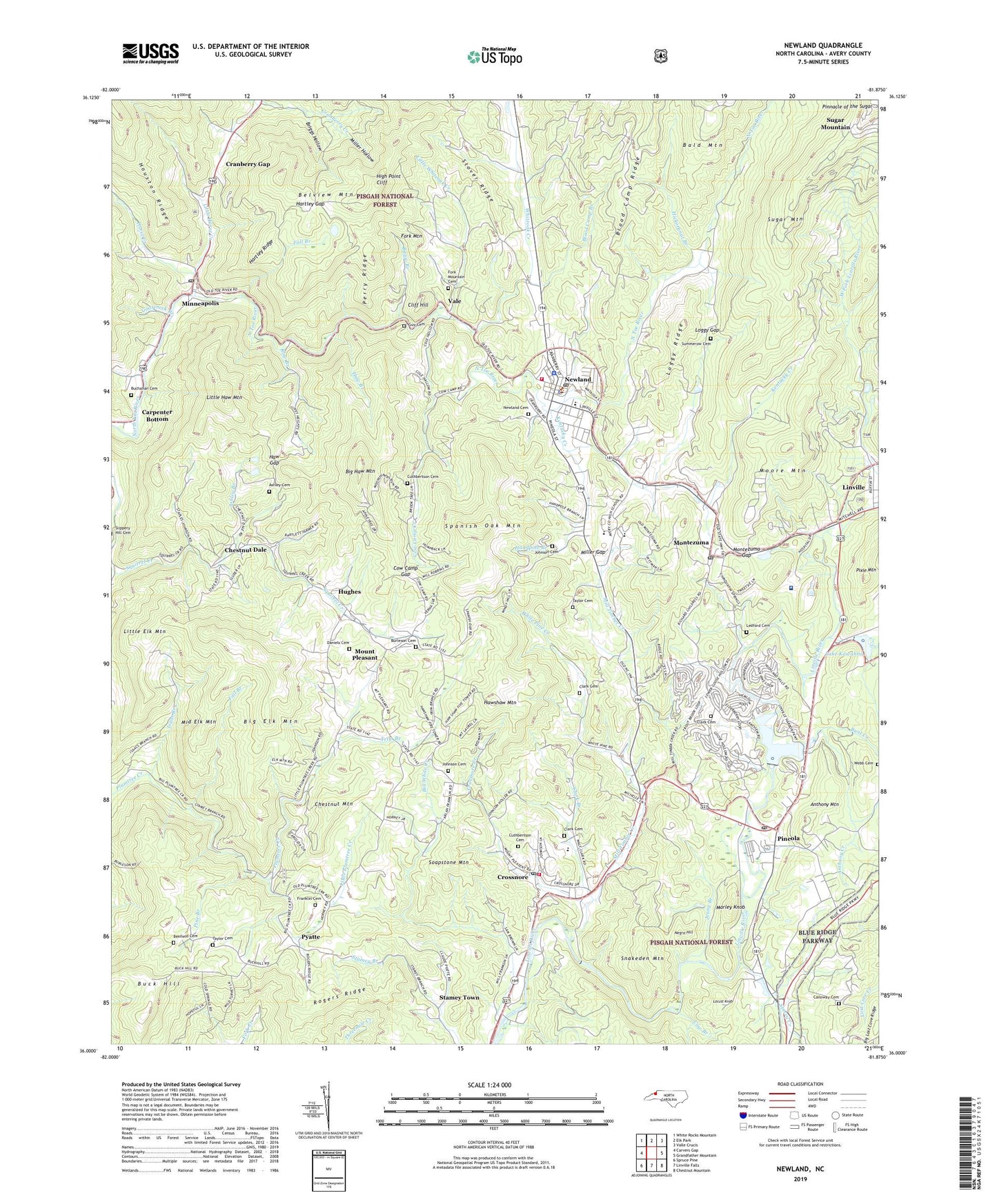
2019 topographic map quadrangle Newland in the state of North Carolina. Scale: 1:24000. Based on the newly updated USGS 7.5' US Topo map series, this map is in the following counties: Avery, Burke. The map contains contour data, water features, and other items you are used to seeing on USGS maps, but also has updated roads and other features. This is the next generation of topographic maps. Printed on high-quality waterproof paper with UV fade-resistant inks.
Quads adjacent to this one:
West: Carvers Gap
Northwest: White Rocks Mountain
North: Elk Park
Northeast: Valle Crucis
East: Grandfather Mountain
Southeast: Chestnut Mountain
South: Linville Falls
Southwest: Spruce Pine
Contains the following named places: Aaron Church, Anthony Creek, Anthony Mountain, Ashley Branch, Ashley Cemetery, Ashley Chapel, Avery County, Avery County Emergency Medical Services - Newland, Avery County High School, Avery County Sheriff's Office, Banjo Branch, Belview Church, Belview Mountain, Benfield Cemetery, Big Branch, Big Elk Mountain, Big Haw Mountain, Big Meadow Church, Bill White Creek, Birchfield Creek, Blood Camp Branch, Briggs Hollow, Buchanan Cemetery, Buck Hill, Buck Hill Church, Buckwheat Branch, Bunt Creek, Burleson Cemetery, Calloway Cemetery, Calvary Church, Camp Carolina, Camp Linn-Haven, Camp Yonahnoka, Carpenter Bottom, Charles Cannon Junior Memorial Hospital, Chestnut Dale, Chestnut Mountain, Clark Branch, Clark Cemetery, Cliff Hill, Cow Branch, Cow Camp Creek, Cow Camp Gap, Cranberry Gap, Crossnore, Crossnore Creek, Crossnore Elementary School, Crossnore Post Office, Crossnore Volunteer Fire Department, Crossnore-Newland Middle School, Cuthbertson Cemetery, Daniels Cemetery, Fall Branch, Fletcher Chapel, Forest Home Church, Fork Mountain, Fork Mountain Cemetery, Franklin Cemetery, Gooseneck Branch, Grandmother Creek, Guy Cemetery, Handpole Branch, Hartley Gap, Hartley Ridge, Haw Branch, Haw Gap, Hawshaw Lookout Tower, Hawshaw Mountain, Hickorynut Branch, High Point Cliff, Horse Creek, Hughes, Isaae Branch, Ivy Heights Church, Jenny Branch, Johnson Cemetery, Kentucky Creek, Lake Kawahna, Land Harbors Lake, Land Harbors Lake Dam, Ledford Cemetery, Linville - Central Rescue Squad, Linville Quarry, Little Elk Mountain, Little Haw Mountain, Little Horse Creek, Little Plumtree Church, Little Plumtree Creek, Little Whiteoak Creek, Locust Knob, Loggy Gap, Loggy Ridge, Long Ridge Church, Marley Knob, Middle Elk Mountain, Midway Church, Mill Timber Creek, Miller Gap, Miller Hollow, Minneapolis, Minneapolis Elementary School, Minneapolis Post Office, Montezuma, Montezuma Gap, Montezuma Post Office, Moore Mountain, Mount Pleasant, Mount Pleasant Church, Negro Hill, New Cross Church, Newland, Newland Cemetery, Newland Elementary School, Newland Police Department, Newland Post Office, Newland Volunteer Fire Department, Oak Grove Church, Perry Ridge, Pine Branch, Pineola, Pineola Post Office, Pinnacle of the Sugar, Pixie Mountain, Pyatte, Rogers Ridge, Row Branch, Sloop Chapel, Sloop Dam, Smoky Valley Chapel, Snakeden Mountain, Soapstone Mountain, Spanish Oak Mountain, Stacey Creek, Stamey Town, Stover Ridge, Sugar Mountain, Sugar Mountain Church, Summerow Cemetery, Taylor Cemetery, Town of Crossnore, Town of Newland, Township of Altamont, Township of Hughes, Township of Montezuma, Township of Newland Number 1, Township of Newland Number 2, Township of Pineola, Township of Pyatte, Trim Branch, Vale, Webb Cemetery, Whitaker Branch, White Pine Creek, Whiteoak Creek, WJTP-AM (Newland), ZIP Codes: 28616, 28652, 28657, 28662