MyTopo
Salisbury North Carolina US Topo Map
Couldn't load pickup availability
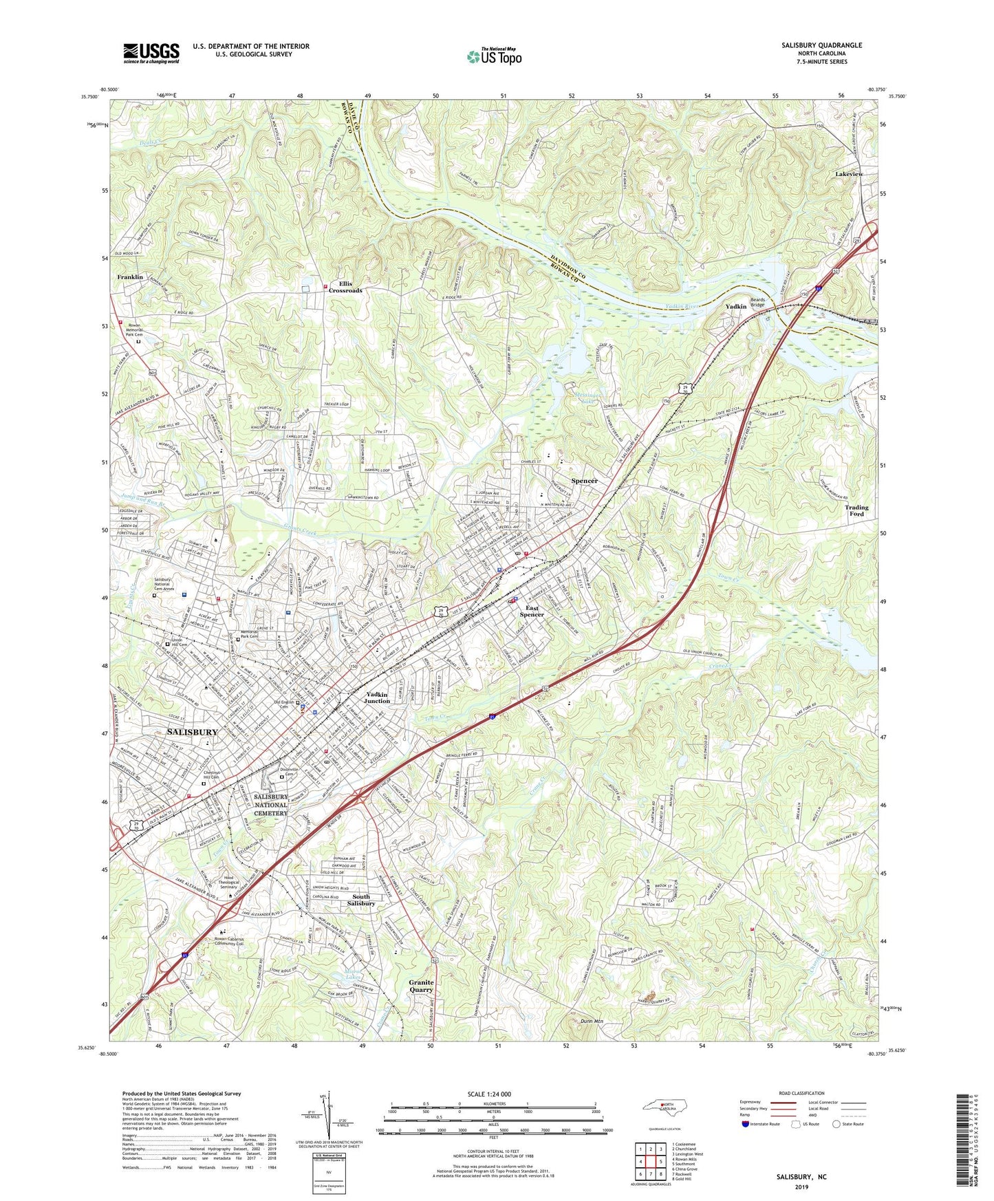
2022 topographic map quadrangle Salisbury in the state of North Carolina. Scale: 1:24000. Based on the newly updated USGS 7.5' US Topo map series, this map is in the following counties: Rowan, Davidson, Davie. The map contains contour data, water features, and other items you are used to seeing on USGS maps, but also has updated roads and other features. This is the next generation of topographic maps. Printed on high-quality waterproof paper with UV fade-resistant inks.
Quads adjacent to this one:
West: Rowan Mills
Northwest: Cooleemee
North: Churchland
Northeast: Lexington West
East: Southmont
Southeast: Gold Hill
South: Rockwell
Southwest: China Grove
This map covers the same area as the classic USGS quad with code o35080f4.
Contains the following named places: A T Allen School, Ballard Industrial School, Beards Bridge, Bellemeade, Belmont, Bethel Church, Boyden High School, Brentwood Acres, Brown Ferry, Calvary Church, Calvary Lutheran Church, Calvin H Wiley School, Cannon Park, Catawba College, Catawba Heights, Cedarcrest, Central United Methodist Church, Chestnut Hill Cemetery, Christ Lutheran Church, Church of Christ, Church of God, Church of the Sacred Heart, City of Salisbury, Coburn Memorial Methodist Church, Coleman Recreational Center, Collins Quarry, Confederate Prison Site, Corbin Hills, Corbin Hills Golf Course, Country Club Hills, Cross Heights, Crystal Pink Quarry, Deals Creek, Dixonville Cemetery, Doctor Josephus Hall House, Dogwood Acres, Dorsett Chapel, Dukeville, Dunbar High School, Dunn Mountain, Dunn Mountain Church, Eagle Heights, Eaman Park, East Spencer, East Spencer Baptist Church, East Spencer Fire Department, East Spencer Graded School, East Spencer Police Department, East Spencer Post Office, Eastbronk, Eastwood Village, Ellis Cross Country Fire Department, Ellis Crossroads, Ellis Park, Emmanuel Baptist Church, Fairview, First Baptist Church, First Calvary Baptist Church, First Methodist Church, First Pilgrim Church, First Presbyterian Church, First United Church of Christ, Forest Hill Park, Forest Hills, Four Square Gospel Church, Franklin, Franklin Mission, Franklin Township Volunteer Fire Department Station 55, Fulton Heights, Gethsemane Baptist Church, Grady Heights, Grants Creek, Grays Chapel, Grimes Mill, Haden Grove Church, Halls Chapel, Hannahs Ferry site, Haven Evangelical Lutheran Church, Henderson School, Historic District, Historical Mint Park, Hood Theological Seminary, Jaycee Optimist Sports Complex, Jefferson Heights, Jersey City Park, Johns School, Jump and Run Branch, Kingdom Hall of Jehovahs Witnesses, Knox Junior High School, Lilys Chapel Holiness Church, Lincoln Park, Lincoln School, Livingstone College, Long Street Methodist Episcopal Church, Long Street Park, Looks Bridge, Ludwick Acres, Mahaley Park, Main Street Church, Maupin Avenue Presbyterian Church, McCall Heights, McCanless Golf Course, Meadowbrook, Memorial Park Cemetery, Messiah Lutheran Church, Messinger Dam, Messinger Lake, Miller Park, Mirror Lakes, Mirror Park, Mocksville, Monroe Street Elementary School, Morlan Park, Mount Calvary Church, Mount Tabor Church, Mount Zion Church, Moyle Heights, New Hope Zion Church, New Zion Church, Newton Heights, North Main Street Baptist Church, North Rowan High School, North Rowan Primary School, Novant Health Rowan Medical Center, Oak Ridge, Oakdale Church, Oakland, Oakland Heights Chapel, Oakland Heights Park, Oakland Park, Old English Cemetery, Old Lutheran Cemetery, Our Lady of Victories Mission, Overton School, Park Avenue Methodist Church, Park Plaza Shopping Center, Park View Heights, Presbyterian Lecture Room, Price High School, Ridgewood, Rowan County Courthouse, Rowan County Jail, Rowan County Rescue Squad, Rowan County Sheriff's Office, Rowan Mall, Rowan Memorial Park Cemetery, Rowan Museum, Rowan Public Library, Rowan Technical College, Rowan Terrace, Sacred Heart School, Saint Johns Chapel, Saint Johns Lutheran Church, Saint Lukes Church, Saint Lukes Episcopal Church, Saint Pauls Episcopal Church, Saint Peters Episcopal Church, Saint Phillips Church, Salisbury, Salisbury Business College, Salisbury Country Club, Salisbury Fire Department Station 1, Salisbury Fire Department Station 3, Salisbury National Cemetery, Salisbury National Cemetery Annex, Salisbury Police Department, Salisbury Post Office, Sandy Ridge Terrace, Second Presbyterian Church, Sedgefield Acres, Shady Grove Baptist Church, Shannon Park, Smith, Smith Grove Baptist Church, Soldiers Memorial African Methodist Episcopal Zion Church, South Salisbury, South Yadkin River, Southern City Tabernacle African Methodist Episcopal Zion Church, Southern Railway Park, Southgate Shopping Center, Southside Church, Spencer, Spencer High School, Spencer Methodist Protestant Church, Spencer Park, Spencer Police Department, Spencer Post Office, Spencer Presbyterian Church, Spencer Volunteer Fire Department, Stallings Memorial Baptist Church, State Transportation Museum, Steel, Steel Worth Park, Sunrise Acres, Town Creek, Town of East Spencer, Town of Spencer, Towne Mall, Township of Salisbury, Trinity United Presbyterian Church, Union Church, Union Hill Cemetery, Union Terrace, Union Volunteer Fire Department Station 76 Union, United House of Prayer, W.G. Hefner Veterans Affairs Medical Center, Wallace Building, Wesleyan Church, Whiteheads Mill, WNDN-FM (Salisbury), Woodbine, Yadkin, Yadkin Junction, YMCA, Zion Baptist Church, Zion Church, ZIP Codes: 28039, 28144, 28159