MyTopo
Whittier North Carolina US Topo Map
Couldn't load pickup availability
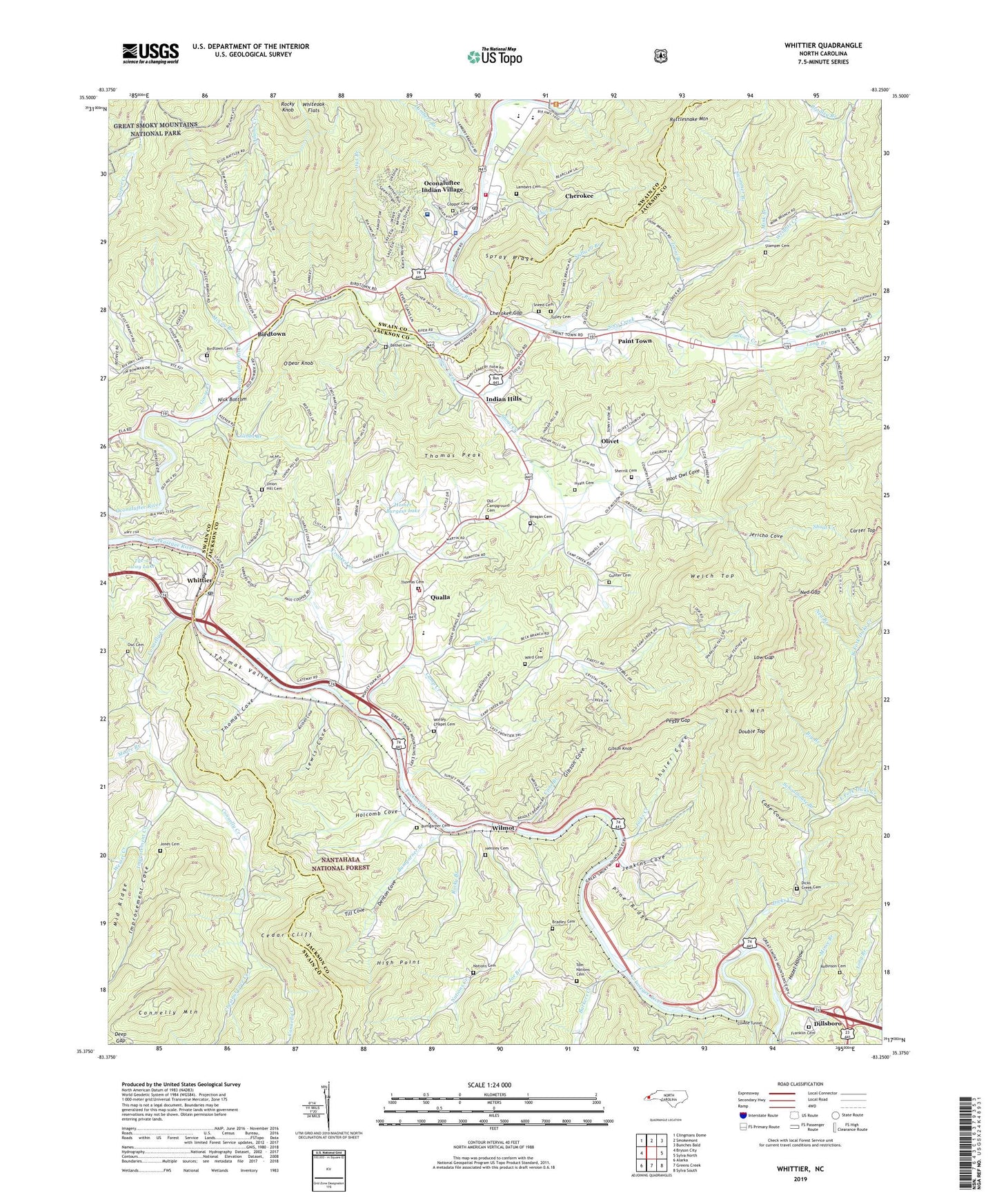
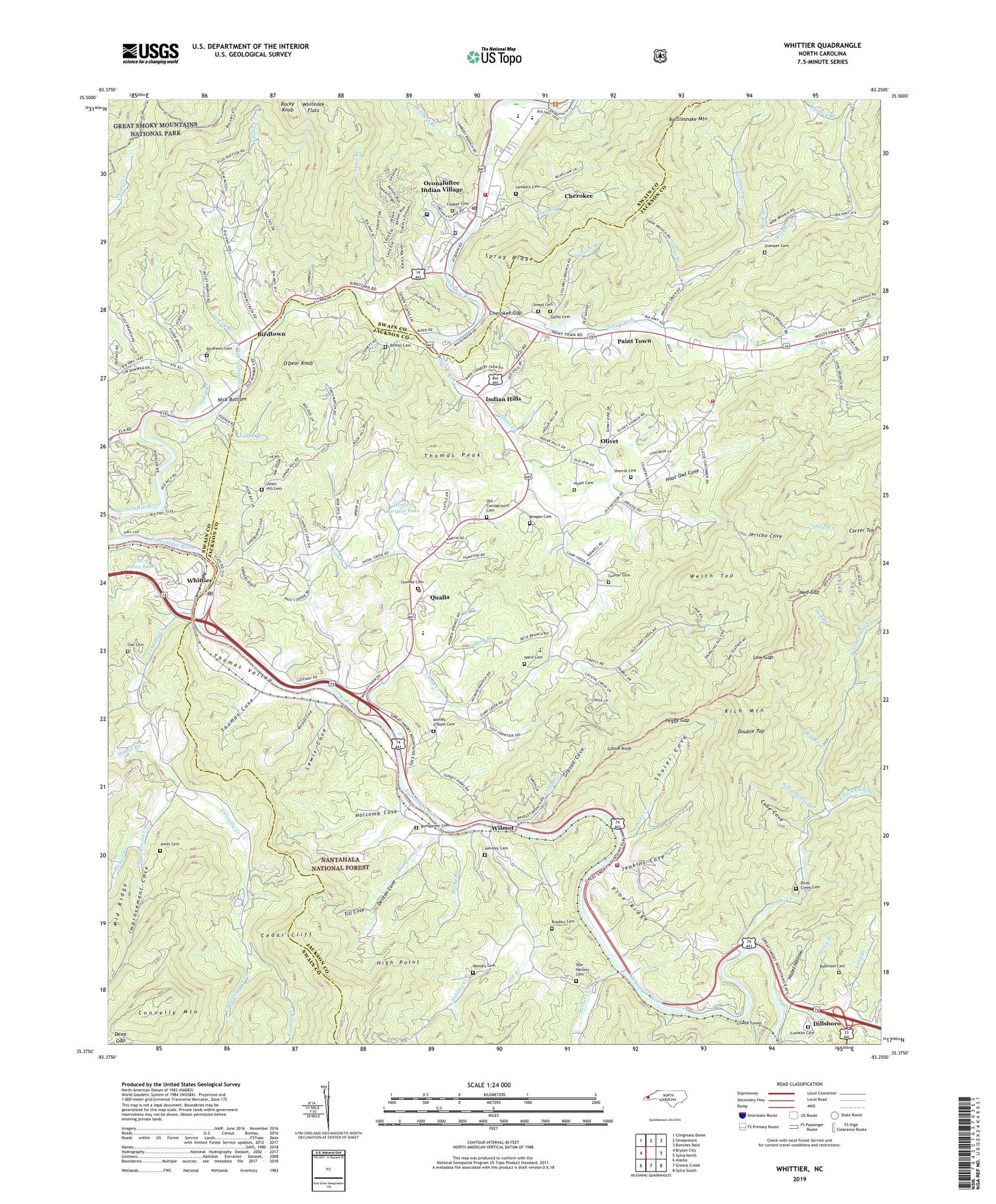
2019 topographic map quadrangle Whittier in the state of North Carolina. Scale: 1:24000. Based on the newly updated USGS 7.5' US Topo map series, this map is in the following counties: Jackson, Swain. The map contains contour data, water features, and other items you are used to seeing on USGS maps, but also has updated roads and other features. This is the next generation of topographic maps. Printed on high-quality waterproof paper with UV fade-resistant inks.
Quads adjacent to this one:
West: Bryson City
Northwest: Clingmans Dome
North: Smokemont
Northeast: Bunches Bald
East: Sylva North
Southeast: Sylva South
South: Greens Creek
Southwest: Alarka
Contains the following named places: Adams Creek, Barkers Creek, Beck Branch, Bethabara Church, Bethel Cemetery, Big Branch, Big Witch Creek, Birdtown, Birdtown Cemetery, Birdtown Community, Bradley Branch, Bradley Cemetery, Buckeye Branch, Bumgarner Branch, Bumgarner Cemetery, Cabe Cove, Camp Creek, Cane Branch, Carter Top, Cedar Cliff, Cherokee, Cherokee Census Designated Place, Cherokee Church, Cherokee Fire Department, Cherokee Fire Department Station 2, Cherokee Gap, Cherokee Indian Hospital, Cherokee Indian Reservation, Cherokee Police Department, Cherokee Post Office, Cherokee Tribal Emergency Medical Services, Chestnut Cove Creek, Connelly Creek, Connelly Creek Church, Connelly Mountain, Copper Cemetery, Cowee Tunnel, Crooked Creek, Deep Gap, Deep Gap Branch, Denton Cove, Dicks Creek, Dicks Creek Cemetery, Dicks Creek Church, Double Top, East Fork Dicks Creek, Eastern Cherokee Reservation, Franklin Cemetery, Frontierland, Gateway, Gibbs Branch, Gibson Cove, Gibson Knob, Goose Creek, Gunter Cemetery, Hazel Hollow, Hensley Cemetery, High Point, Holcomb Cove, Homer Burgess Dam, Homer Burgess Lake, Hoot Owl Cove, Hyatt Cemetery, Hyatt Chapel Church, Improvement Cove, Improvement Creek, Indian Hills, Jacks Creek, Jenkins Cove, Jericho Cove, Joe Branch, Jones Cemetery, Kitchen Cove, Lambert Branch, Lambert Cemetery, Laurel Branch, Lewis Cove, Log Cabin School, Long Branch, Long Branch Church, Low Gap, Macedonia Church, Mainey Branch, McCoy Branch, Mince Branch, Mink Branch, Moore Branch, Mount Noble Lookout Tower, Mountainside Theater, Nations Cemetery, Nations Creek, Ned Branch, Ned Gap, Nick Bottom, Oconaluftee Indian Village, Oconaluftee Lake, O'Dear Knob, Old Campground Cemetery, Olivet, Our Lady of Guadalupe Church, Owl Branch, Owl Cemetery, Paint Town, Painttown Community, Patterson Chapel Church, Peggy Gap, Pine Ridge, Qualla, Qualla Housing Project, Qualla Volunteer Fire Department, Qualla Volunteer Fire Department Station 2, Rattlesnake Mountain, Reagan Cemetery, Rich Mountain, Robinson Cemetery, Rock Hill Church, Rock Springs Church, Rocky Branch, Rocky Knob, Saint Francis of Assisi Church, Santa's Land, Schoolhouse Branch, Sherrill Cemetery, Shoal Creek, Shoal Creek Church, Shuler Cove, Smoky Mountain Elementary School, Sneed Cemetery, Soco Community Center, Soco Creek, Spray Ridge, Stamper Cemetery, Stillwell Branch, Swimmer Branch, Thomas Cemetery, Thomas Cove, Thomas Peak, Thomas Valley, Till Cove, Tolley Cemetery, Tom Nations Cemetery, Tooni Branch, Township of Barkers Creek, Township of Qualla, Tuc-a-way Lake, Union Hill Cemetery, Ward Cemetery, Water Falls Church, Welch Top, Wesser Creek, West Fork Dicks Creek, Whiteoak Flats, Whittier, Whittier Census Designated Place, Whittier Elementary School, Whittier Post Office, Williams Branch, Wilmot, Worley Chapel Cemetery, Wrights Creek, Wrights Creek Church, Yellow Hill Church, Yellowhill Community, ZIP Code: 28789