MyTopo
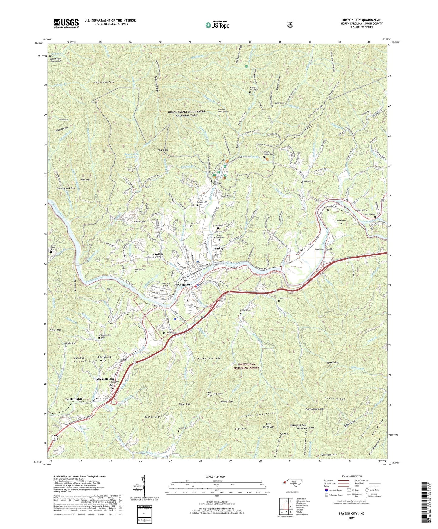
Bryson City North Carolina US Topo Map
Couldn't load pickup availability
Also explore the Bryson City Forest Service Topo of this same quad for updated USFS data
2022 topographic map quadrangle Bryson City in the state of North Carolina. Scale: 1:24000. Based on the newly updated USGS 7.5' US Topo map series, this map is in the following counties: Swain. The map contains contour data, water features, and other items you are used to seeing on USGS maps, but also has updated roads and other features. This is the next generation of topographic maps. Printed on high-quality waterproof paper with UV fade-resistant inks.
Quads adjacent to this one:
West: Noland Creek
Northwest: Silers Bald
North: Clingmans Dome
Northeast: Smokemont
East: Whittier
Southeast: Greens Creek
South: Alarka
Southwest: Wesser
This map covers the same area as the classic USGS quad with code o35083d4.
Contains the following named places: Antioch Church, Arlington Church, Baines Mountain, Battle Cove, Beaugard Ridge, Betts Branch, Blankenship Cemetery, Bryson Branch, Bryson City, Bryson City Dam, Bryson City Fire Department, Bryson City Police Department, Bryson City Post Office, Bryson City Reservoir, Buckhorn Ridge, Buckner Branch, Bumgardner Branch, Buzzardroost Mountain, Camp Living Water, Cherokee Indian Reservation 3200 Acre Tract, Cochran Branch, Cold Springs Church, Cooper Cemetery, Cooper Creek, Cowstamp Mountain, Cripple Creek, Dancing Branch, Davis Gap, De Hart Branch, De Hart Cemetery, De Hart Mill, Deep Creek, Deep Creek Campground, Deep Creek Cemetery, Deep Creek Church, Deep Creek Group Camp, Dog Cove, Durham Branch, East Alarka Church, Easy Ridge Gap, Ela, Estes Cemetery, Falls Branch, Ferguson Field Municipal, Fishtrap Branch, Franklin Grove, Frisbee Branch, Fry Mountain, Frye Mountain Lookout, Galbraith Cemetery, Galbraith Church, Galbraith Creek, Gibby Branch, Governors Island, Governors Island Church, Hammer Branch, Hammer Branch Cemetery, Hayes Ridge, Hickorynut Gap, Hickorynut Knob, Hickorynut Mountain, Hillside Church, Holly Spring Church, Hughes Branch, Indian Creek, Jackson Line, Jenkins Branch, Jenkins Cemetery, Jenkins Place, Johnson Branch, Juney Whank Branch, Kelly Bennett Peak, Kirkland Cemetery, Kirkland Creek, Lackey Hill, Lands Creek, Laney Cemetery, Laurel Branch, Laurel Branch Cemetery, Lemmons Branch, Little Alarka Creek, Little Peachtree Creek, Long Branch, Maple Branch, McHan Cemetery, Messer Branch, Middle Peachtree Creek, Middle Ridge, Milksick Cove, Mine Mountain, Morning Star Church, Morrow Cemetery, Mount Carmel Church, Mountain Branch, Oconaluftee River, Odear Cove, Ogle Knob, Parkview Church, Peachtree Creek, Queen - Lower Indian Creek Cemetery, Queen Branch, Randall Cemetery, Rattlesnake Knob, Rich Mountain, Robinson Branch, Robinson Gap, Rock Creek Church, Rocky Face Mountain, Saint Joseph Church, Scarred Branch, Sharp Top, Shepherd Creek, Sherrill Cemetery, Sherrill Gap, Shuler Gap, Silvermine Branch, Sitton Creek, Sossamon Field, Spruce Grove Church, Sutton Cemetery, Swain Community Hospital, Swain County, Swain County Emergency Medical Services, Swain County High School, Swain County Rescue Squad, Swain County Sheriff's Office, Swain Memorial Cemetery, Terrell Gap, Thomas Chapel, Tom Branch, Toot Hollow Branch, Town of Bryson City, Tuckasegee Dock, Upper Noland - Branton Cemetery, Valley Village Shopping Center, Victory Church, Watkins Branch, Watkins Cemetery, WBHN-AM (Bryson City), Welch Branch, Wiggins - Watson Cemetery, Wiggins Branch, Wiggins No 2 Cemetery, Will Gap, Will Knob, Worley Branch, Worley Knob