MyTopo
Wilson North Carolina US Topo Map
Couldn't load pickup availability
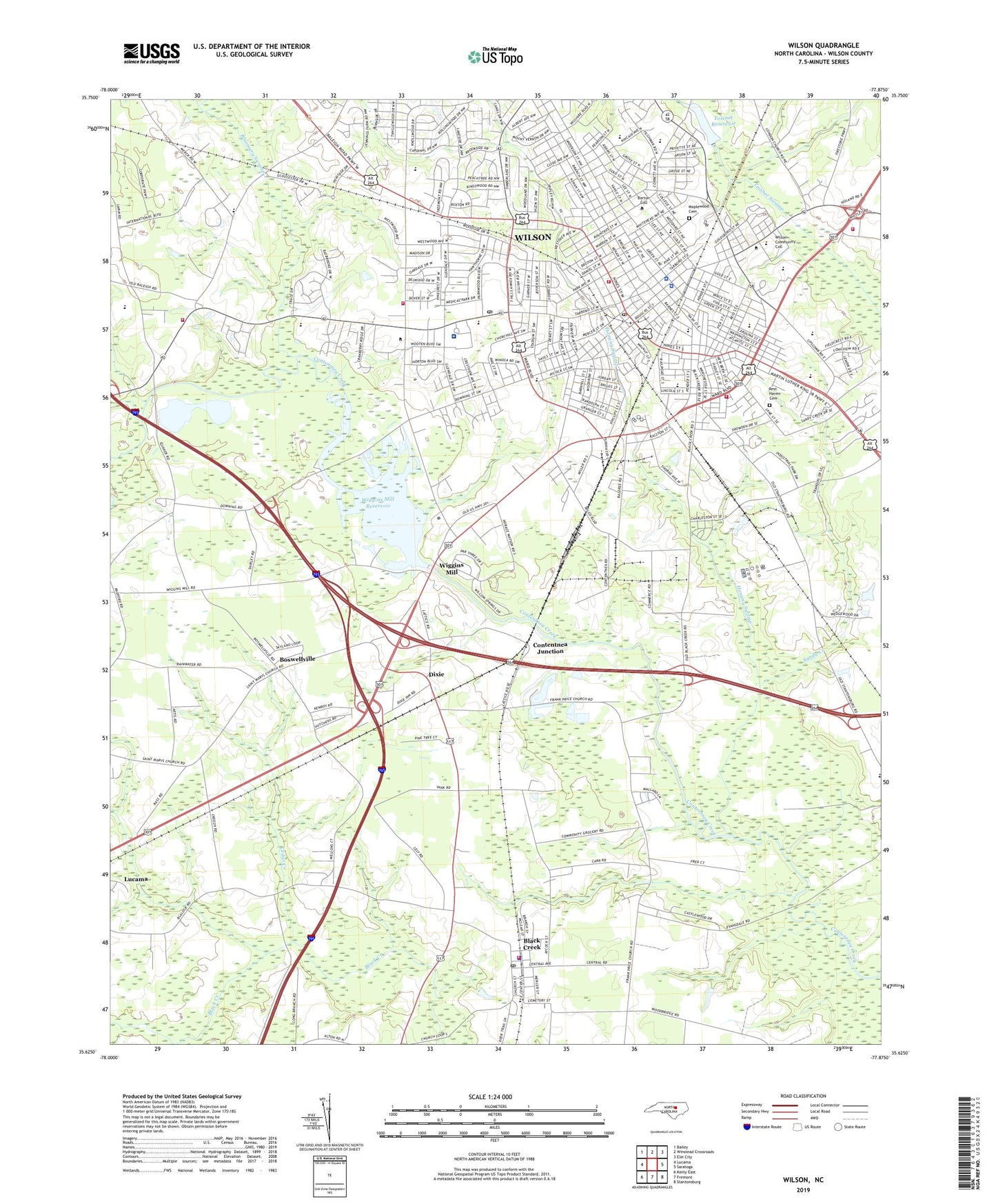
2022 topographic map quadrangle Wilson in the state of North Carolina. Scale: 1:24000. Based on the newly updated USGS 7.5' US Topo map series, this map is in the following counties: Wilson. The map contains contour data, water features, and other items you are used to seeing on USGS maps, but also has updated roads and other features. This is the next generation of topographic maps. Printed on high-quality waterproof paper with UV fade-resistant inks.
Quads adjacent to this one:
West: Lucama
Northwest: Bailey
North: Winstead Crossroads
Northeast: Elm City
East: Saratoga
Southeast: Stantonsburg
South: Fremont
Southwest: Kenly East
This map covers the same area as the classic USGS quad with code o35077f8.
Contains the following named places: A P Simpson House, Adams School, Barnes School, Barton College, Beddingfield High School, Bel-Air Forest, Belle Meade, Black Creek, Black Creek Police Department, Black Creek Post Office, Black Creek Volunteer Fire Department, Bloomery Swamp, Boswellville, Boulevard Plaza, Breckenridge, British Woods, Brookside Manor, Bunches Church, Cavalier Park, Cavalier Terrace, Cedar Creek, City of Wilson, Contentnea Junction, Contentnea Volunteer Fire Department, Coon School, Crestview, Criminal Division, Daniels Chapel, Darden High School, Davis-Whitehead-Harris House, Dixie, Doctor William S Anderson House, E L Jordan House, East Nash Volunteer Fire Department Substation, Eastern North Carolina School for Deaf, Edgewood, Elvie Street School, Farmington Heights, Farrior Park, Five Points, Fleming Stadium, Forest Hills, Forest Hills Park, Forrest Road Homes, Friendship Church, Glenwood Hills, Gold Park Shopping Center, Greenfield School, Happy Valley Country Club, Hearne School, Hominy Heights, Hominy Swamp, Hotel Cherry, Imperial Estates, James Rountree House, Jennings Acres, Johnston Ambulance Service, JR Boykin-Haywood Edmundson House, Judge H G Connor House, Kings Plaza, Law Enforcement Center, Lincoln Heights, Living Hope Church, Longleaf Neuro - Medical Treatment Center, Lower Black Creek Church, Lucas-Barnes House, Maplewood Cemetery, Mill Branch, Millbrook, Montclair, North Carolina State Highway Patrol Troop C District 5, Oakforest, Parkwood Mall, Parkwood Post Office, Patterson Chapel, Pinewood Estates, Quail Hollow, Quail Ridge, Regency Plaza, Rest Haven Cemetery, Saint Johns Church, Saint Pauls Church, Saint Timothys Episcopal Church, Sandy Creek, Seven Hills, Shepard Branch, Temple Church, Toisnot Park, Toisnot Reservoir, Town of Black Creek, Township of Black Creek, Township of Wilson, Trinity Church, Valleydale Estates, Vick School, Vinson-Bynum School, Washington Place, Waterford, Wedgewood Country Club, Wells School, Westwood, Whitfield Homes, Wiggins Mill, Wiggins Mill Reservoir, Wiggins Millpond Dam, Wiggins-Hadley House, Wilco Industrial Park, Wilco Manor Mobile Home Park, Wildwood, Wilkins-Walston House, Wilson, Wilson Christian School, Wilson County, Wilson County Department of Emergency Medical Services, Wilson County Rescue Squad, Wilson County Sheriff's Office, Wilson County Speedway, Wilson County Technical Institute, Wilson Medical Center, Wilson Police Department, Wilson Post Office, Wilson Primitive Baptist Church, Wilson Rescue Fire Department Station 1, Wilson Rescue Fire Department Station 2, Wilson Rescue Fire Department Station 3, Wilson Theatre, Winoca Shopping Center, Winstead School, WLLY-AM (Wilson), Woodard School, Woodfield, WVOT-AM (Wilson), WXYY-FM (Wilson), ZIP Codes: 27813, 27893