MyTopo
Bellbrook Ohio US Topo Map
Couldn't load pickup availability
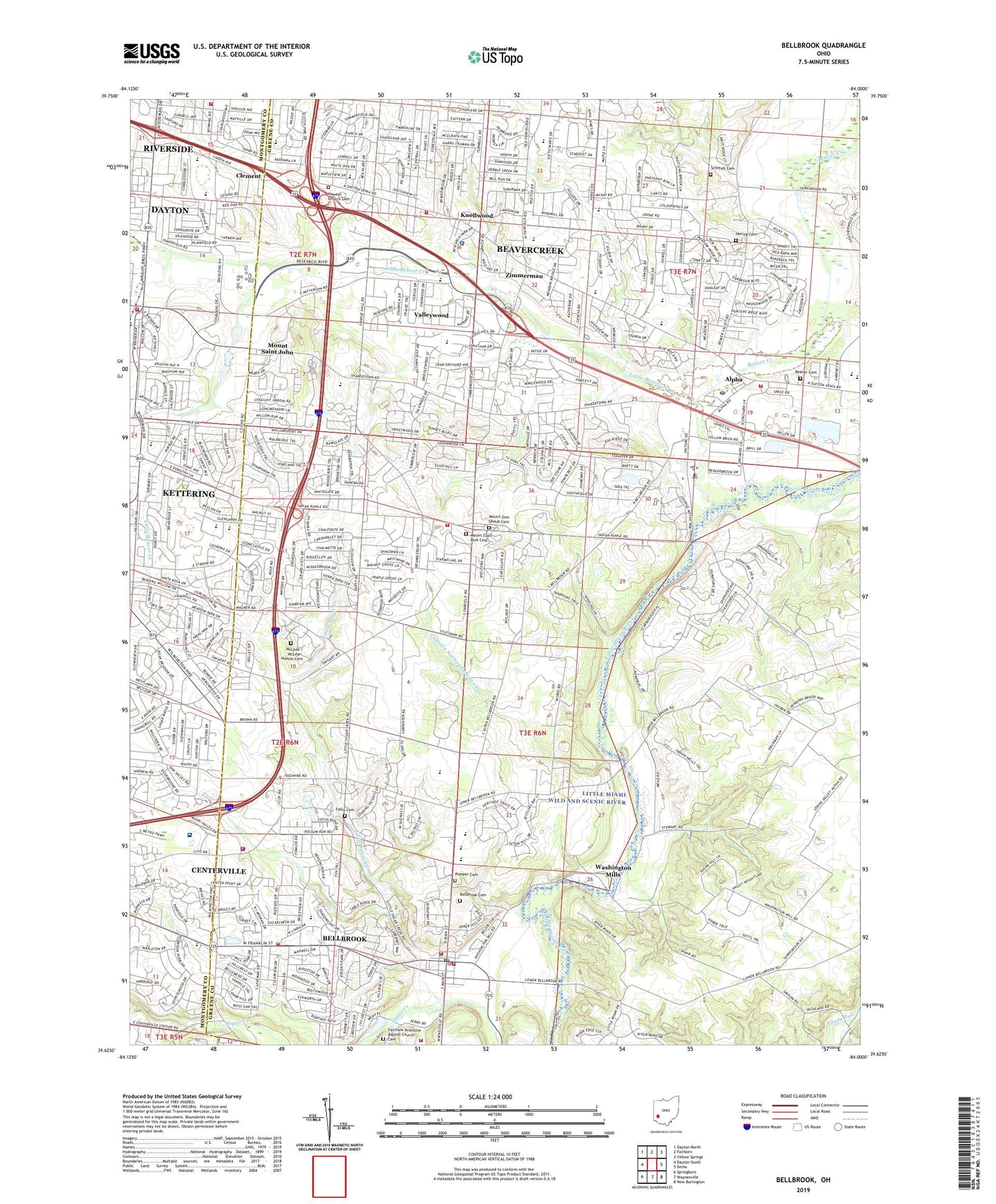
2023 topographic map quadrangle Bellbrook in the state of Ohio. Scale: 1:24000. Based on the newly updated USGS 7.5' US Topo map series, this map is in the following counties: Greene, Montgomery. The map contains contour data, water features, and other items you are used to seeing on USGS maps, but also has updated roads and other features. This is the next generation of topographic maps. Printed on high-quality waterproof paper with UV fade-resistant inks.
Quads adjacent to this one:
West: Dayton South
Northwest: Dayton North
North: Fairborn
Northeast: Yellow Springs
East: Xenia
Southeast: New Burlington
South: Waynesville
Southwest: Springboro
This map covers the same area as the classic USGS quad with code o39084f1.
Contains the following named places: Alpha, Alpha Post Office, Beaver Cemetery, Beaver Creek, Beaver Valley Shopping Center, Beavercreek, Beavercreek Church, Beavercreek High School, Beavercreek Plaza Shopping Center, Beavercreek Police Department, Beavercreek Post Office, Beavercreek Township Fire Department Station 61, Beavercreek Township Fire Department Station 62, Beavercreek Township Fire Department Station 64, Beavercreek Valley School, Bellbrook, Bellbrook Cemetery, Bellbrook Fire Department Station 2, Bellbrook Fire Dept Station 1, Bellbrook High School, Bellbrook Police Department, Bellbrook Post Office, Birchwood Club, Black Oak East Park, Captain Nathan Lammes Creek, Carroll High School, Charles I Beaver Park, Cherry Hill Church, Cinnamon Creek Park, City of Beavercreek, City of Bellbrook, Claypool Heliport, Clement, Clemmer School, Cloverbrook Park, Crestview Nursing Home, Dayton State Hospital Farm, Dayton Sugarcreek Office Park, East Dayton Baptist Church, Eastmont Elementary School for Environmental Science, Eastmont Freewill Baptist Church, Eastmont United Methodist Church, Fairbrook Elementary School, Fairview Church, Fairview Primitive Baptist Church Cemetery, Fallis Cemetery, Farther School, Furgerson Junior High School, Hawker Cemetery, Hawker Church, Hering Cemetery, Herman K Ankeney Junior High School, Huffman Dam, Huffman Reservoir, Huston Cemetery, Indian Riffle Junior High School, Indian Riffle Park, Indian Riffle Shopping Center, J E Prass Elementary School, Kettering Fire Department Station 34, Kettering Junior High School, Knollwood, Knollwood Shopping Center, Lantz School, Lebanon Junction, Lewton Elementary School, Little Beaver Creek, Little Sugar Creek, Marianists College, McLane / McLean-Huston Cemetery, Merrick Park, Miami Valley Hospital South, Miami Valley Research Park, Morgan Cemetery, Mount Saint John, Mount Zion Church, Mount Zion Park Cemetery, Mount Zion Shoup Cemetery, Oak Creek Park, Oak Creek School, Park Layne Park, Parkwood Elementary School, Pelbrook Community Shopping Center, Pioneer Cemetery, Plasco Field Heliport, Pondview Park, Riverside Fire Department Station 6, Rollandia Golf Course, Rolling Field School, Rosewood School, Rotary Park, Saint Lukes School, Schmidt Cemetery, School Number 1, School Number 4, Shoup Park, Spaulding Road Church of God, Spring Lake Park, Stephen Bell Elementary School, Sugarcreek Education Center, Sugarcreek Elementary School, Sugarcreek Reserve, Sugarcreek Township Fire Department - Station 2, Sugarcreek Township Fire Department and Emergency Medical Services - Station 1, Sugarcreek Township Police Department, Sugarvalley Country Club, Sweet Arrow Farm, The Narrows State Scenic River Reserve, Township of Beavercreek, Valleywood, Virgillato Park, Walnut Grove Country Club, Washington Mills, West School, Whites Corner, Whites School, Will Grove Golf Club, Wilmington Heights Shopping Center, Woodlane Plaza Shopping Center, Zimmerman, Zimmerman Post Office, ZIP Codes: 45301, 45305, 45430, 45432, 45434, 45440