MyTopo
Crooksville Ohio US Topo Map
Couldn't load pickup availability
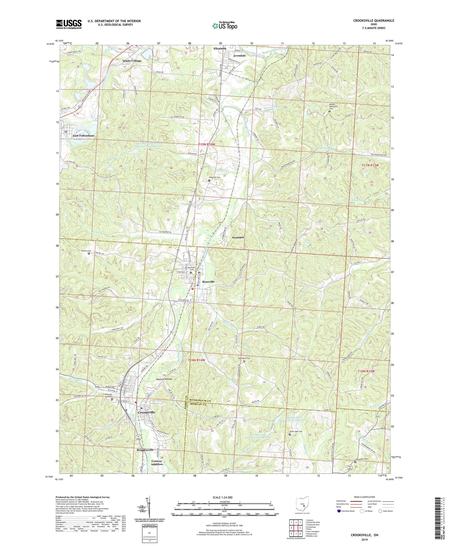
2023 topographic map quadrangle Crooksville in the state of Ohio. Scale: 1:24000. Based on the newly updated USGS 7.5' US Topo map series, this map is in the following counties: Muskingum, Perry, Morgan. The map contains contour data, water features, and other items you are used to seeing on USGS maps, but also has updated roads and other features. This is the next generation of topographic maps. Printed on high-quality waterproof paper with UV fade-resistant inks.
Quads adjacent to this one:
West: Fultonham
Northwest: Gratiot
North: Zanesville West
Northeast: Zanesville East
East: Philo
Southeast: Rokeby Lock
South: Deavertown
Southwest: New Lexington
This map covers the same area as the classic USGS quad with code o39082g1.
Contains the following named places: Avondale, Avondale Wildlife Area Dam Number One, Avondale Wildlife Area Dam Number Two, Avondale Wildlife Area Reservoir Number One, Avondale Wildlife Area Reservoir Number Two, Bells School, Bethel Church, Bethel Methodist Cemetery, Black Fork, Black Oak Cemetery, Blackoak School, Brigglesville, Buckeye Fork, Burley Run, Church of Atonement, Claypit Creek, Conway Addition, Crooksville, Crooksville Baptist Church, Crooksville Cemetery, Crooksville Fire Department, Crooksville Police Department, Crooksville Post Office, Crooksville Reservoir Number One, Crooksville Reservoir Number One Dam, Crooksville Reservoir Number Two, Crooksville Reservoir Number Two Dam, Crooksville Water Treatment Plant, East Fultonham, East Fultonham Census Designated Place, East Fultonham Post Office, East Fultonham School, Ebenezer Cemetery, Ebenezer Church, Ebenezer School, Elk Run, First United Methodist Church, Flint Ridge School, France School, Franklin Avenue Church of Christ, Haverhill School, Horne, Huggins School, Ironspot, Jenkins School, Jerusalem Cemetery, Jerusalem Evangelical Lutheran Church, Jonathan Creek, Kent Run, Lake Isabel, Larzelere School, Maple Avenue Christian Church, Morrison Run, Newton Elementary School, Newton Township Fire Department, Ohio Historical Society Pottery Museum, Old Stone House, Owens Cemetery, Porter Run, Possum Hollow, Reese School, Riders Run, Roberts, Rose Hill Cemetery, Roseville, Roseville Cemetery, Roseville Elementary School, Roseville Police Department, Roseville Post Office, Roseville Primary School, Roseville Volunteer Fire Department, Saint Pauls Lutheran Church, Saint Pauls United Methodist Church, Snake Run, Township of Clay, Township of Harrison, Township of Newton, United Brethren Church, Village of Crooksville, Village of Roseville, White Cottage, Wigton School, WYBZ-FM (Crooksville), ZIP Codes: 43735, 43777