MyTopo
Zanesville East Ohio US Topo Map
Couldn't load pickup availability
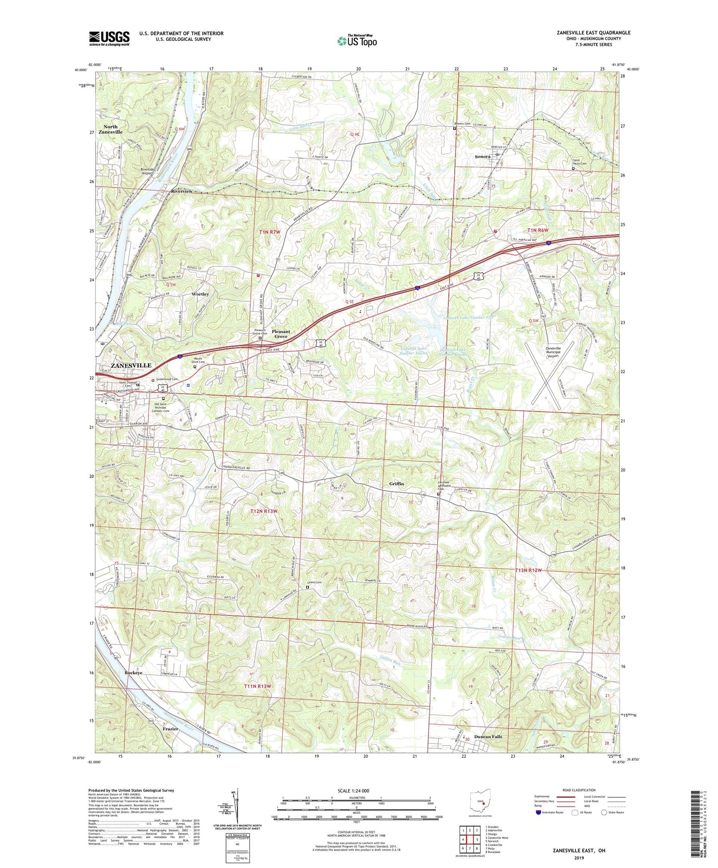
2023 topographic map quadrangle Zanesville East in the state of Ohio. Scale: 1:24000. Based on the newly updated USGS 7.5' US Topo map series, this map is in the following counties: Muskingum. The map contains contour data, water features, and other items you are used to seeing on USGS maps, but also has updated roads and other features. This is the next generation of topographic maps. Printed on high-quality waterproof paper with UV fade-resistant inks.
Quads adjacent to this one:
West: Zanesville West
Northwest: Dresden
North: Adamsville
Northeast: Otsego
East: Norwich
Southeast: Ruraldale
South: Philo
Southwest: Crooksville
This map covers the same area as the classic USGS quad with code o39081h8.
Contains the following named places: Boggs Creek, Bowers Cemetery, Brookover, Brush Creek, Buckeye, C M Luburgh Estate Pond Number 9717-005 Dam, C M Luburgh Estate Pond Number 9717-011 Dam, Calvert Park, Carlwick, Carlwick Post Office, Duncan Falls Census Designated Place, Duncan Falls Primary School, Eastlynd Acres, Fairview Methodist Cemetery, Fairview School, Flat Run, Forest Hills, Frazier, Georgetown, Greenwood Cemetery, Griffin, Hague School, Hidden Mound, Holiday Inn Heliport, Homestead Hills, Indian Run, Jackson, Jackson School, Jaycee Riverside Park, Lewis Cemetery, Lewis School, Luburgh Lake Number Eleven, Luburgh Lake Number Five, Luburgh Lake Number Twelve, Manns Fork Salt Creek, McDonald's Greenhouse, McKinley Elementary School, Mid-East Ohio Vocational School, Mill Run, Monroe School, Mount Olive Cemetery, Muskingum County, Muskingum County Sheriff's Office, Muskingum Sanitary Landfill, North Zanesville Census Designated Place, Oakland, Ohio State Highway Patrol - Zanesville Patrol Post, Old Saint Nicholas Catholic Cemetery, Parkinson School, Paul Mine, Peregoy School, Perry Township Fire Department, Petro Heliport, Pierce, Pioneer Park, Pleasant Grove, Pleasant Grove Cemetery, Pleasant Grove Census Designated Place, Pleasant Grove Elementary School, Pleasant Grove United Methodist Church, Riverside Airport, Riverview, Robertson School, Rosecrans High School, Rural Chapel, Saint Nicholas School, Saint Pauls Cemetery, Saint Thomas Cemetery, Sharon Avenue Free Methodist Church, Sheridan School, Sonora, Sonora Post Office, Sonora School, Southern Meadows, Spring Valley, Story School, Sunrise Shopping Center, Tile, Township of Washington, Township of Wayne, Washington Township Volunteer Fire Department, WCVZ-FM (South Zanesville), WHIZ-AM (Zanesville), WHIZ-FM (Zanesville), WHIZ-TV (Zanesville), Willow Lakes, Wortley, Zane Street Post Office, Zanesville Municipal Airport, ZIP Codes: 43701, 43734