
MyTopo
Defiance East Ohio US Topo Map
Couldn't load pickup availability
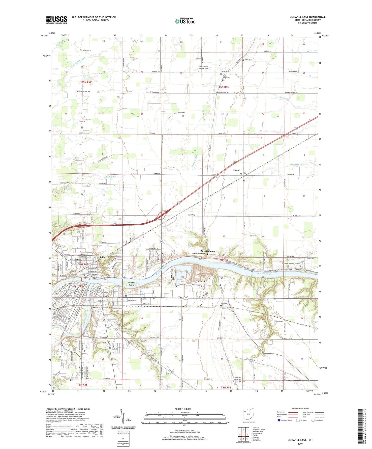
2023 topographic map quadrangle Defiance East in the state of Ohio. Scale: 1:24000. Based on the newly updated USGS 7.5' US Topo map series, this map is in the following counties: Defiance. The map contains contour data, water features, and other items you are used to seeing on USGS maps, but also has updated roads and other features. This is the next generation of topographic maps. Printed on high-quality waterproof paper with UV fade-resistant inks.
Quads adjacent to this one:
West: Defiance West
Northwest: Evansport
North: Ridgeville Corners
Northeast: Napoleon West
East: Florida
Southeast: New Bavaria
South: Ayersville
Southwest: Junction
This map covers the same area as the classic USGS quad with code o41084c3.
Contains the following named places: Agape Lighthouse Church, Apostolic United Pentecostal Church, Auglaize River, Ayersville Cemetery, Bethel Christian Assembly Church, Bethel Spanish Church, Brickell Elementary School, Central School, Church of God, City of Defiance, Compo Park, Defiance, Defiance Church of the Brethren, Defiance Church of the Nazarene, Defiance College, Defiance County Childrens Home, Defiance County Courthouse, Defiance County Sheriff's Office, Defiance Fire and Rescue Division, Defiance Hall, Defiance High School, Defiance Junior High School, Defiance Police Department, Defiance Post Office, Defiance Public Library, Defiance Seventh Day Adventist Church, Derges Orchard, Diehl Park, Faith Tabernacle, First Assembly of God Church, First Baptist Church, First Church of Christ, First Evangelical Methodist Church, First Mennonite Church, First Pilgrim Holiness Church, First Presbyterian Church, Fort Defiance, Foster Cemetery, Fred Brown Stadium, General Motors Powertrain Fire Brigade, Good Samaritan School, Grace Episcopal Church, Green Acres Mobile Home Park, Grove Street Church of God, Hire Cemetery, Hohenberger Cemetery, Hohenberger Trailer Court, Holgate Avenue Historic District, Iglesia De Dios, Independence, Independence Cemetery, Independence Dam, Independence Dam State Park, Independence Reservoir, Independence United Methodist Church, Island Park, Jewell, Jewell Fire Department, Jewell Post Office, Jewell United Brethren Church, Justin F Coressel Stadium, Kahol Cemetery, Kettenring Hills Dam, Kettenring Hills Lake, Kingsberry Park, Latty Grove Park, Mattock Ditch, McReynolds Hall, Mercy Health - Defiance Hospital, Midway, Missionary Church of Christ, North Town Estates, Northtowne Mall Shopping Center, Oldfort Defiance Park, Papaik Shopping Center, Pontiac Park, Poplar Ridge Cemetery, Poplar Ridge Church of the Brethren, Presbyterian Cemetery, Preston Island, Preston Run, Richland Adams School, Richland Township Fire Department, Riverside Park, Riverview Memory Gardens, Rohn Cemetery, Rose Field, Saint John Lutheran Church, Saint John United Church of Christ, Saint Johns Catholic Church, Saint Johns School, Saint Marys Catholic Church, Saint Marys School, Saint Michaels Catholic Cemetery, Saint Michaels Catholic Church, Saint Michaels School, Saint Paul Lutheran Church, Saint Pauls United Methodist Church, Schauffler Hall, Second Baptist Church, Second Ward Park, Slocum Elementary School, Spencer Elementary School, Spring Meadows, Stevens Pond, Stevens Pond Dam, Sun Rise Plaza Shopping Center, Tanby Ditch, Tenzer Hall, The Church of Jesus Christ of Latter Day Saints, Tinora Elementary School, Tinora High School, Tittle Cemetery, Township of Richland, Trinity United Methodist Church, Whitney Hall, Williamstown, Zion Lutheran Church, ZIP Code: 43512


