MyTopo
Lancaster Ohio US Topo Map
Couldn't load pickup availability
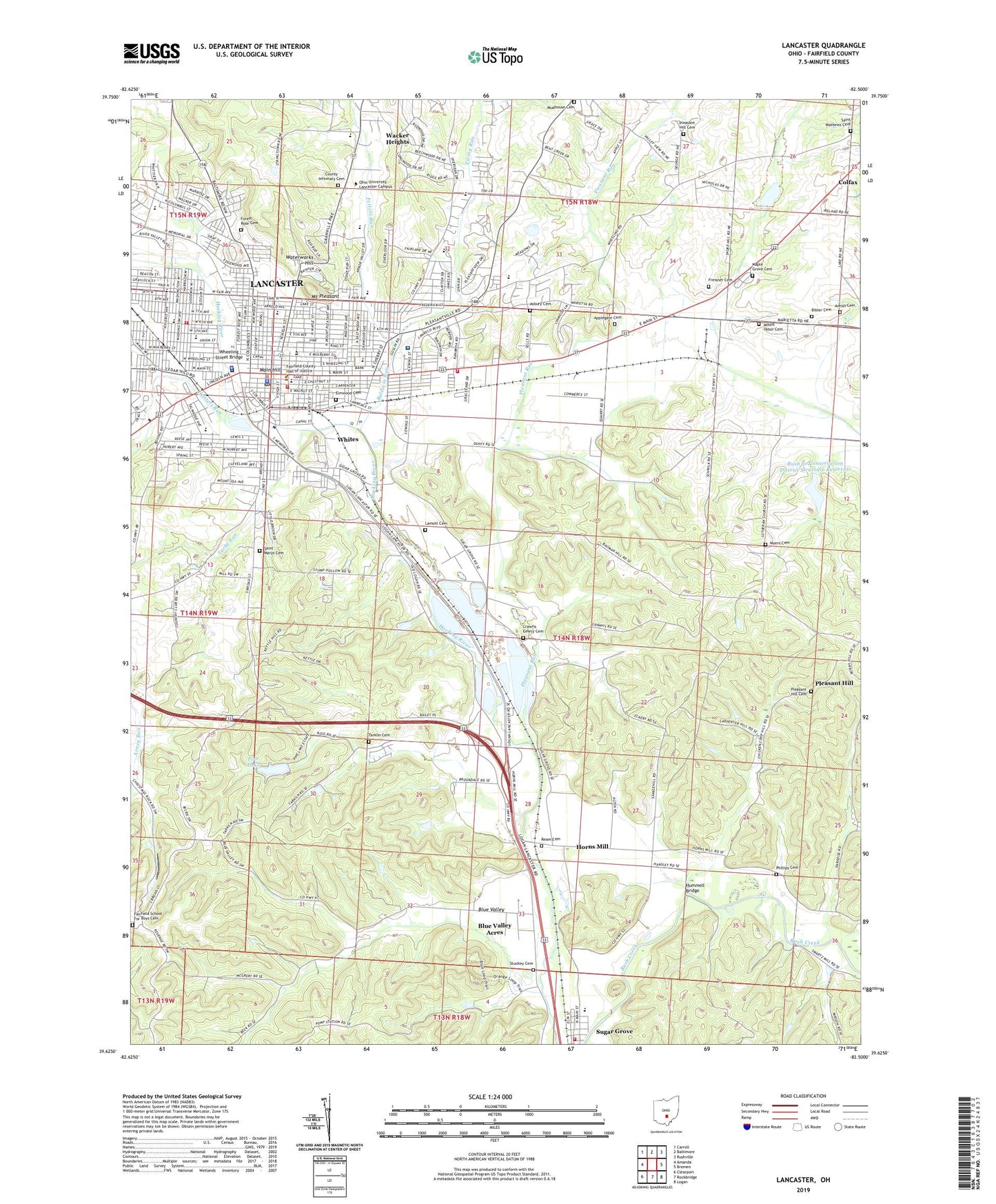
2023 topographic map quadrangle Lancaster in the state of Ohio. Scale: 1:24000. Based on the newly updated USGS 7.5' US Topo map series, this map is in the following counties: Fairfield. The map contains contour data, water features, and other items you are used to seeing on USGS maps, but also has updated roads and other features. This is the next generation of topographic maps. Printed on high-quality waterproof paper with UV fade-resistant inks.
Quads adjacent to this one:
West: Amanda
Northwest: Carroll
North: Baltimore
Northeast: Rushville
East: Bremen
Southeast: Logan
South: Rockbridge
Southwest: Clearport
This map covers the same area as the classic USGS quad with code o39082f5.
Contains the following named places: Allen Chapel African Methodist Episcopal Church, Alley Park, Amish Cemetery, Applegate Cemetery, Asbury Cemetery, Baldwin Run, Berne Township Fire Department, Berne Union Elementary School, Berne Union High School, Bibler Cemetery, Bishop Fenwick High School, Blue Valley, Blue Valley Acres, B'nai Israel Congregation, Boka Woods Number One Dam, Boka Woods Number One Reservoir, Brookdale Mobile Home Park, Burnham Park, Calvary Orthodox Lutheran Church, Camp Anderson, Carpenters Addition, Cedar Heights Elementary School, Cenci Lake Park, Church of Christ, Church of the Nazarene, City of Lancaster, Colfax, Colfax Post Office, Colony Village Mobile Home Park, Columbus Camp, Community Church, County Infirmary Cemetery, Crawfis Emery Cemetery, Deeds Field, Deffenbaugh Park, East Elementary School, East End Industrial Park, East Main Shopping Center, East Side Industrial Park, Eckerts Siding, Elmwood Cemetery, Elmwood Park, Emanuel Lutheran Church, Ewing Run, Fairfield County Childrens Home, Fairfield County Courthouse, Fairfield County Fairgrounds, Fairfield County Home, Fairfield County Jail, Fairfield County Library, Fairfield County Mental Health and Retardation Center, Fairfield County Sheriff's Office, Fairfield Medical Center, Fairfield School For Boys Cemetery, Fetters Run, Fifth Avenue Church of Christ, Firehouse Park, First Apostolic Church, First Church of Christ Scientist, First English Lutheran Church, First Pilgrim Holiness Church, First Presbyterian Church, First United Methodist Church, Forest Rose Cemetery, Freisner Cemetery, General Sherman Junior High School, Glassco Park, Good Shepherd Chapel, Grace United Church of Christ, Harts Shopping Center, Hocking Park, Hocking Valley Mall Shopping Center, Horns Mill, Howes Academy, Huffer Durdin Park, Hummell Bridge, Hunter Park, Hunters Run, Lamott Cemetery, Lancaster, Lancaster Apostolic Assembly Church, Lancaster City Hall, Lancaster Country Club, Lancaster Fire Department Station 1, Lancaster Fire Department Station 2, Lancaster Fire Department Station 3 and Headquarters, Lancaster High School, Lancaster Historic District, Lancaster Mobile Estates, Lancaster Plaza Shopping Center, Lancaster Police Department, Lancaster Post Office, Lancaster West Main Street Historic District, Lanreco Park, Maher Park, Main Hill, Main Street Church of God, Maple Grove Cemetery, Maple Street Evangelical United Brethren Church, Medill Elementary School, Mid - Ohio Ambulance Service, Miller Park, Mills Memorial United Methodist Church, Mount Pleasant, Mount Tabor Cemetery, Mudhouse Cemetery, Myers Cemetery, North Elementary School, North Field, Ochs Fruit Farm, Ohio University-Lancaster, Old City Burying Ground, Olivedale Park, Park Street Hospital, Phillips Cemetery, Pilgrim Holiness Church, Pine Lake, Pine Lake Estates, Pine Lake Estates Dam, Plaza Shopping Center, Pleasant Hill, Pleasant Hill Cemetery, Pleasant Hill United Methodist Church, Pleasant Run, Ream Cemetery, Redeemer School, Reorganized Church of Jesus Christ of Latter Day Saints, Rest-over Trailer Park, Rising Park, River Valley Plaza Shopping Center, Rush Creek Conservation District Structure 7d Dam, Rush Creek Conservation District Structure Reservoir, Saint Johns Episcopal Church, Saint Mary Roman Catholic Church, Saint Marys Cemetery, Saint Marys School, Saint Mathews Cemetery, Saint Paul Church, Saint Paul Lutheran Church, Saint Peter Lutheran Church, Sanderson Elementary School, Sandstone, Schmelzer's Greenhouse, Sherman House State Memorial, Sixth Avenue Methodist Church, Skyview Drive-In, South Elementary School, Southeastern Ohio State Training Center, Square 13 Historic District, Stanberry High School, Stuckey Cemetery, Sugar Grove, Tallmadge Elementary School, Tarhe Elementary School, Tarhe Run, Tarhe Town, Tarklin Cemetery, Taylor Mobile Home Park, Thomas Ewing Junior High School, Town and County Plaza Shopping Center, Township of Berne, Township of Lancaster City, Utica Park, Utica School, Valley View Golf Course, Village of Sugar Grove, Wacker Heights, Wacker Park, Wahkeena Nature Preserve, Waterworks Hill, West Elementary School, West Side Branch Library, WFCO-FM (Lancaster), Wheeling Street Bridge, Whites, William V Fisher Catholic High School, WSWZ-FM (Lancaster), Yogi's Mobile Home Park, Zane Park, ZIP Codes: 43130, 43155