MyTopo
Pomeroy Ohio US Topo Map
Couldn't load pickup availability
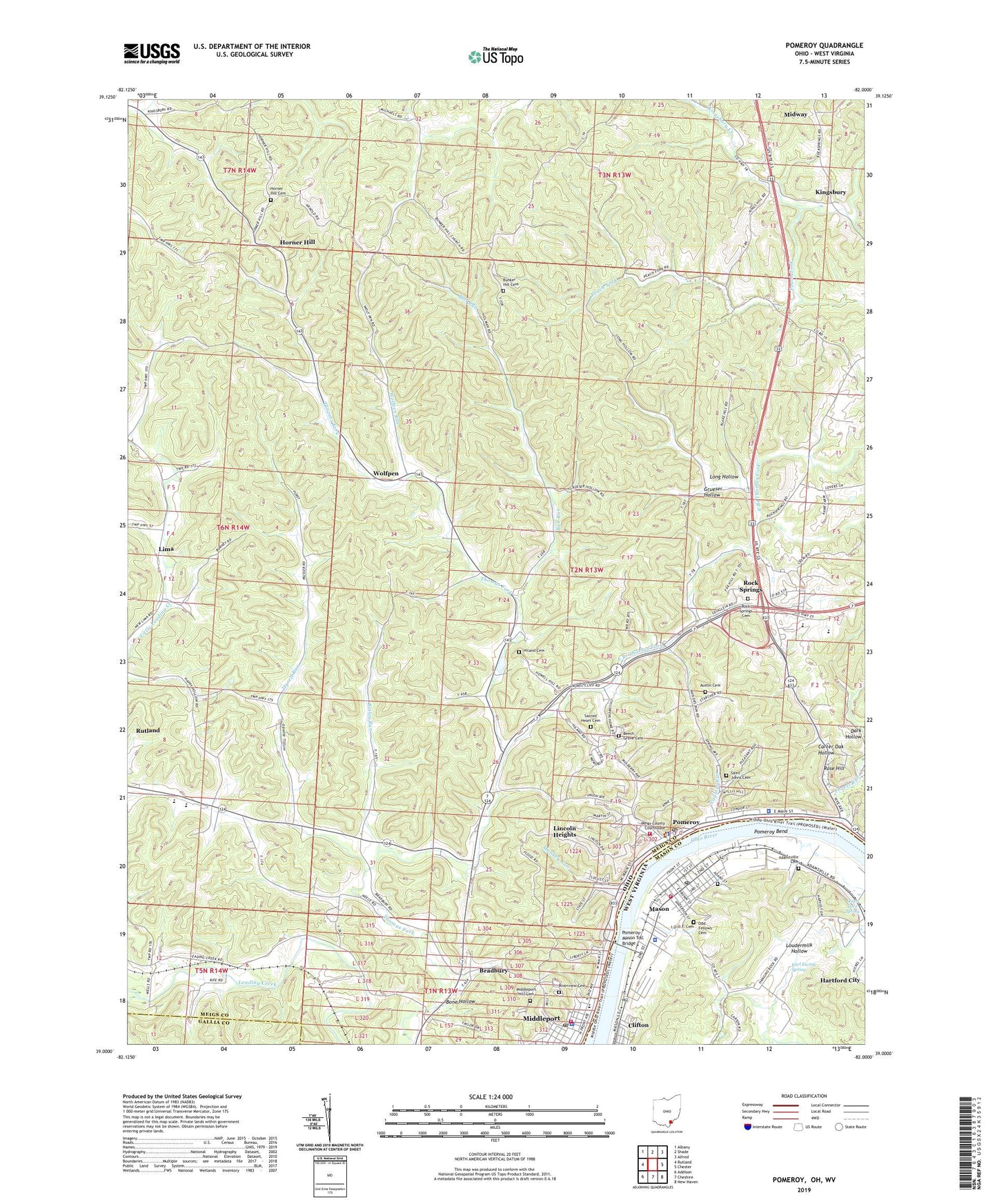
2023 topographic map quadrangle Pomeroy in the states of Ohio, West Virginia. Scale: 1:24000. Based on the newly updated USGS 7.5' US Topo map series, this map is in the following counties: Meigs, Mason, Gallia. The map contains contour data, water features, and other items you are used to seeing on USGS maps, but also has updated roads and other features. This is the next generation of topographic maps. Printed on high-quality waterproof paper with UV fade-resistant inks.
Quads adjacent to this one:
West: Rutland
Northwest: Albany
North: Shade
Northeast: Alfred
East: Chester
Southeast: New Haven
Southwest: Addison
Contains the following named places: Adamsville Cemetery, Austin Cemetery, Bailey Run, Ball Run, Beech Grove Cemetery, Bethel Methodist Episcopal Church, Bone Hollow, Bradbury, Bradbury Elementary School, Bradbury Post Office, Bradford Church, Browntown, Bunker Hill, Bunker Hill Cemetery, Bunker Hill Church, Carter Oak Hollow, Clifton, Clifton Census Designated Place, Earl Ewing Spring, East Branch Thomas Fork, Ed's Greenhouses, Enterprise United Methodist Church, First Baptist Church of Middleport, Forest Run, Grace Episcopal Church, Grueser Hollow, Hiland Cemetery, Hiland Chapel Methodist Church, Hiland School, Horner Hill, Horner Hill Cemetery, Hysell Run, Hysell Run Methodist Church, I.O.O.F. Cemetery, Kerrs Run, Kingsbury, Kingsbury Office, Laurel Cliff Free Methodist Church, Lima, Lincoln Heights, Long Hollow, Loudermilk Hollow, Mason, Mason City Public Library, Mason County Emergency Ambulance Service Authority 500, Mason Elementary School, Mason Police Department, Mason Post Office, Mason Volunteer Fire Department, Meigs County, Meigs County Emergency Medical Services, Meigs County Emergency Medical Services Station 11, Meigs County Fairgrounds, Meigs County Sheriff's Office, Meigs High School, Middleport, Middleport Fire Department and Emergency Medical Services Department, Middleport Hill Cemetery, Middleport Post Office, Middleport Village Police, Midway, Monkey Run, Morris Chapel, Naylors Run, Odd Fellows Cemetery, Oxan Love Spring, Peach Fork, Pomeroy, Pomeroy Bend, Pomeroy Elementary School, Pomeroy Emergency Squad, Pomeroy Fire Department, Pomeroy High School, Pomeroy Historic District, Pomeroy Police Department, Pomeroy Post Office, Pomeroy Seventh Day Adventist Church, Pomeroy United Methodist Church, Pomeroy-Mason Seaplane Base, Pomeroy-Mason Toll Bridge, Riverside Golf Club, Riverview Cemetery, Rock Springs, Rock Springs Cemetery, Rock Springs Post Office, Rock Springs United Methodist Church, Rose Hill, Sacred Heart Cemetery, Saint Johns Cemetery, Saint Josephs Cemetery, Saint Paul Lutheran Church, Salisbury Elementary School, Sugar Run Elementary School, Thomas Village, Town of Mason, Township of Salisbury, Trinity Congregational Church, Veterans Memorial Hospital, Village of Pomeroy, Wahama Junior / Senior High School, WMPO-AM (Middleport-Pomeroy), WMPO-FM (Middleport), Wolfpen, Wolfpen Post Office, Wolfpen Run, Zion Church, ZIP Codes: 25247, 25260, 45760, 45769