MyTopo
Weirton West Virginia US Topo Map
Couldn't load pickup availability
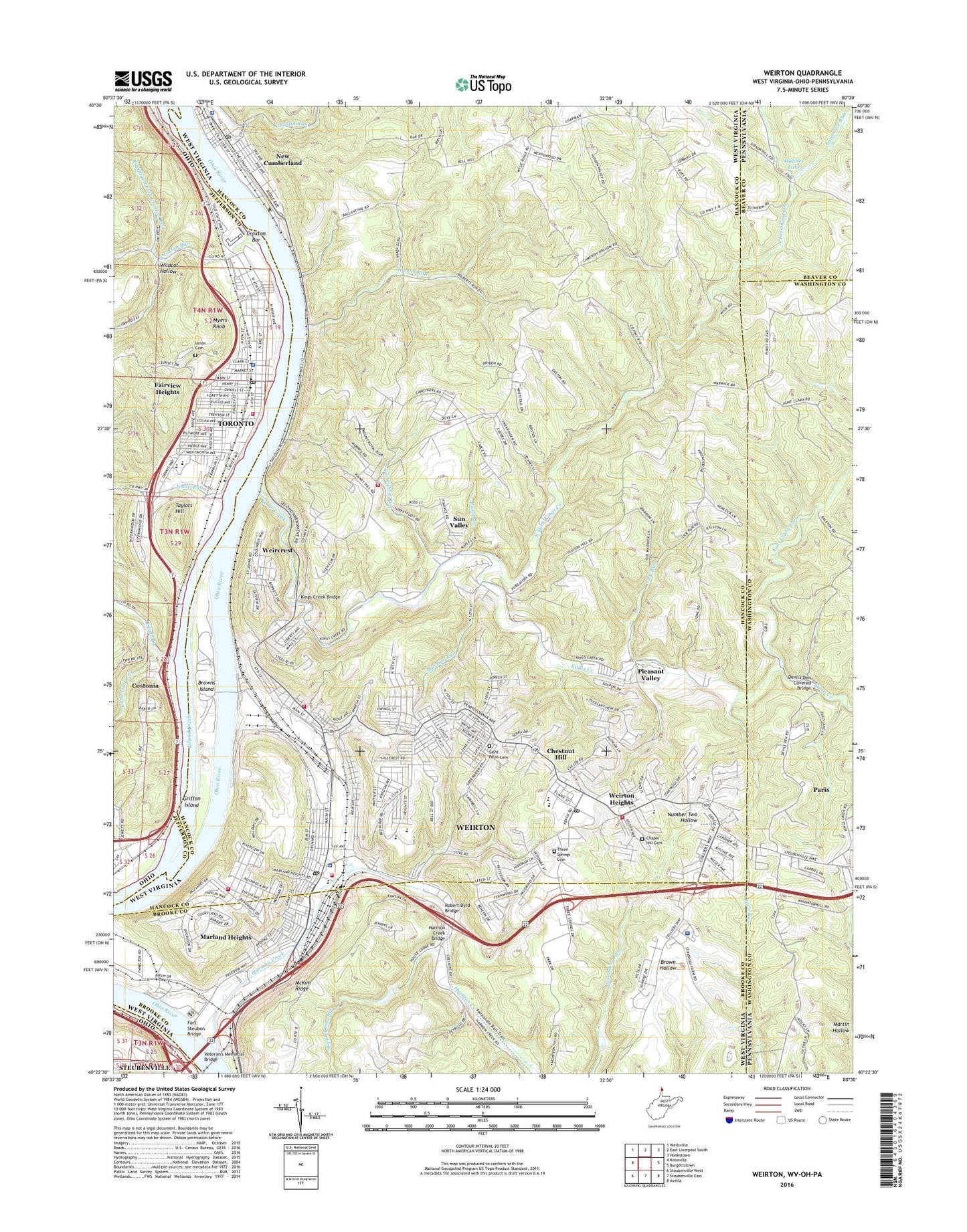
2023 topographic map quadrangle Weirton in the states of West Virginia, Pennsylvania, Ohio. Scale: 1:24000. Based on the newly updated USGS 7.5' US Topo map series, this map is in the following counties: Hancock, Brooke, Jefferson, Washington, Beaver. The map contains contour data, water features, and other items you are used to seeing on USGS maps, but also has updated roads and other features. This is the next generation of topographic maps. Printed on high-quality waterproof paper with UV fade-resistant inks.
Quads adjacent to this one:
West: Knoxville
Northwest: Wellsville
Northeast: Hookstown
East: Burgettstown
Southeast: Avella
Southwest: Steubenville West
This map covers the same area as the classic USGS quad with code o40080d5.
Contains the following named places: Alexanders Run, All Saints Greek Orthodox Church, Antonian Dining Hall, Assumption of the Blessed Virgin Mary Greek Catholic Church, Aunt Clara Fork, Beth Israel Synagogue, Blackhorse, Braithewaite, Broadview Elementary School, Browns Island, Butler District, Calumet, Calumet Post Office, Central Junior High School, Central School, Chapel Hill Cemetery, Chelsea, Chestnut Hill, Christ Apostolic Temple, Christ the King Chapel, Church of Christ, Church of the Nazarene, City of New Cumberland, City of Toronto, City of Weirton, Clay District, Costonia, Costonia Post Office, Cove Post Office, Cove School, Cove United Presbyterian Church, Croxton Bar, Croxton Run, Devils Den, Devil's Den Covered Bridge, Dunbar School, Edgewood Primary School, Fairview Heights, Finnegan Fieldhouse, First Assembly of God Church, First Baptist Church, First Christian Church, First Presbyterian Church of Toronto, First United Methodist Church, First United Methodist Church of Toronto, Fort Steuben Bridge, Franciscan University of Steubenville, Franklin School, Freemans, Freemans Landing, Gospel Hall, Griffen Island, Half Moon Industrial Park, Hancock County Courthouse, Hancock County Sheriff's Office, Harmon Creek, Harmon Creek Bridge, Harmon Creek Structure Number 14 Dam, Harmon Creek Structure Number One Dam, Holbert Run, Holidays Cove, Hollidays Cove Post Office, Holy Spirit Monastery, Hughes Lake, Island Creek, J C Williams Center, Jeddo Run, Jefferson School, John Paul II Library, Kaul Wildlife Area, Kingdom Hall of Jehovahs Witnesses, Kings Creek, Kings Creek Bridge, Kings Creek Chapel, Kmart Plaza, Lauretta B Millsop Primary School, Lawrence Run, Liberty Elementary School, Lick Run, Lincoln Elementary School, Little Island Creek, Logrow, Maranatha Assembly of God Church, Margaret M Weir Park, Marian Hall, Markle, Marland Heights, Marland Heights Elementary School, Marrow Run, Mary H Weir Public Library, McKim Ridge, Memorial Baptist Church, Memorial Park, Mercy Baptist Academy, Millsop School, Mount Olive Baptist Church, Mountaineer Woodview Golf Course, Myers Knob, New Cumberland, New Cumberland Ambulance Service, New Cumberland Elementary School, New Cumberland Junction, New Cumberland Police Department, New Cumberland Post Office, North Fork Kings Creek, North River Avenue Church of Christ, Northside Church of God, Oakland Church, Oakland District Volunteer Fire Department, Old Meridian Monument, Paris, Paris Census Designated Place, Pleasant Valley, Pleasant Valley Country Club, Pleasant Valley Country Club Golf Course, Pleasant Valley United Methodist Church, Point Pleasant Church, Portiuncula Chapel, Pottery Addition Census Designated Place, Righthand Fork Croxton Run, Riverview United Methodist Church of Toronto, Robert Byrd Bridge, Roosevelt School, Rush Run, S C Dennis Elementary School, Sacred Heart of Mary School, Saint Francis Church, Saint Francis Hall, Saint Joseph Center, Saint Joseph the Worker Roman Catholic Church, Saint Joseph the Worker School, Saint Josephs Byzantine Catholic Church, Saint Nicholas Russian Orthodox Church, Saint Paul Catholic School, Saint Pauls Cemetery, Saint Pauls Roman Catholic Church, Saint Pauls School, Saint Peters African Methodist Episcopal Church, Saint Thomas Episcopal Church, Saint Thomas Moore Hall, Saints Cosmos and Damian Science Hall, Sappingtons Run, Shady Glen School, Starvaggi Hall, Sun Valley, Swaney Memorial Library, Taylors Hill, Tems Joint Ambulance District, Three Springs Cemetery, Toronto, Toronto Branch Library, Toronto Fire Department, Toronto First Church of the Nazarene, Toronto High School, Toronto Police Department, Toronto Post Office, Toronto Wesleyan Church, Trinity Hall, Trinity Lutheran Church, Turkeyfoot Run, Union Cemetery, Vaccaro Baseball Field, Vermont Terrace, Veterans Memorial Bridge, Veteran's Memorial Bridge, WDIG-AM (Steubenville), Weir High School, Weir Middle School, Weircrest, Weirton, Weirton - Steubenville Seaplane Base, Weirton Area Ambulance and Rescue, Weirton Christian Academy, Weirton Christian Church, Weirton Church of Christ, Weirton City Hall, Weirton Elementary School, Weirton Fire Department - Gilson Avenue Station, Weirton Fire Department - Municipal Plaza, Weirton Fire Department - North End Station, Weirton Fire Department Marlin Heights Station, Weirton General Hospital, Weirton Heights, Weirton Heights Elementary School, Weirton Heights Volunteer Fire Department, Weirton Junction, Weirton Madonna High School, Weirton Medical Center, Weirton Osteopathic Hospital, Weirton Police Department, Weirton Post Office, Weirton Shopping Plaza, Weirton Wastewater Treatment Plant, Weirton Yards, Wildcat Hollow, Williams Country Club, Williams Country Club Golf Course, Zalia, ZIP Code: 26062