MyTopo
Trotwood Ohio US Topo Map
Couldn't load pickup availability
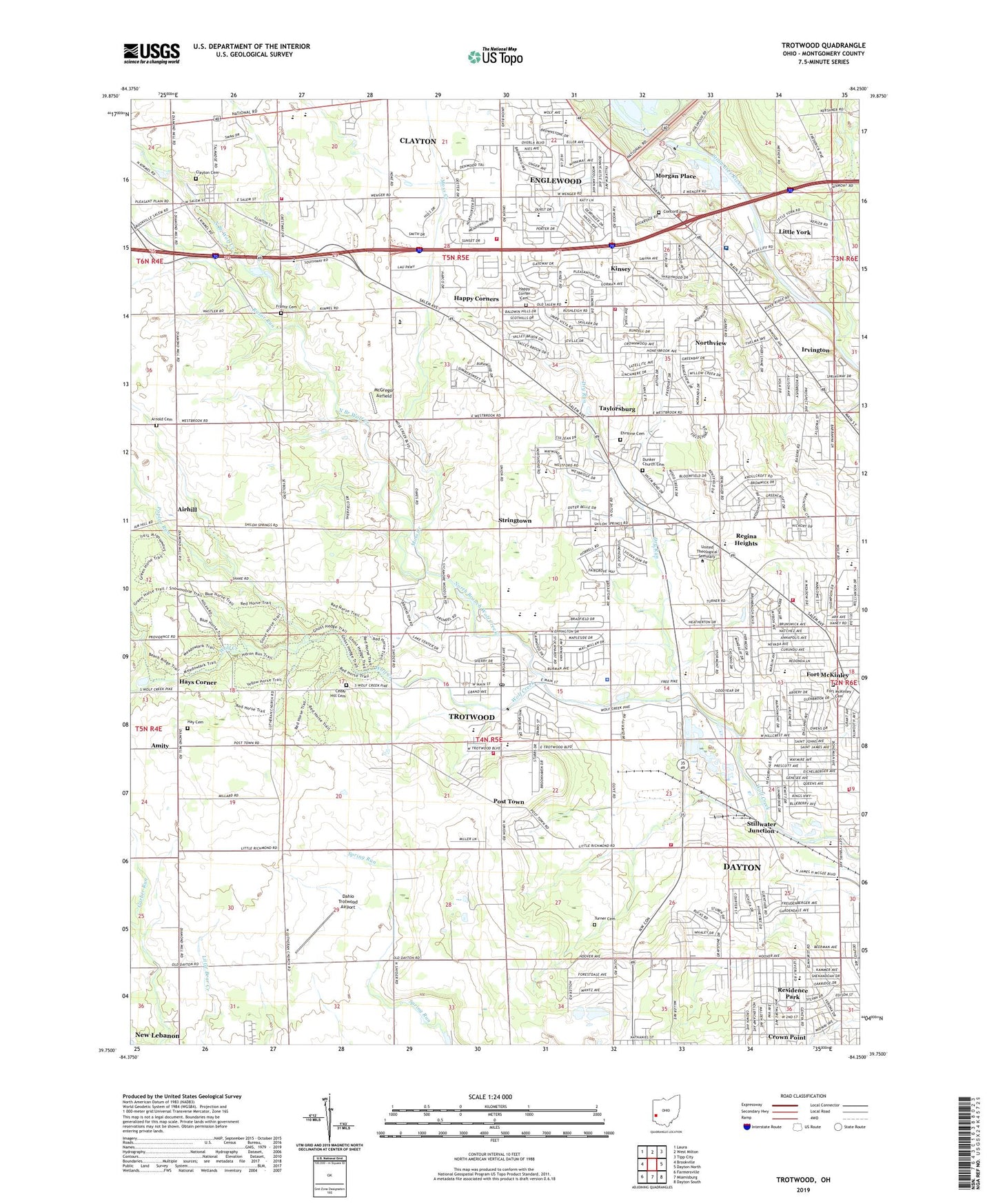
2023 topographic map quadrangle Trotwood in the state of Ohio. Scale: 1:24000. Based on the newly updated USGS 7.5' US Topo map series, this map is in the following counties: Montgomery. The map contains contour data, water features, and other items you are used to seeing on USGS maps, but also has updated roads and other features. This is the next generation of topographic maps. Printed on high-quality waterproof paper with UV fade-resistant inks.
Quads adjacent to this one:
West: Brookville
Northwest: Laura
North: West Milton
Northeast: Tipp City
East: Dayton North
Southeast: Dayton South
South: Miamisburg
Southwest: Farmersville
This map covers the same area as the classic USGS quad with code o39084g3.
Contains the following named places: Airhill, Amity, Amity Post Office, Antioch Church, Arnold Cemetery, Beech Ridge Trail, Belle Haven Elementary School, Bethel Pentecostal Temple, Broadmoor Elementary School, Brookville Lakes Estates, Canaan Mission Baptist Church, Catalpa Grove Mobile Home Park, Cedar Hill Cemetery, Christ Holy Temple, Church of God Militant Pillar and Ground of Truth, City of Clayton, City of Englewood, City of Trotwood, Clayton, Clayton Cemetery, Clayton Fire Department Station 84, Clayton Fire Department Station 85, Clayton Post Office, Clayton United Methodist Church, Concord Cemetery, Concord Church, Crown Point, Dahio Trotwood Airport, Dayton Fire Department Station 16, Dayton Meadowbrook Country Club, Deerpark Village, Deeter Nurseries, Dry Run, Ebenezer Baptist Church, Ehrstine Cemetery, Englewood Dam, Englewood Elementary School, Englewood Fire Department Station 99, Englewood Hills Elementary School, Englewood Hills South Park, Englewood Industrial Park, Englewood Municipal Park, Englewood Recreation Dam, Englewood Reserve, Englewood Reservoir, Ethan Temple Seventh Day Adventist Church, Feller's Farm, First Genesis Baptist Church, Fort McKinley, Fort McKinley Cemetery, Fort McKinley Elementary School, Fort McKinley United Methodist Church, Frantz Cemetery, Gardendale Playground, Gardendale School, Gettysburg Preschool Center, Ghost Hedge Nature Trail, Golden Key Village Shopping Center, Grace Apostolic Church, Grace Assembly of God Church, Grace Brethren Church of Trotwood, Grace Church, Grace Missionary Baptist Church, Great Western Industrial Park, Happy Corner Cemetery, Happy Corners, Hara Arena, Harrison Community Park, Hay Cemetery, Hays Corner, Heathcliff Office Park, Heathcliff Wellfield Park, Heron Run Trail, Hickorydale Elementary International Heritage Academy, Hickorydale Park, High Light Baptist Church, Holiness Church, Irvington, John Wolfe Park, Kimco Shopping Center, Kinsey, Kinsey Post Office, Larch Tree Golf Course, Little York, Littleyork Post Office, Love Chapel Church of God in Christ, Lower Stillwater Cemetery, Madison Lakes Park, Madison Park Elementary School, Main Meadows Mobile Home Park, McGregor Airfield, Meadowdale Elementary School for Science, Meadowdale High School for Cultural Studies/International Baccalaureate, Meadowlark Trail, Metropolitan Missionary Baptist Church, Miami Valley Career Technology Center Airport, Millhaven Park, Miracle Lane Shopping Center, Monnin Fruit Farm, Montgomery County, Morgan Place, Moss Creek, Mount Moriah Baptist Church, National Audubon Society, Nettie Lee Roth Middle School, New Gettysburg Baptist Church, New Testament Missionary Baptist Church, North Branch Wolf Creek, North Broadway Park, Northmont High School, Northmont Junior High School, Northmont Plaza Shopping Center, Northmoor Elementary School, Northview, Northview Elementary School, Northview Estate Park, Northwood Elementary School, Oberer Field, Ohio State Highway Patrol - Dayton Patrol Post, Olivehill Elementary School, Omega Missionary Baptist Church, Peoples Community Christian Methodist Episcopal Church, Philippi Missionary Baptist Church, Pinchtown, Poplar Run, Post Town, Precious Blood Childrens Home, Precious Blood Convent, Precious Blood School, Prescott Avenue United Brethren in Christ Church, Randolph Plaza Shopping Center, Razor Run, Regina Heights, Residence Park, Residence Park Church of Christ, Residence Park Elementary School, Residence Park United Methodist Church, Riverside Chapel, Saint Matthew Missionary Baptist Church, Saint Paul African Methodist Episcopal Church, Saint Theresa Spiritual Church of Christ, Saint Timothy Missionary Baptist Church, Salem Consumer Square Shopping Center, Salem Mall Shopping Center, Salem Plaza Shopping Center, Salem Village Park, Samaritan North Health Center, Second Thessalonians Baptist Church, Shilohview Elementary School, Sixmile, Stillwater Junction, Stillwater Sanitarium, Stringtown, Sycamore Conservation and Education Farm, Sycamore State Park, Taylorsburg, Taylorsburg Post Office, Township of Madison, Township of Randolph, Townview Baptist Church, Townview Elementary School, Triumphant Cross Lutheran Church, Trotwood, Trotwood Church of the Brethren, Trotwood Community Park, Trotwood Fire Department Station 72, Trotwood Fire Department Station 73, Trotwood Fire Department Station 74, Trotwood Industrial Park, Trotwood Main Shopping Center, Trotwood Police Department, Trotwood Post Office, Trotwood United Church of Christ, Trotwood-Madison High School, Trotwood-Madison Junior High School, Turner Cemetery, Union Church, Westbrook Road Park, Westbrooke Village Elementary School, Westbrooke Village Park, Western Hills Park, Zebulon Missionary Baptist Church, ZIP Codes: 45315, 45415, 45416, 45426