MyTopo
Wilmington Ohio US Topo Map
Couldn't load pickup availability
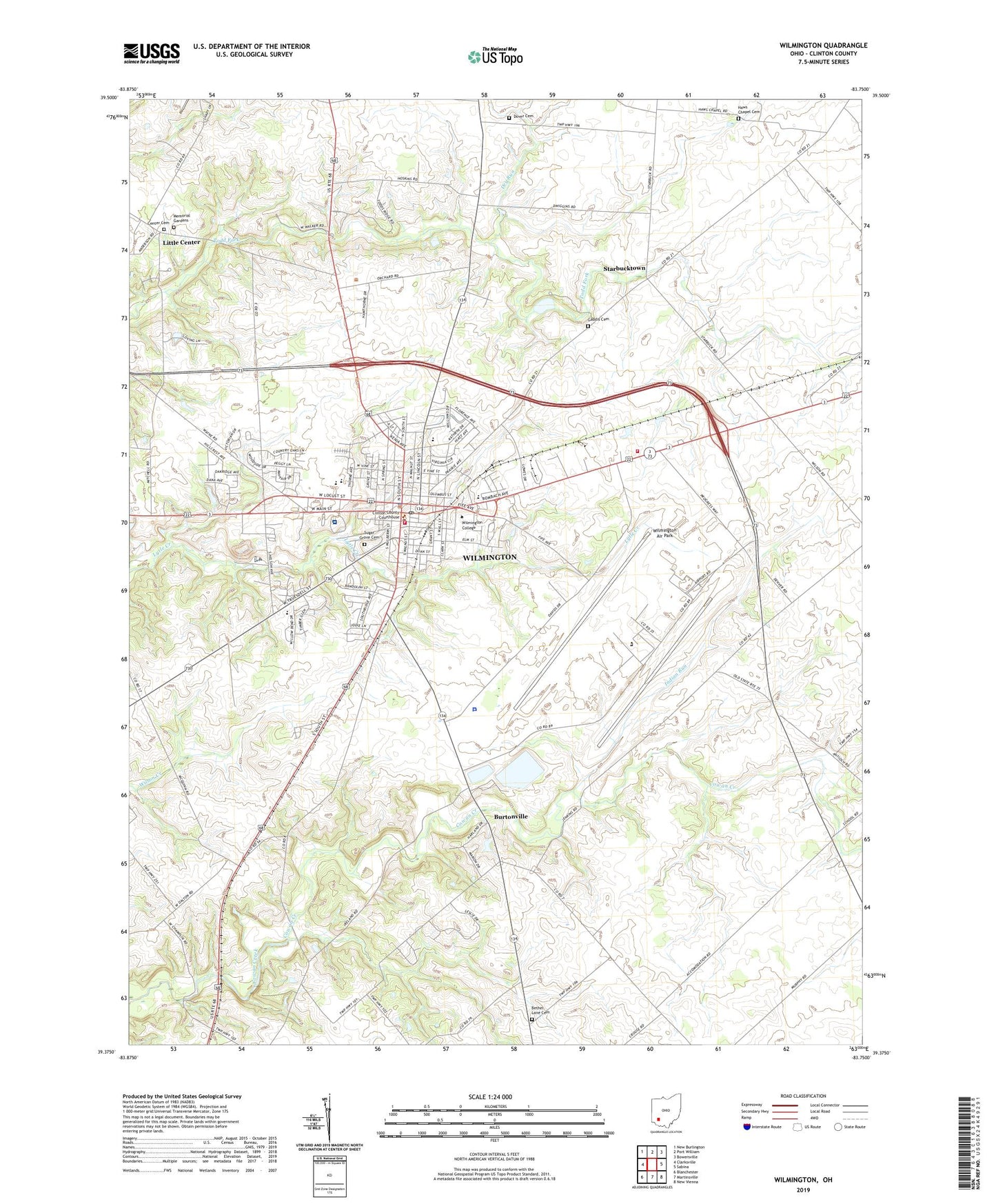
2023 topographic map quadrangle Wilmington in the state of Ohio. Scale: 1:24000. Based on the newly updated USGS 7.5' US Topo map series, this map is in the following counties: Clinton. The map contains contour data, water features, and other items you are used to seeing on USGS maps, but also has updated roads and other features. This is the next generation of topographic maps. Printed on high-quality waterproof paper with UV fade-resistant inks.
Quads adjacent to this one:
West: Clarksville
Northwest: New Burlington
North: Port William
Northeast: Bowersville
East: Sabina
Southeast: New Vienna
South: Martinsville
Southwest: Blanchester
This map covers the same area as the classic USGS quad with code o39083d7.
Contains the following named places: Austin Hall, Bailey Hall, Base Chapel, Bethel Lane Cemetery, Boyd Auditorium, Burtonville, Center Cemetery, Chakeres Wilmington Drive-In, Church of Christ, Church of Christ in Christian Union, City of Wilmington, Clinton, Clinton County, Clinton County Air Force Base, Clinton County Courthouse, Clinton County Fairgrounds, Clinton County Historical Society Museum, Clinton County Home, Clinton County Sheriff's Office, Clinton County Tributary Number One Dam, Clinton Medical Transport, Clinton Memorial Hospital Heliport, CMH Regional Health System Clinton Memorial Hospital, College Hall, Cowan Creek, David R Williams Memorial Park, Delaney-Tewksbury Baseball Diamond, Denver Place Elementary School, Dover Cemetery, Dover Church, Dry Run, Dutch School, East End Elementary School, Faith Lutheran Church, First Baptist Church, First Christian Church, Friends Hall, Gaddis Cemetery, Galvin Park, Goodman Carillon, Haws Chapel, Haws Chapel Cemetery, Hermann Court, Indian Run, Kathryn Denver Memorial Hall, Kelly Center, Little Center, Marble Hall, McMahan's Mobile Home Park, Memorial Gardens, Midland School, Murphy Theatre, New Antioch School, Ohio State Highway Patrol - Wilmington Patrol Post, Pickett Hall, Pyle Center for Students, Quail Lakes Heliport, Quinn African Methodist Episcopal Church, Robinson Hall, Rodger O Borror Elementary School, Roy E Holmes Elementary School, Saint Anthonys Church, Saint Columbkille Catholic Church, Second Baptist Tabernacle, Sheppard Arthur Watson Library, Smith Place School, Starbucktown, Sugar Grove Cemetery, Town And Country Estates, Townsend Field, Township of Union, White's Mobile Home Park, Williams Stadium, Wilmington, Wilmington Air Park, Wilmington Assembly of God Church, Wilmington Church of God, Wilmington College, Wilmington Commercial Historic District, Wilmington Fire Department Station 2, Wilmington Fire Department Station 1, Wilmington Friends Meeting House, Wilmington High School, Wilmington Plaza Shopping Center, Wilmington Police Department, Wilmington Post Office, Wilmington Presbyterian Church, Wilmington Public Library, Wilmington Reservoir Number One, Wilmington Reservoir Number Two, Wilmington Sanitary Landfill, Wilmington Seventh Day Adventist Church, Wilmington United Methodist Church, Wilmington Upground Reservoir Dam Number One, Wilmington Upground Reservoir Number Two Dam, Wilmington Wastewater Treatment Plant, Wilmington Water Treatment Plant, Winter Haven Farm, WKFI-AM (Wilmington), ZIP Code: 45177