MyTopo
Northeast Muskogee Oklahoma US Topo Map
Couldn't load pickup availability
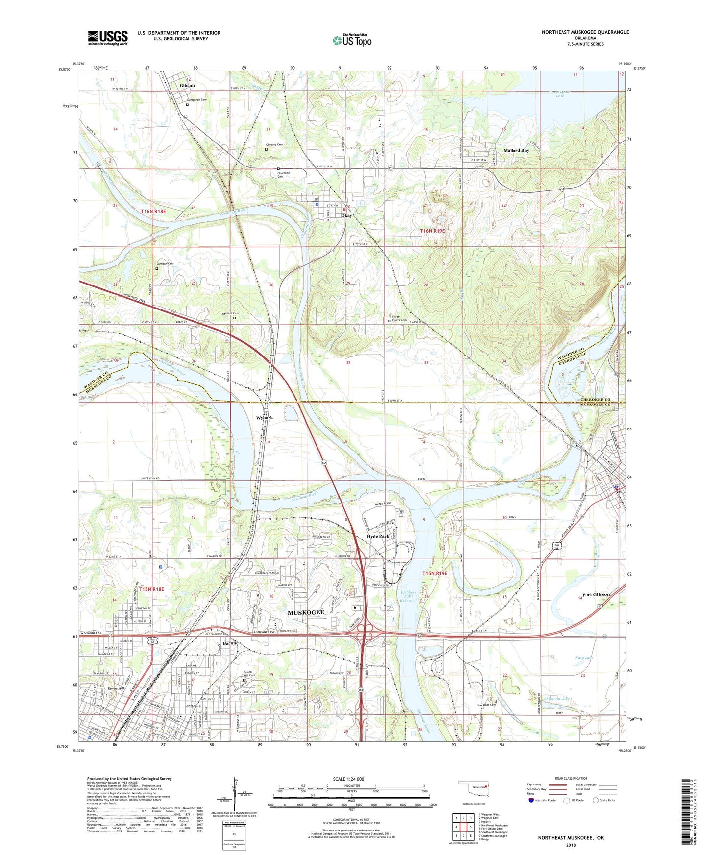
2022 topographic map quadrangle Northeast Muskogee in the state of Oklahoma. Scale: 1:24000. Based on the newly updated USGS 7.5' US Topo map series, this map is in the following counties: Muskogee, Wagoner, Cherokee. The map contains contour data, water features, and other items you are used to seeing on USGS maps, but also has updated roads and other features. This is the next generation of topographic maps. Printed on high-quality waterproof paper with UV fade-resistant inks.
Quads adjacent to this one:
West: Northwest Muskogee
Northwest: Wagoner West
North: Wagoner East
Northeast: Hulbert
East: Fort Gibson Dam
Southeast: Braggs
South: Southeast Muskogee
Southwest: Southwest Muskogee
This map covers the same area as the classic USGS quad with code o35095g3.
Contains the following named places: Anderson Bottoms Cemetery, Arrowhead Mall, Ash Street Missionary Baptist Church, Bacone, Bacone College, Bacone College Baptist Church, Cherokee Cemetery, Chouteau Lock, Chouteau Lock and Dam 17, Chouteaus Old Trading House, Church of God East Shawnee, Civitan Park, Clingan Cemetery, Clinging Creek, Correll Branch, Curts Shopping Center, Dry Branch, Eastar Health System - East Campus, Eastside Church of Christ, Elliott Park, Evergreen Cemetery, Faith Mission Church, First Baptist Church, First Presbyterian Church, First United Methodist Church, Fort Gibson, Fort Gibson Church of Christ, Fort Gibson Fire Department, Fort Gibson Police Department, Fort Gibson Post Office, Fort Gibson Stockade, Gibson, Grace Episcopal Church, Greater Shiloh Baptist Church, Green Hill Cemetery, Harris Jobe Elementary School, Horseshoe Lake, Hyde Park, Indian Capital Technology Center - Muskogee, Irving Elementary School, Jamison Cemetery, Katy Lake, KBIX-AM (Muskogee), Kenyon Church, Lawrence Street Baptist Church, Lower Verdigris Falls, Mallard Bay, Mallard Bay Census Designated Place, Mallard Bay Recreation Area, Marshall Cemetery, Metropolitan Baptist Church, Muskogee Country Club, Muskogee County Sheriff's Office, Muskogee High School, Muskogee Price Mart, Neosho River, New Life Center Church, Northpointe Plaza Shopping Center, Oak Grove Church, Okay, Okay Elementary School, Okay High School, Okay Police Department, Okay Post Office, Okay Volunteer Fire Department, Oklahoma School For The Blind, Old Channel Verdigris River, Parkview School for the Blind - Elementary School, Port of Muskogee, Riverside School, Ross Lake, Sadler Arts Academy, Shiloh Baptist Church, Shimoon Lake, Three Rivers Cemetery, Tower Hill, Town of Fort Gibson, Town of Okay, Township of Shannon, Trinity United Methodist Church, Verdigris River, War Memorial Park, Wybark, ZIP Code: 74446